I’m so excited to be coming home that I wake up at 3:30 this morning in my Wickenburg hotel room. No alarm clock. It just happens.
I remember that it’s no fun riding on a hot day. Today’s forecast is for temperatures in the low 100s in La Quinta and other desert locales along the way.
So, without hesitation — even at 3:30 a.m. — I jump out of bed, shower, load the bike, and am out of Wickenburg at 4:15. This is great for two reasons. First, I’ll avoid the worst of the heat. And second, by leaving early, I may beat Ray home. He has more than 535 miles to go, and I have “only” 275. Edge in the “who’s-gonna-make-it home-first” contest goes to me.
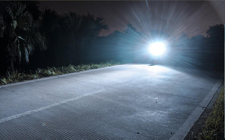
I’m on US-60, riding west for 50 miles or so, mostly in the dark. It’s a very boring road; not a turn to be had. But I can see forever, thanks in part to a new LED headlight I had installed before I left on this trip. George at Valley V-Twin promised the light would be blinding. He was right.
Super bright headlight helps cut the early morning darkness.
As I approach I-10, I get to watch the sun rise in my rear-view mirror. About 10 miles after getting on the interstate, I roll by Quartzsite, Arizona.
Quartzsite calls itself the Rock Capital of the World. Cleveland, Ohio, calls itself the Rock and Roll Capital of the World. Where would you rather be?
Sometimes referred to as America’s largest parking lot, Quartzsite is at the junction of I-10 and US-95. It’s a popular recreational vehicle camping area for winter visitors. It has 9 major gem and mineral swap meets during the year, as well as 15 general swap meets.
Swapping is quite popular in Quartzsite. The swap meets are said to attract about 1.5 million people each year, primarily in January and February.
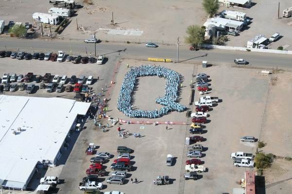
In March 2014, with the swap season on hiatus, Quartzsite made big news when it was recognized with a new Guinness World Record. On March 9, 631 people got together and formed the letter “Q” … successfully setting a record for Largest Human Letter. Why Q? It’s the first letter in Quartzsite. You can’t make this stuff up.
631 People form the letter Q in a Quartzite parking lot. Who knew?
At 880 feet elevation, Quartzsite is 18 miles east of the Colorado River.
***
With nothing to swap today, I continue west toward the Arizona-California border, which is formed by the Colorado River.
Blythe is the California town in the Sonoran Desert that sits on the western bank of the Colorado. Blythe, elevation 272 feet, was named after Thomas Blythe, a San Francisco financier who established primary water rights to the Colorado River in 1877.
Blythe is a stopover city for travelers – particularly between Los Angeles and Phoenix. It’s about midway between those two cities.
Its population is nearly 21,000. Not much to do here, other than the Blythe Bluegrass Festival in January, and an opportunity to stop for a cold drink on the way from somewhere to somewhere else.
Also popular in Blythe: dove hunting. The season begins September 1.
***
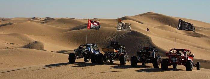
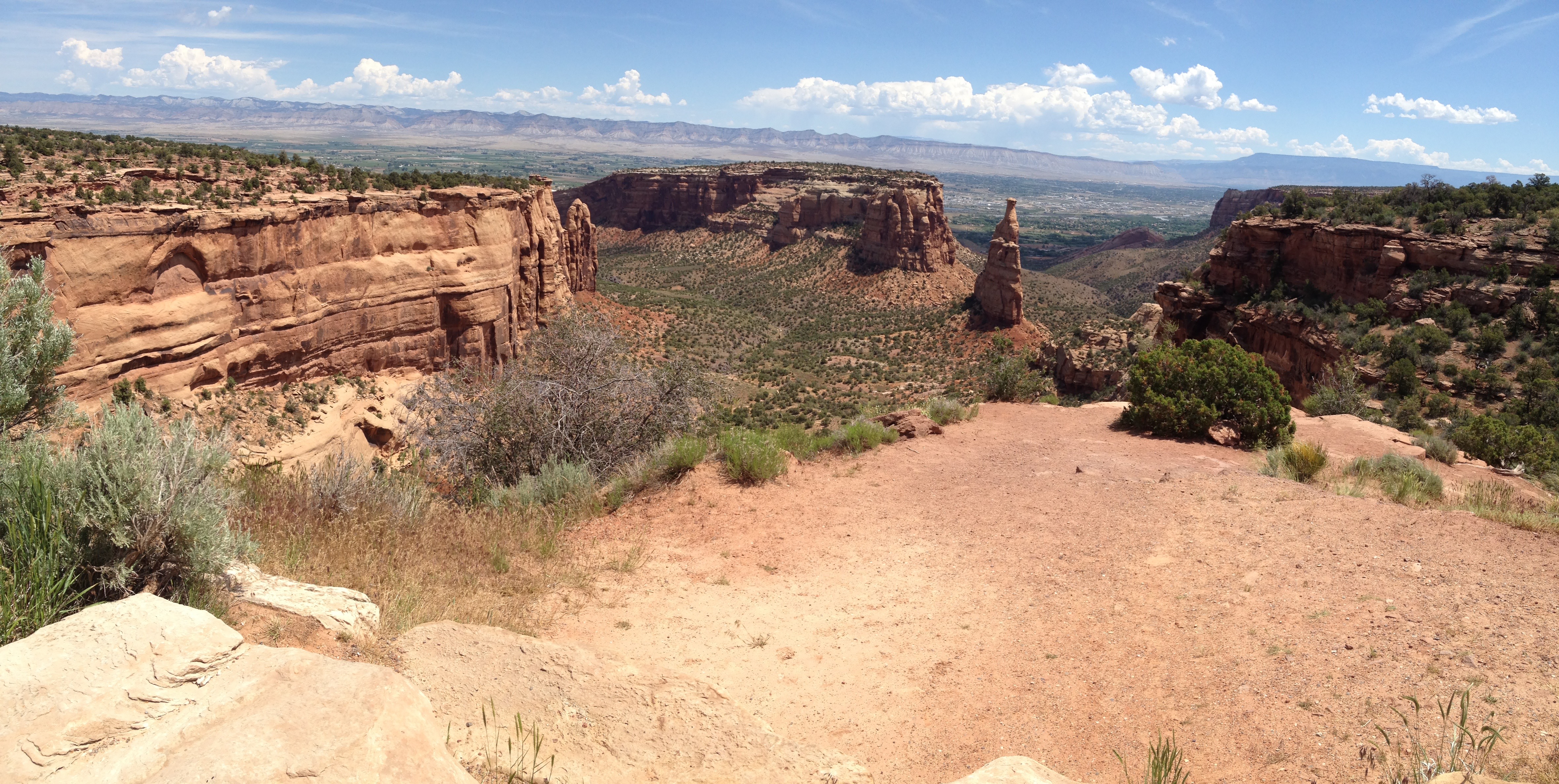
From Blythe, I head south on CA-78. The road takes me through Ripley, past the Cibola National Wildlife Refuge, Picacho Peak Wilderness Area, and the Imperial Sand Dunes Recreation Area.
The Imperial Sand Dunes Recreation Area, a haven for off-roaders.
The sand dunes are a haven for off-road vehicles. The dunes were used to film parts of many Hollywood films, including Road to Morocco, Flight of the Phoenix, and Return of the Jedi. The area is part of the Algodones Dunes.
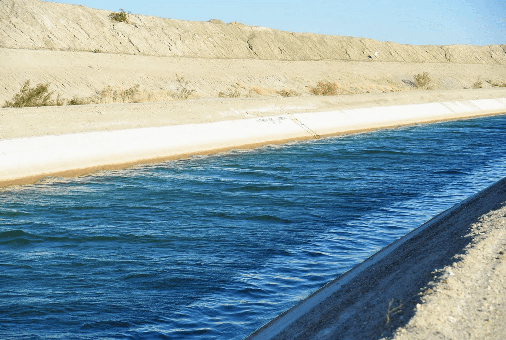
The only significant man-made structure in the area is the All-American Canal. It cuts across the southern portion of the Dunes. The All-American Canal is an 80-mile long aqueduct that brings water from the Colorado River into the Imperial Valley and to nine cities. The canal is the Imperial Valley’s only water source for residents and area farmlands.
The canal, which runs parallel to the Mexico-California border for several miles, has been called “The Most Dangerous Body of Water in the U.S.” It has deep, cold water, steep sides that make escape difficult, and swift currents that can reach 5.45 miles an hour. More than 500 people have drowned in the canal since 1997, mostly migrants attempting to cross the US-Mexico border.
The All-American Canal is owned by Bureau of Reclamation, but operated by the Imperial Irrigation District, which supplies power to our home and others in La Quinta and the East Coachella Valley. The All-American Canal feeds water into the Coachella Canal, primarily for agricultural use in the Coachella Valley, which includes La Quinta.
The Coachella Canal, providing water for me and Sarah.
The Coachella Canal is managed by the Coachella Valley Water District, which supplies water to our home, and sends Sarah and me a $10 water bill every month. This canal runs along holes fourteen through seventeen on the Arnold Palmer Course at PGA West, and is full of both fish and golf balls.
The Coachella Canal’s cut through PGA West is featured in Soarin’ Over California, a flight simulator attraction at the Disney’s California Adventure, adjacent to Disneyland. Click here to watch the video, whose PGA West scene is at the 2:30 mark.
All that canal talk reminds me – hope someone’s been paying our Imperial Irrigation District ($300/month) and Coachella Valley Water ($10/month) bills while I’ve been on the road. If not, I’d better get home soon.
***
The Imperial Sand Dunes are not far from the city of Brawley, elevation 112 feet below sea level. Agriculture is Brawley’s primary industry. The city was named after J.H. Braly, who originally owned the land. After Braly refused to permit the use of his name, the name of the city was changed to Brawley.
Notable people from Brawley include:
Helen Fabela Chavez, former labor activist for the United Farm Workers of America, and widow of Cesar Chavez. In the 2014 bio-pic about Cesar Chavez, One Step at a Time, Helen is played by America Ferrera. Click here to watch the trailer.
The Bella Twins, Brie and Nikki, are models and professional wrestlers who work for WWE. They do tag team wrestling, and starred in the 2013 TV reality show, Total Divas. Being pinned by them might not be such a bad thing. Click here to see why.
Sid Monge, a retired Major League baseball relief pitcher, who played professionally from 1975 to 1984 for the California Angels, Cleveland Indians, Detroit Tigers, Philadelphia Phillies and San Diego Padres. Monge, born in Mexico, is in the Mexican Baseball Hall of Fame.
***
Brawley is just 70 miles from home in La Quinta.
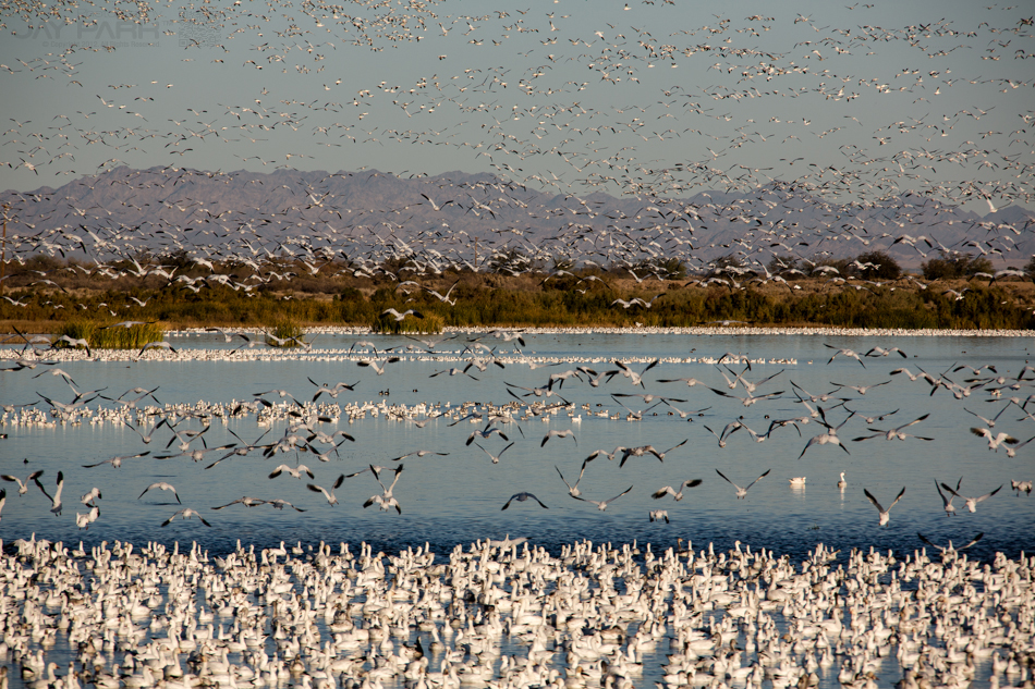
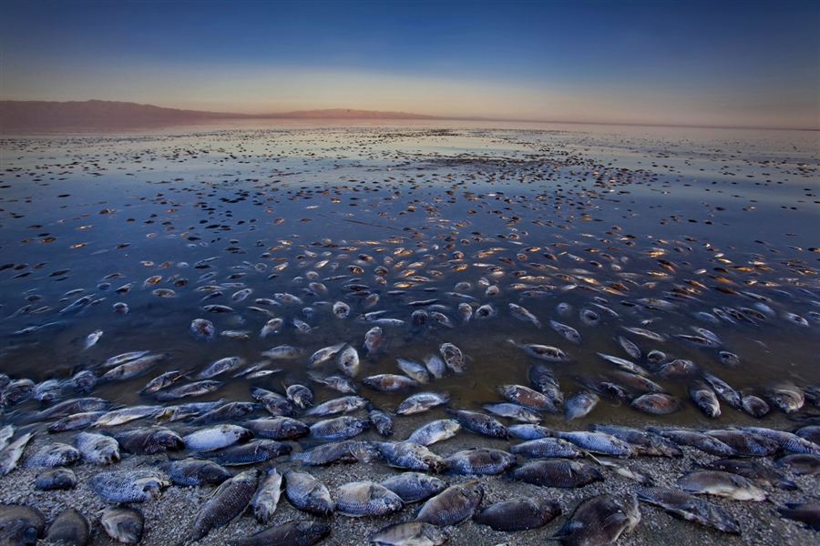
Migrating birds at the Sonny Bono Salton Sea National Wildlife Refuge.
I follow the western shore of the Salton Sea on CA-86, riding northwest through Salton City. I pass the Sonny Bono Salton Sea National Wildlife Refuge, named after the former entertainer, one-time Palm Springs Mayor, and U.S. Congressman from California.
The refuge was established in 1930 as a sanctuary and breeding ground for birds and wild animals, then renamed after Bono, who played an active role in trying to save the Salton Sea. I got you, Babe.
Speaking of which, click here to reacquaint yourself with the almost-50-year-old song.
The Salton Sea, 225 feet below sea level, is the largest lake in California – estimated at 362 square miles, and shrinking every day. It was the result of an accident, created by a flood in 1905, when water from the Colorado River flowed into the area.
At one time, in the 1950s, the Salton Sea had resorts on its western and eastern shores. But today, these areas are mostly abandoned and are little more than a tourist’s curiosity and beaches full of dead tilapia.
***
The northwest corner of the Salton Sea is only about 10 miles from home.
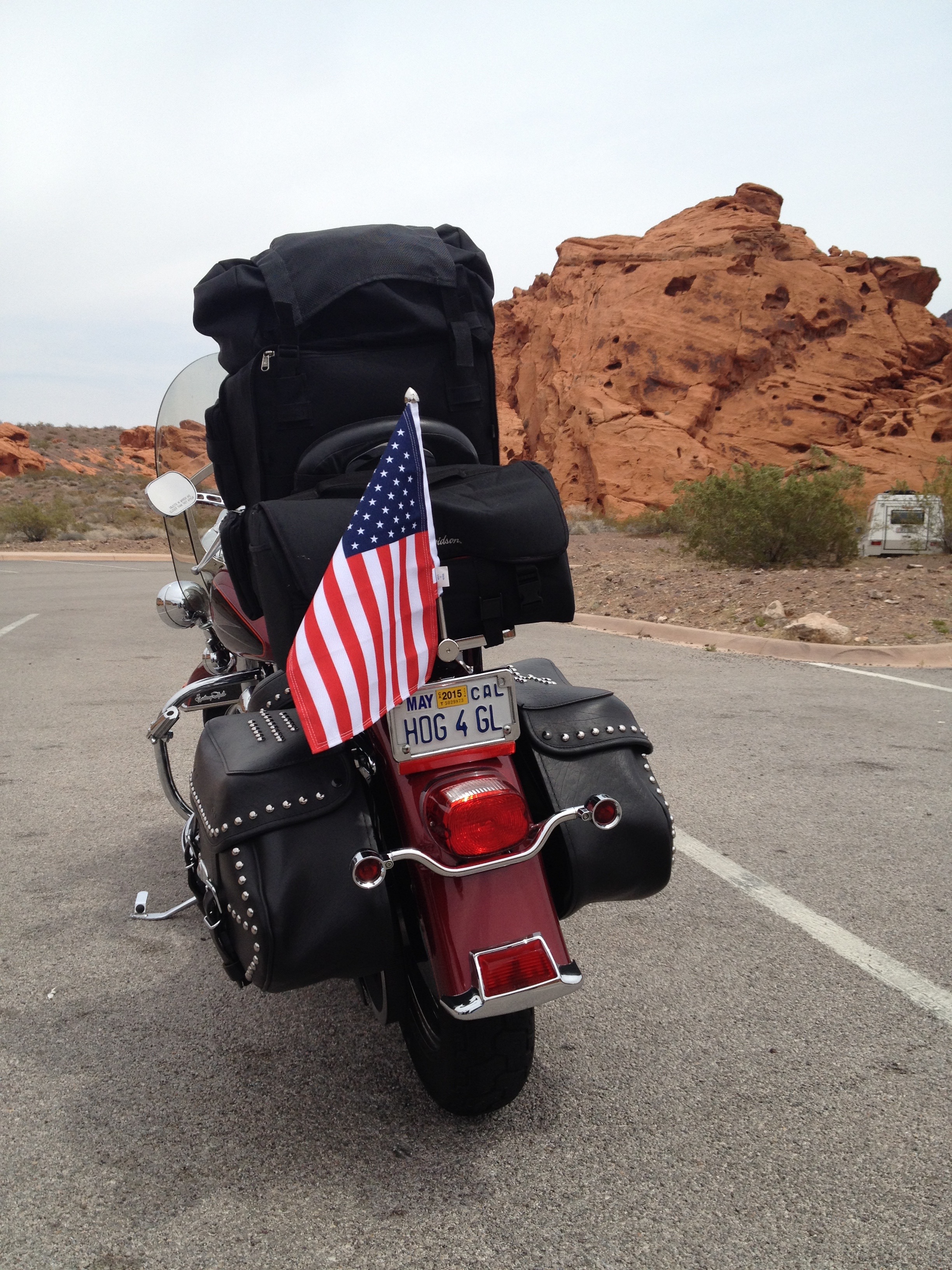
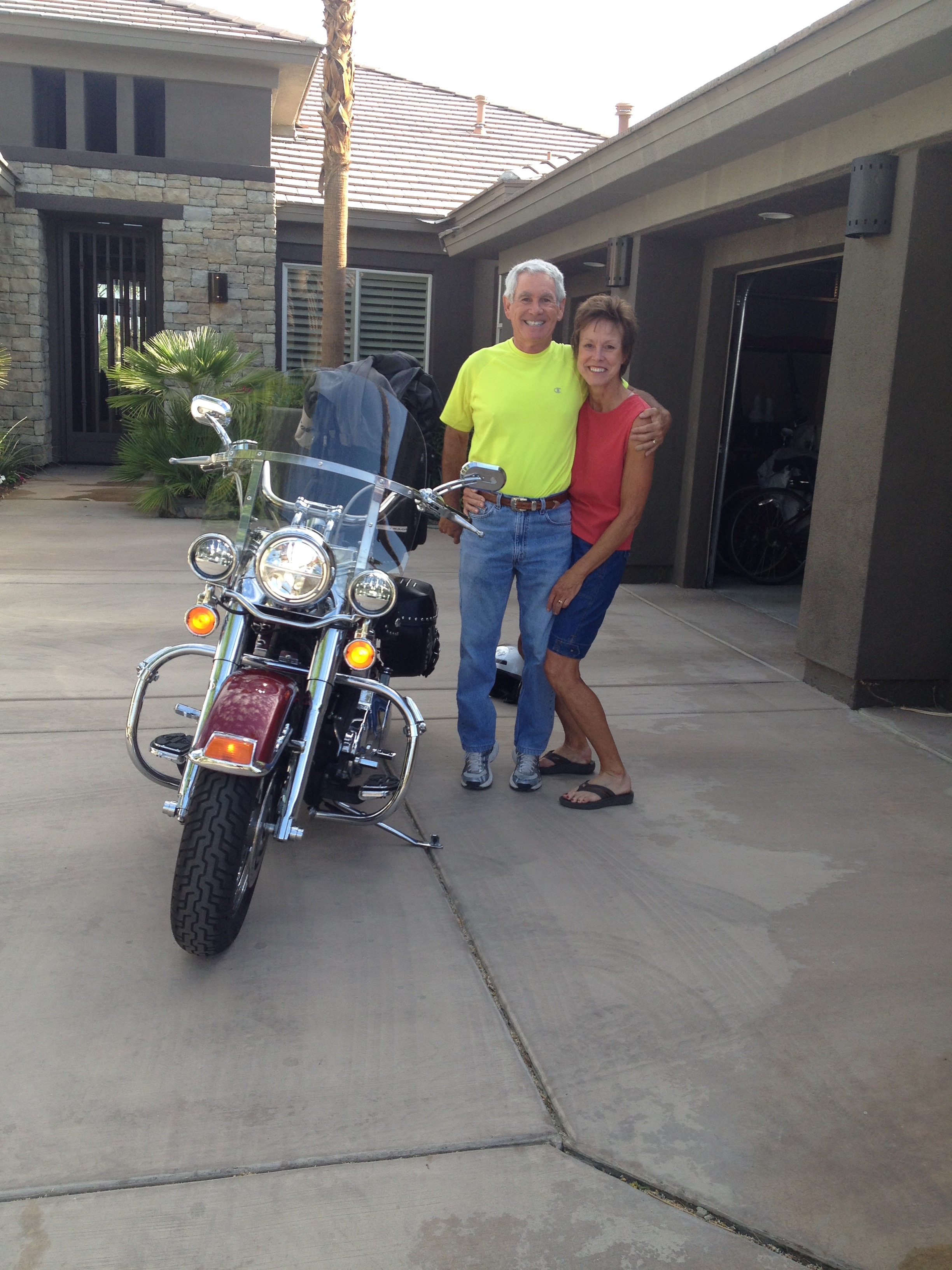
In no time at all, I’m in the driveway at 81640 Tiburon Drive, unpacking.
Spoiler alert: I’m home!
After 17 days and 4,255 miles, I’m home.
Sarah documents my arrival at 10:45
I managed to beat the heat.
More importantly, I beat Ray home. He arrives at his Farragut, Tennessee, home at 3:45 pm (12:45 Pacific Time).
If I hadn’t snapped up out of a cold sleep this morning at 3:30, Ray would have made it home first and I’d be eating crow until next year.
For those of you betting on me to get home first, nice going. Do you have any money on California Chrome?
***
Hope you enjoyed being a part of the journey on my Ride Through the Rockies. It was nice having you along for the ride.
In the somewhat unlikely event that you learned anything these past few weeks, you’re welcome.
See you on next year’s ride. You in?
Home at last, and already cooling off.
***
Day Seventeen Summary: Dove hunting in Blythe, wrestling with the Bella Twins, soarin’ over California, coming home!
Click here to view today’s route from Wickenburg to La Quinta.
For the first time in two weeks, I wake up with no one to talk to. Ray’s probably halfway to Tennessee, and I still have two days of riding before arriving home in La Quinta.
Let’s get it started.
I head west on AZ-260, leaving the poker capitol of Arizona on West Deuce of Clubs. I ride through Sitgreaves National Forest, toward the town of Heber-Overgaard, situated atop the Mogollon Rim at about 6,400 feet.
Heber was founded in 1883 by Mormon pioneers; Overgaard was settled in the 1930s and named after the owner of its first sawmill. Someone found a surplus hyphen somewhere and decided to call the place Heber-Overgaard.
Today, Heber-Overgaard exists as a retirement and tourism locale.
***
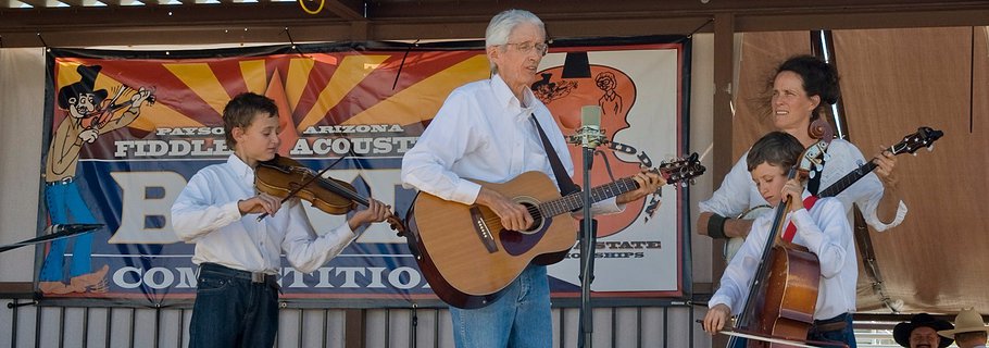
I’m almost halfway to the mountain town of Payson, which sits at 5,000 feet in the Tonto National Forest at the intersection of AZ-260 and AZ-87. Payson is almost exactly in the geographic center of Arizona. It’s motto: “Arizona’s Cool Mountain Town.”
Payson had its first rodeo 130 years ago, in 1884. Payson considers the event to be the world’s oldest continuous rodeo, as it’s been held every year since.
In 1918, the author Zane Grey made his first trip to the area near Payson. He came back regularly over the next 10 years, purchasing several plots of land and eventually writing numerous books about the area.
Fiddling around at the Old Time Fiddlers Contest in Payson.
Every September, Payson hosts the annual Arizona State Championship Old Time Fiddlers Contest, featuring both local and nationally known players.
I have no time for fiddling around, so I continue northwest on AZ-260, the Zane Grey Highway.
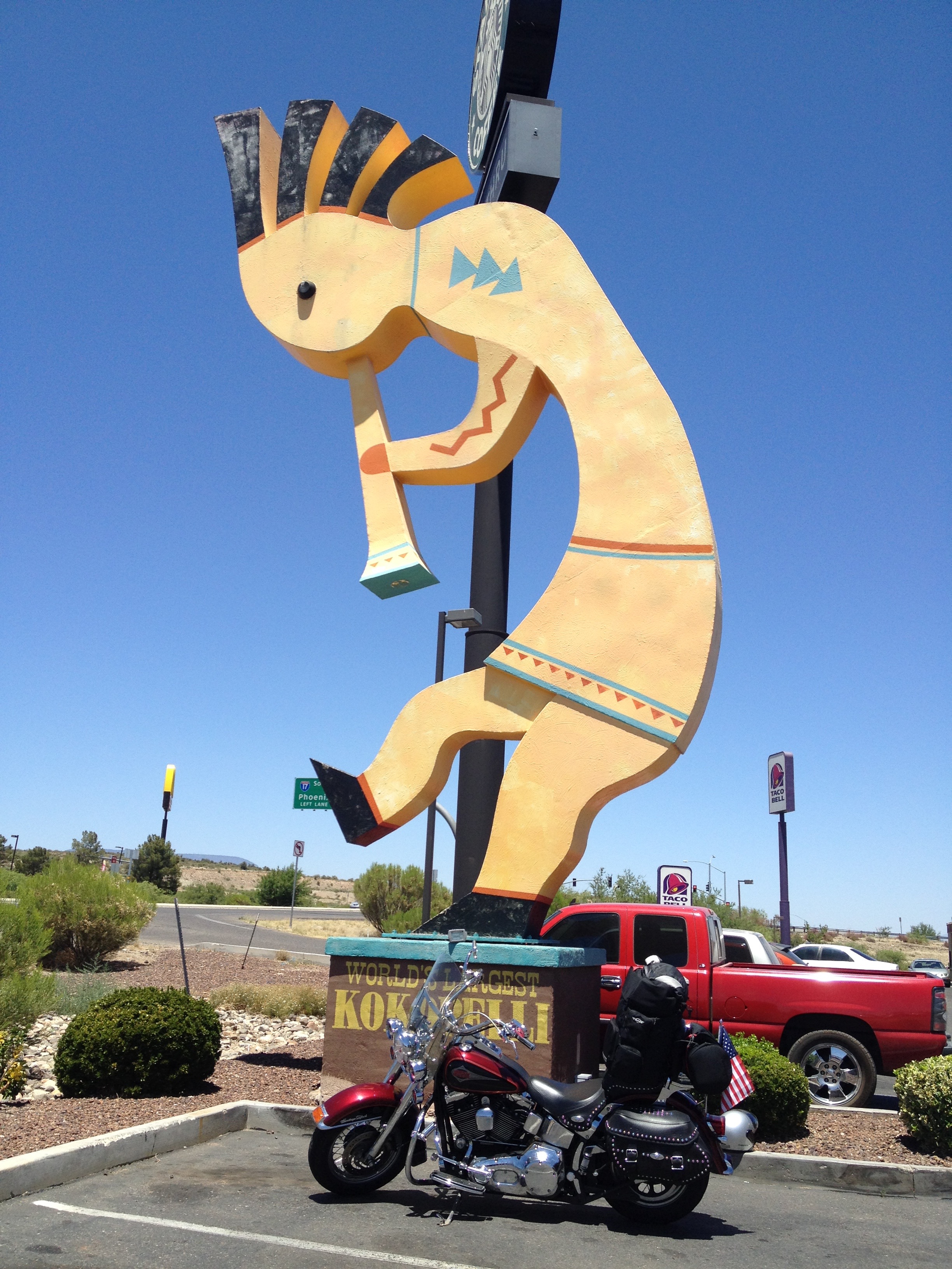
I’m riding toward Camp Verde, home of a 32-foot-tall kokopelli, the world’s largest. A kokopelli is a fertility deity, usually depicted as a humpbacked flute player. The kokopelli is a big deal in many Native American cultures in the southwest. You’ll often see them in tourist shops in Arizona. Camp Verde’s ginormous kokopelli sits in front of the Krazy Kokopelli Trading Post.
Parking in front of the world’s largest kokopelli, in Camp Verde.
Camp Verde, at 3,147 feet, sits on the banks of the Verde River. The city doesn’t have much going on other than its kokopelli-on-steroids, and an occasional festival. It holds Fort Verde Days in October; the Pecan, Wine and Antiques Festival in February; and the Crawdad Festival, scheduled for later this month.
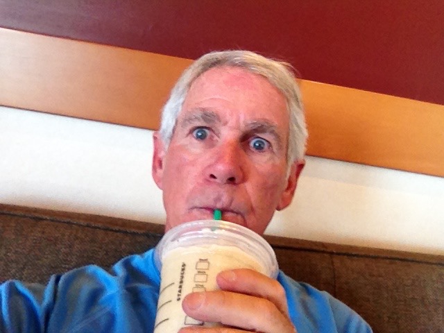
In Camp Verde, it’s noon, and the temperature is already in the 90s. I remember Sarah’s less-than-gentle reminders to hydrate adequately.
So I duck into the Starbucks at the foot of the giant kokopelli for a coffee frapuccino. It is just what I need to stay cool and saturated. That’s my idea of hydration!
Hydrating at the Camp Verde Starbucks, with a cold Frappuicino.
***
I cross I-17, following the Verde River to the town of Cottonwood. Here, I turn west on AZ-89A and head 2,000 feet up the mountain for the steep 5-mile ride to the historic mining town of Jerome.
Jerome, elevation 5,066 feet, was named for Eugene Murray Jerome, a New York investor in the early mining operations on Cleopatra Hill, which dominates Jerome’s horizon. A prominent “J” is still visible on Cleopatra Hill.
Supported in its heyday by rich copper mines, Jerome was once home to 15,000 people. Today, its population is less than 500, but it’s big enough to have its own website, which says Jerome was once known as the wickedest town in the west.
Jerome sits above what was once the largest copper mine in Arizona, producing 3 million pounds of copper every month. As the ore deposits became exhausted in the 1950s, the mines closed and Jerome took on a new persona. It became a National Historic Landmark in 1967, and today is an art community, with coffee houses, wineries, and a local museum devoted to mining history.
Jerome is a great place for art, and motorcycles.
Jerome’s funky, artistic vibe attracts musicians, writers, and plenty of tourists – like me – who walk its narrow, winding streets.
Notable people with a Jerome connection:
Fred Rico, former major league baseball player, born in Jerome on July 4, 1944. He made $6,000 playing for the Kansas City Royals in 1969, hitting .231 in 12 games while playing third base and right field.
Maynard James Keenan, singer, songwriter and musician, best known as the vocalist for Grammy Award-winning progressive metal band Tool. Can’t honestly say I’m familiar with their music. Keenan owns Caduceus Cellars winery in Jerome.
Katie Lee, 94-year-old folk singer who lives in Jerome. Lee, who studied under Burl Ives, had an early folk album called “Life is Just a Bed of Neuroses.” It’s out of print, but six of her CDs are still available. She’s in the Arizona Music Hall of Fame.
***
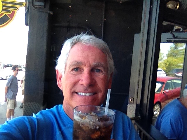
Again remembering Sarah’s hydration admonition, I stop at the Mile High Grill in Jerome for a large, cold diet Pepsi. It hits the spot, and gets me ready to continue my ride south.
More hydration at the Mile High Grill in Jerome.
After exploring Jerome’s arty side, and filling up on diet Pepsi, I continue south on AZ-89A, alternately called the Prescott-Jerome Waterway. It looks nothing like a waterway to me.
I press on toward Prescott, a mountain town designated in 1864 as the capital of the pre-statehood Arizona Territory. With many Victorian-style homes, Prescott has 809 buildings on the National Register of Historic Places.
Known for its western and cowboy feel, Prescott annually hosts Frontier Days, a rodeo (featured in the 1972 film Junior Bonner), and a Bluegrass Festival. The 2014 Bluegrass Festival, which has free admission, will be held June 21 and 22 at the Yavapai County Courthouse Plaza. This year’s bands include The Sonoran Dogs, The Mars Hillbillies, and Marty Warburton and Home Girls.
Prescott has earned a number of designations and distinctions, including being named Arizona’s Christmas City in 1989 by then Governor Rose Mofford, “A Preserve American Community in 2004 by First Lady Laura Bush, and one of a “Dozen Distinctive Designations” in 2006 by the National Trust for Historic Preservation.
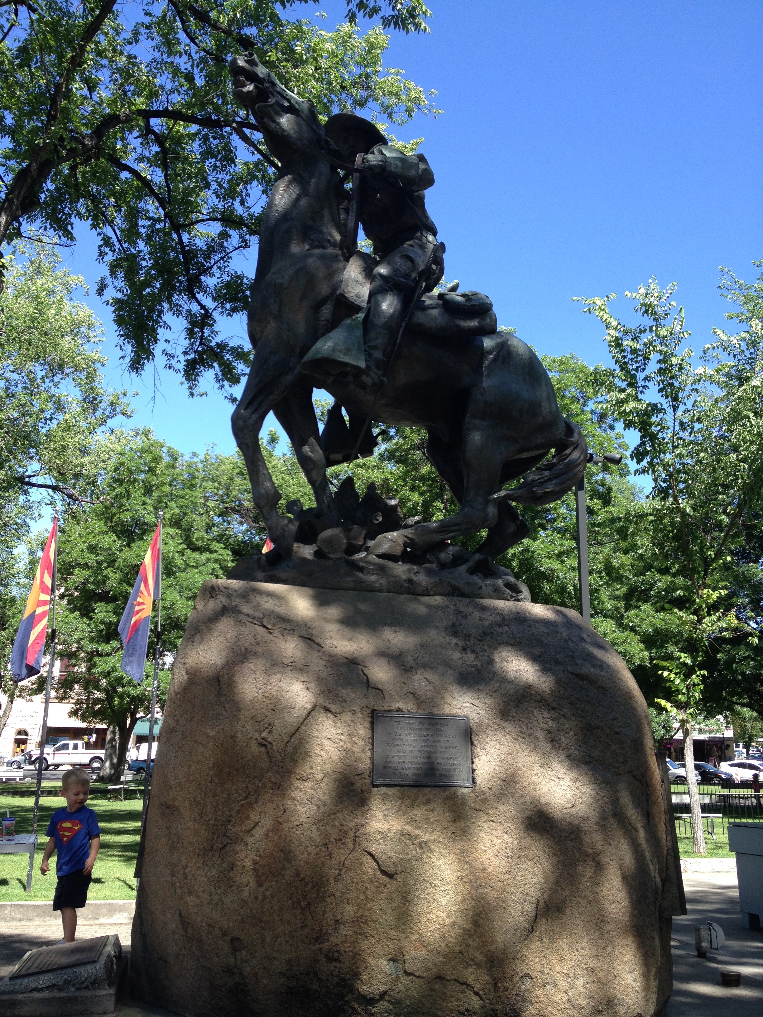
Courthouse Square statue in Prescott.
There’s a great statue in Courthouse Square, of a soldier on a horse. It honors the 1st US Volunteer Cavalry, also known as Roosevelt’s Rough Riders. The statue was sculpted by Solon Hannibal Burglum (1868-1922).
The statue is acclaimed by art critics as one of the finest equestrian monuments anywhere. At least that’s what the plaque on the statue says.
Notable residents of Prescott have included:
Piper Stoeckel, Miss Arizona 2012, born in Prescott and now senior at the University of Arizona, majoring in Broadcast Journalism and Dance. That’s an interesting academic combo. To see Piper Stoeckel remind us what broadcast journalism has become, click here.
Alan Dean Foster, science fiction author, best known for his novels set in the Humanx Commonwealth, an interstellar ethical/political union of species including humankind and the insectoid Thranx.
William Ruger, founder of Sturm, Ruger & Company, a large firearms maker. Their first product was the Ruger Standard, the most popular .22 caliber target pistol ever made in the U.S.
At 5,368 feet, Prescott is the last true mountain town on my 2014 Ride Through the Rockies.
Only way I can prove I was in Prescott is by taking a selfie at Courthouse Square.
***
Leaving Prescott, the ride to La Quinta is all downhill from here.
AZ-89 south from Prescott is a fun, twisty mountain road. Parts of it are known as the White Spar Highway, just south of Yarnell. Yarnell Hill descends 1,300 feet in just four miles and has a very popular scenic lookout point at the top.
You may recall Yarnell as the site of a tragic 2013 forest fire that took the lives of 19 firefighters from nearby Prescott. The Yarnell Hill fire overran the firefighters known as the Granite Mountain Hotshots. Arizona’s Industrial Commission, which oversees workplace safety, blamed the state’s Forestry Division for the deaths, saying state fire officials knowingly put protection of property ahead of firefighter safety.
***
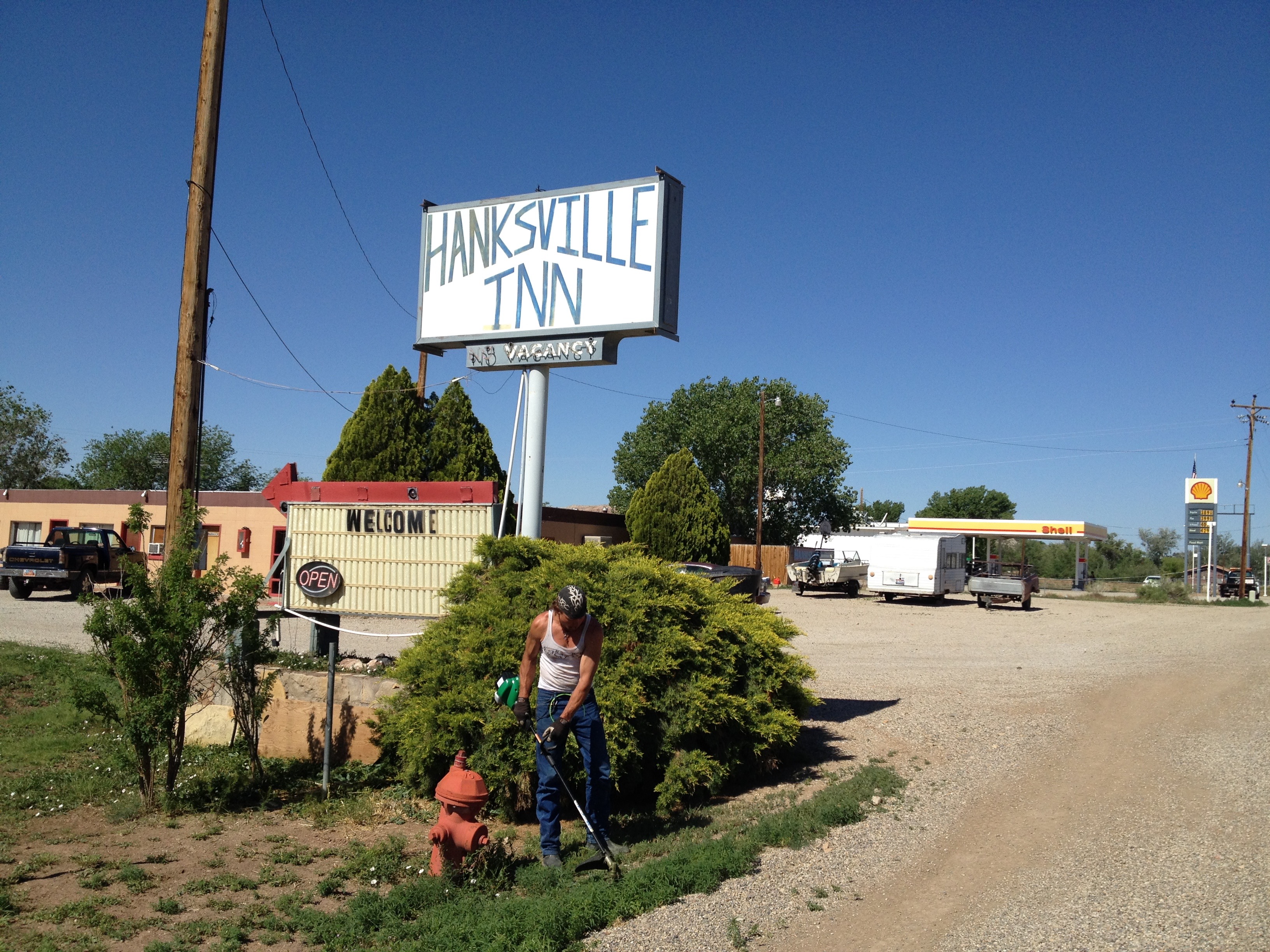
I continue south on AZ-89, through the former gold mining town of Congress, just a short ride from Wickenburg, elevation 2,050.
Wickenburg, another former gold mining town, is my last overnight stop before arriving in La Quinta tomorrow.
An Austrian named Henry Wickenburg was one of the first gold prospectors here, and the town is named after him. Wickenburg – the city, not Henry – once claimed to be the Dude Ranch Capital of the World.
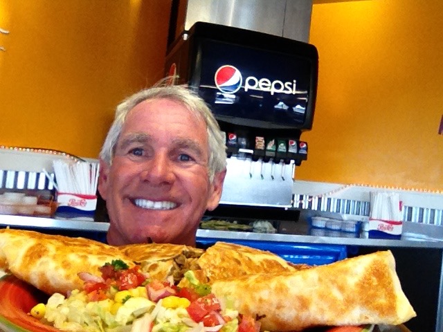
Kung Pao Chicken at the Sizzling Wok in Wickenburg.
Dinner tonight: Asian fare at the Sizzling Wok. Yum. Haven’t had a meal yet on this trip that calls for chopsticks. Tonight’s the night for Chinese.
I have Kung Pao chicken. Scrumptious.
***
Post Script: tonight, Ray is in Conway, Arkansas — not far from Little Rock. He rode 565 miles today and has 537 more to go before pulling in the driveway at his home in Farragut, Tennessee. Ray says he expects to be home tomorrow afternoon. Makes my butt sore just thinking about it.
I, on the other hand, have 275 miles to go before I see Sarah’s smiling face in La Quinta tomorrow.
Note to those of you who are betting Ray will get home first: the smart money is now on the short kid from California. I expect to be home by 1 or 2 tomorrow afternoon.
Mathematically, Ray’s gonna have a tough time edging me out in the “who-gets-home-first sweepstakes.”
Ray actually enjoys the solitude of riding long distances by himself. A large number of his 360,000 miles in the saddle are solo miles.
Some people are cut out for that. Over the past two days of riding — 600 miles over 15 hours — I’ve learned (or rediscovered) that I am NOT one of them.
I simply don’t enjoy the experience of riding alone. In fact, I find it, for me, undesirable.
So, all of you riders and would-be wannabe Harley-ites: who wants to ride with me next year? Yup, that was your invitation.
OK, get off your butt. Stop talking. Start riding. Next year is almost here.
If you have a bike and know how to ride it, great. If not, you’ve got until next summer to figure it out.
***
Day Sixteen Summary: No time for fiddling, a larger-than-life kokopelli, an artsy vibe in Jerome, all ready for the Prescott Bluegrass Festival.
Click here to see today’s complete route from Show Low to Wickenburg.
From Santa Fe, it’s a 730 mile ride to my La Quinta home – and nearly twice as far for Ray to ride to his home in Farragut, Tennessee.
It’ll take me three leisurely days. Ray will probably beat me home. What does that possibly say about me? Be gentle.
After a warm hug, we fire up the big bikes and head our separate ways.
The two amigos say “Adios.”
***
I’m on my own now. Pretty sure I can make it, with the help of some good tunes from playlists I created on my iPod. The music will provide companionship over the next few days through speakers in my helmet.
I head south on I-25 for about 50 miles to Albuquerque, New Mexico’s largest town. Albuquerque, elevation 5,300 feet, straddles the Rio Grande River, and has a population of more than 555,000. It’s home to the University of New Mexico, Kirtland Air Force Base, Sandia National Laboratories, and Petroglyph National Monument.
The city is also home to the Albuquerque International Balloon Fiesta, held annually in October. The nine-day event is one of the city’s largest tourist attractions, drawing more than 700 hot-air balloonists from all over the world.
It’s the world’s largest balloon festival. The event began in 1972 as the highlight of a 50th birthday celebration for local radio station KOB.
Albuquerque hosts the world’s largest balloon festival.
Albuquerque seems to bring out good things in music. Glen Campbell began his career here playing guitar in his uncle’s band in the 1950s. Pop singer Demi Lovato was born here. And, R&B singer Bo Diddley spent many of his later years living in Albuquerque. Click here to watch him sing “Who Do You Love?”
None of those artists has a place on my Harley music collections, so I bypass Albuquerque, turn west onto I-40, and head for Grants, about 75 miles to the west. I-40 here is actually part of the old Route 66, which I talked about on Day 1 of this ride, two weeks ago. Time flies.
***
After a record-setting (for me) 128 miles of Interstate Highway riding, I arrive in Grants. I normally avoid Interstates like the plague, but today, there’s no other way west. My issue with Interstates is not danger; it’s the visual boredom.
Grants, a former logging town, was known as America’s “Carrot Capital” in the mid 20th century. Holtville, California, now claims the same distinction. It’s unclear how that tie will be broken.
Creation of the Bluewater Reservoir helped develop agriculture in the area, and the region’s volcanic soils provided ideal conditions for farming. Beyond its carrot moniker, Grants is also home to a mining museum, which is next to Historic Route 66. The uranium mining boom here lasted until the 1980s, when the collapse of mining nearly ruined the town’s economy.
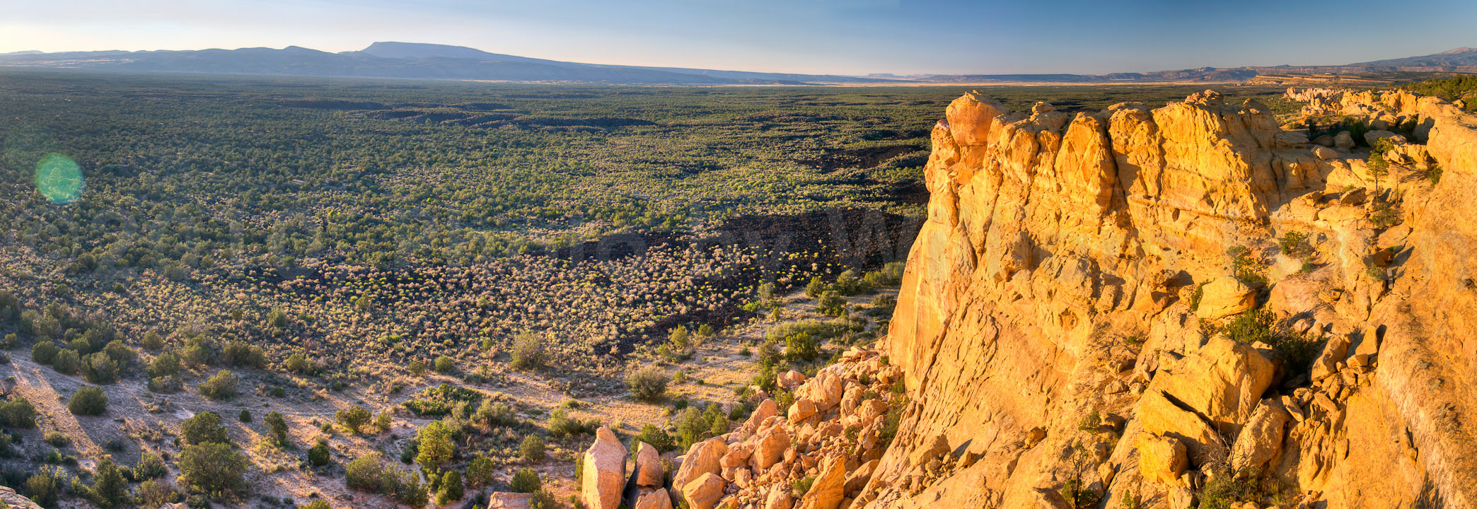
A panoramic view of the El Malpais National Conservation Area.
In Grants, I turn off I-40 / Route 66, and head south on NM-53 toward El Malpais National Monument and El Malpais National Conservation Area. The name El Malpais is from the Spanish term, malpais, meaning badlands. Malpais describes the extremely barren and dramatic volcanic field that covers much of the park’s area.
The road takes me through incredibly desolate areas. If I ran off the road, nobody would find me for weeks. I pass almost no vehicles for an hour or more.
When there is civilization along the roadside, it’s usually dilapidated Indian housing and commerce. Where there is life, there is poverty.
One such place I ride through is Zuni, on the Zuni Indian Reservation. It’s a dusty, barren town that reminds me of the isolation of so many Indian reservations.
I follow NM-53 west toward the state border, where it becomes AZ-61 when we enter Arizona.
As I cross the state line, it is immediately obvious the roads are far better maintained in Arizona. As I leave New Mexico, my personal impression is that it’s nickname could easily be changed to “Land of DIS-enchantment.” Just my opinion.
***
The road continues south to St. Johns, where I turn west toward Show Low, elevation 6,345 feet – tonight’s destination.
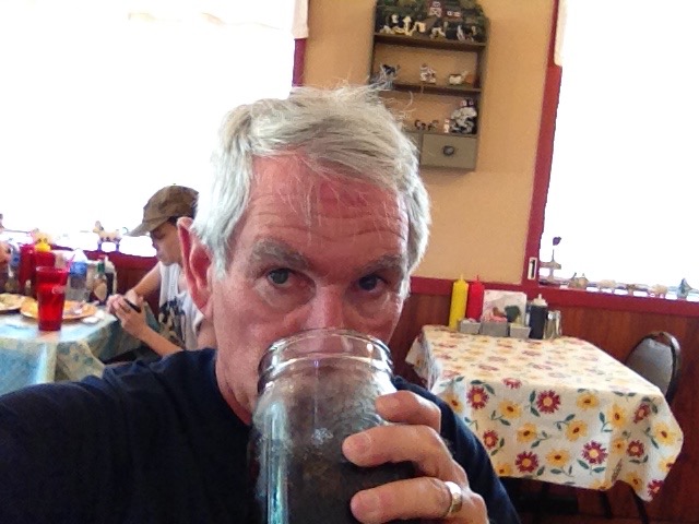
Having a diet coke at TLC’s in St. John’s. Man, am I thirsty!
But first, after several hours of riding in mid-80 degree temperatures, I stop in St. John’s at TLC’s Family Kitchen. I get a large diet coke, my idea of proper hydration on a very hot, dry day.
Contrary to what you might think, riding a Harley on a hot day is not the least bit refreshing. It feels like riding in a blast furnace. Can’t wait to ride into La Quinta Saturday when it’s 110, or whatever!
Forty-five minutes later, I roll into Show Low.
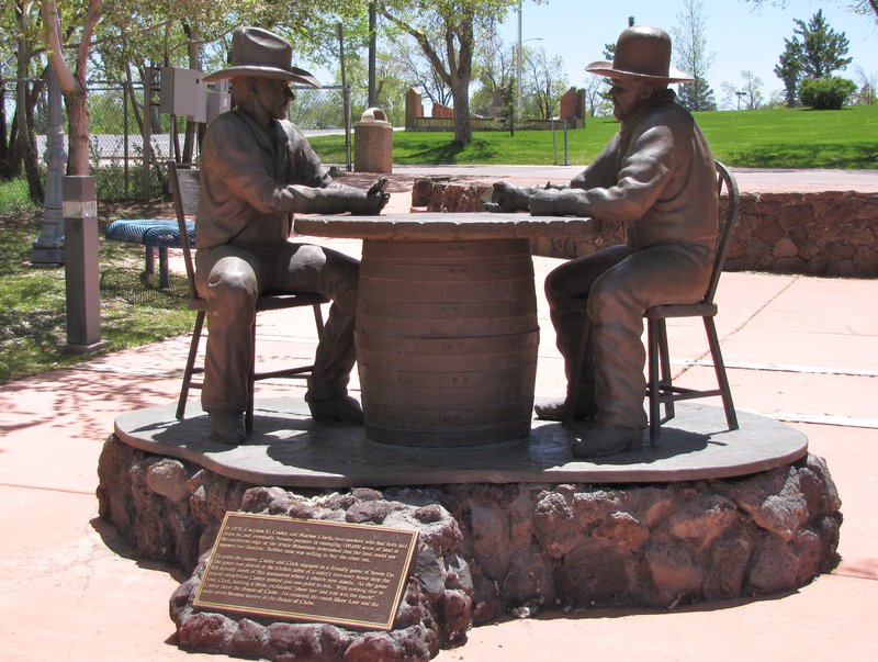
According to the legend, Show Low was named after a marathon poker game between Coryden Cooley and Marion Clark in 1875. The two men decided there was not enough room for both of them in their settlement, so they agreed to let a game of cards decide who was to move.
The game was played in the kitchen of Cooley’s home.
As the tale goes, Clark said, “If you can show low, you win.” Cooley turned up the deuce of clubs (the lowest possible card) and replied, “Show low it is.”
As a result, the ranch became Cooley’s. The poker game is memorialized in a statue that fairly epitomizes the Show Low name.
A monument honoring the manner in which Show Low became Show Low.
A quick aside: I never did gamble. Always called it a “tax on stupidity.”
Show Low’s main street is appropriate to the city’s naming. My hotel is on West Deuce of Clubs. Seriously.
Notable residents of Show Low include:
Mike Furyk, father of PGA Tour golfer Jim Furyk. Mike was a golf pro at several clubs in Pennsylvania, and is credited with teaching golf to his son, Jim, who has won nearly $57 million with a club in his hands. Click here to see the somewhat unorthodox swing Jim perfected under Mike’s guidance.
George Takei, actor from the TV series, Star Trek, where he played Hikaru Sulu, helmsman on the USS Enterprise. Takei lives in Show Low with his husband, Brad. Make it so.
Doug Mathis, major league baseball pitcher who’s struggled to stay relevant in recent years, and was last seen throwing in the Tampa Bay Rays’ minor league system. He attended Show Low High School.
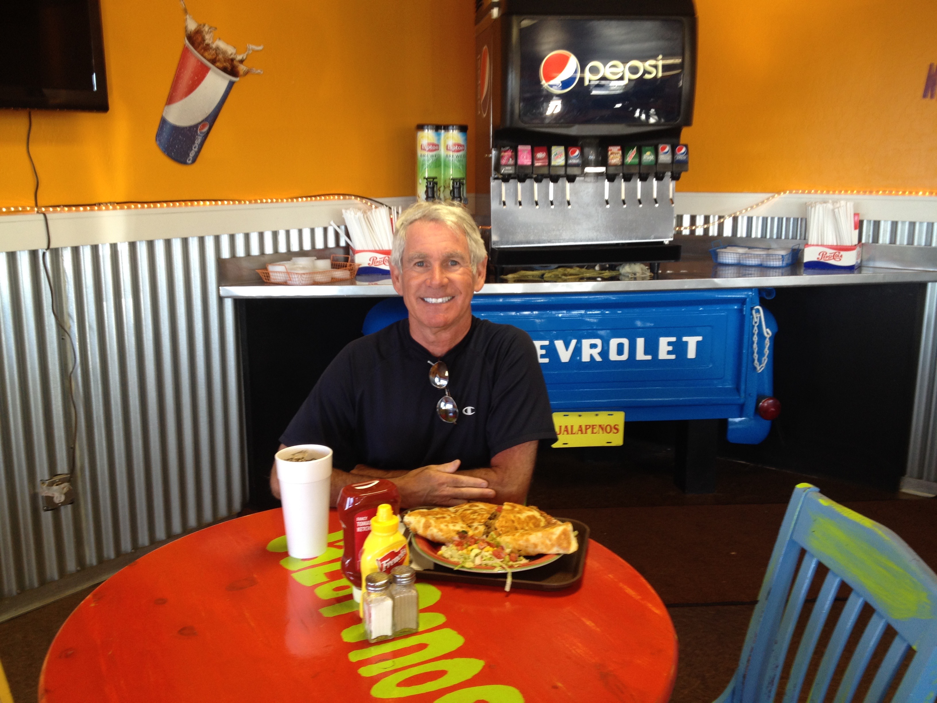
In Show Low, the best restaurants are Mexican. I’m all in for a monster quesadilla.
A monster quesadilla at Jalapeños Cafe in Show Low.
So I go to Show Low’s top-rated Mexican cantina: Jalapeños Cafe. Yum.
Jalapeños is actually the top restaurant, of any kind, in Show Low — according to Yelp. It’s number two on Trip Advisor. It has richly earned all the kudos coming its way.
Owners Brad and DeAnna Crabtree cook my custom quesadilla to order, with tender loving care. All the ingredients are fresh (their slogan: “Keep it Fresh”).
I’ve gotta say: this is by far the best, most original, most creative quesadilla I’ve ever tasted. Sarah, who fancies herself a quesadilla connoisseur, would love this place. Note to self: plan a road trip, non-Harley variety, that includes Jalapeños and Sarah in the same sentence.
Tonight’s dinner turns out to be the best meal I’ve had in 15 days on the road!
I can’t believe I ate the whole thing!
***
Post Script: just heard from Ray. He made it safely to Amarillo, Texas, where he’ll stay tonight. Ray’s ride was 280 miles; mine was 310. Still a toss-up who will get home first. If I were a betting person (you know I am not), I’d put my money on the short kid from California 🙂
***
Day Fifteen Summary: Happy trails Ray, listening to my Harley playlist, the best quesadilla on the planet, a Deuce of Clubs city.
Click here to view today’s route from Santa Fe to Show Low.
Today marks my last day riding with Ray. On this trip.
We begin by turning the Million Dollar Highway into a Two Million Dollar Highway by riding it a second time. Today, we ride the highway south to Durango, in the opposite direction of yesterday’s travel.
We leave Ouray early — about 7:30 — to make sure we clear the under-construction section of the Million Dollar Highway before it closes for the day. If we oversleep, the alternate (detour) route takes us 85 miles out of our way!
As we ride out of Ouray, it’s about 35 degrees, and by the time we reach Red Mountain Pass (11,018 feet), the temperature has dropped to about 20 degrees.
We are freezing our butts off.
Stopping for a warmup at the Brown Bear Cafe in chilly Silverton.
It wasn’t nearly this cold when we summited Mount Evans (14,000 feet+) a few days ago. With frozen hands and teary eyes, we stop in Silverton, about 22 miles from Ouray, for a warm-up at the Brown Bear Cafe.
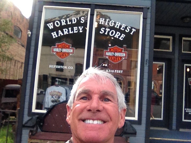
There are quite a few bikers here, all with the same idea. We finally warm up, and leave Silverton about 9:15, after goofing off next door in the Silverton Harley store, the world’s highest.
It’s 70 miles from Ouray to Durango, where we turn east on US-160 and head for Pagosa Springs, 55 miles from Durango.
Pagosa Springs sits at 7,126 feet, and is about 35 miles north of the New Mexico border. “Downtown Pagosa Springs” was the final destination for two truckers in the 1975 country song, “Wolf Creek Pass,” by C.W. McCall. US-160, which drops about 5,000 from Wolf Creek Pass (elevation 10,857) to the town of Pagosa Springs, is described in the song as “hairpin county and switchback city.”
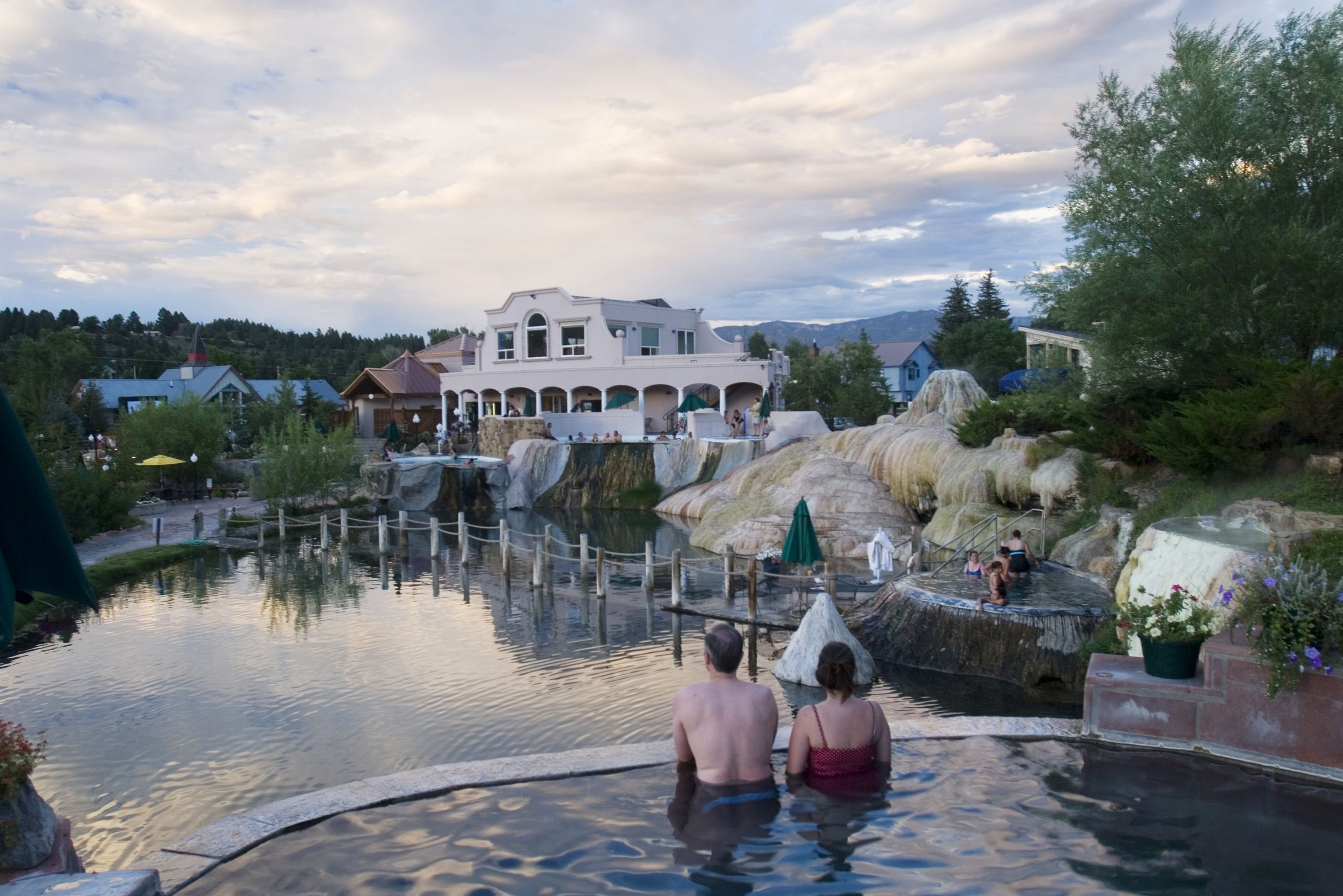
Chillin’ out at the Pagosa Springs Resort & Spa.
A highlight in Pagosa Springs is the Springs Resort & Spa, an upscale spot to relax along the San Juan River. Its hot spring is listed in the Guiness Book of World Records as the world’s deepest geothermal hot spring, unofficially measured at a depth of more than 1,002 feet. Country Living magazine named the Springs Resort & Spa one of its five relaxing and affordable spa vacations.
The Spa calls itself a destination curative resort, specializing in AquaZen Therapy. Aqua Zen? Stay with me on this one. The Spa says therapeutic soaking in the hot mineral springs uses the combination of salt, sulfur, zinc, magnesium and lithium to pull the toxins from the soft tissues of the body. It’s a bit New Agey for my tastes, but who am I to judge? If it feels good, do it.
***
From Pagosa Springs, we ride south on US-84 toward New Mexico, and in 127 miles, we are in Espanola, New Mexico.
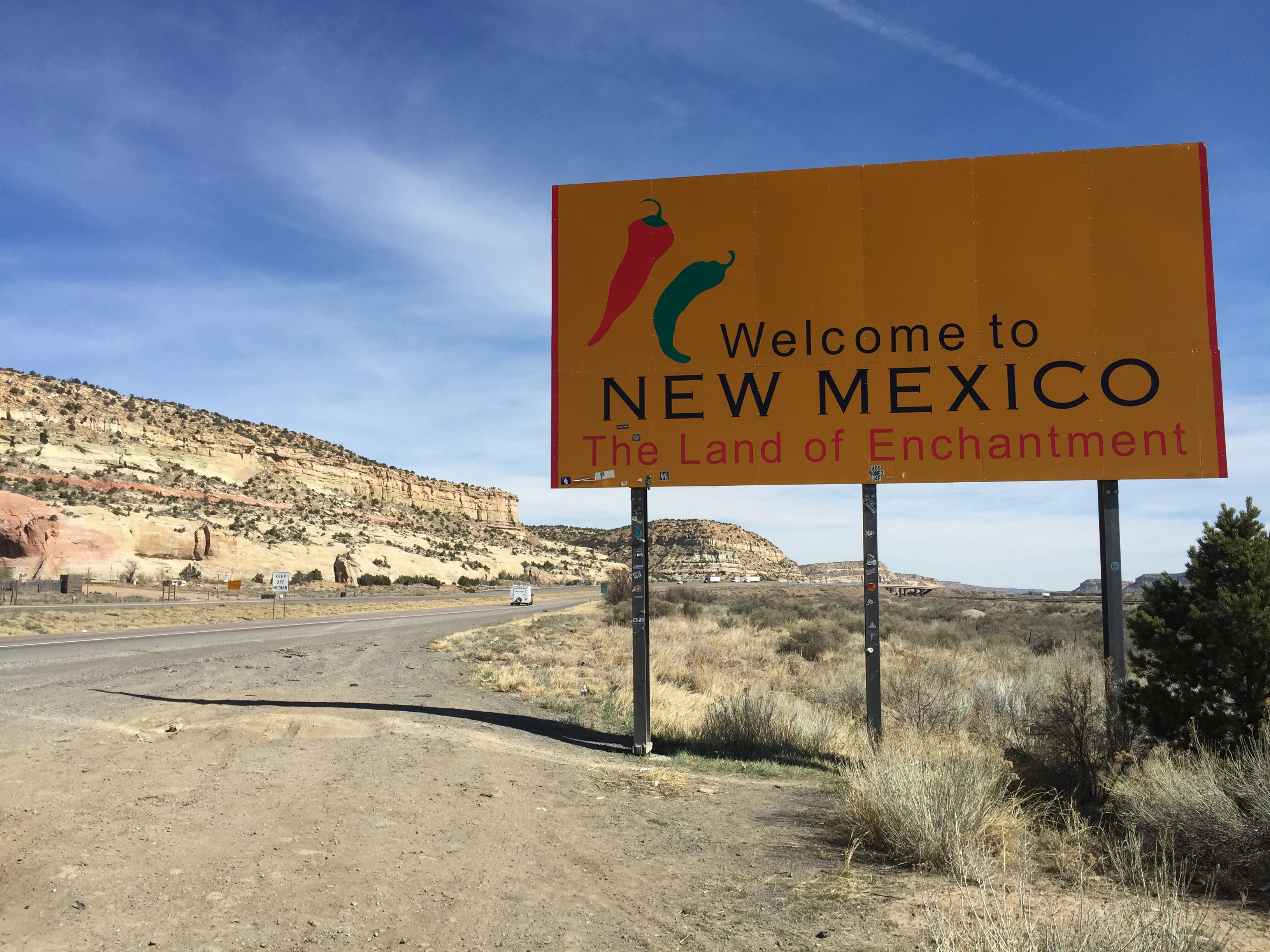
New Mexico calls itself the Land of Enchantment. Congress admitted New Mexico as the 47th state, on January 6, 1912.
A few hours in New Mexico, but it didn’t feel all that enchanting.
The state, with a large Hispanic population and cultural influence, is known, in Spanish, as Nuevo Mexico. Almost half of New Mexicans claim Hispanic origin. But New Mexico did not take its name from the nation of Mexico. New Mexico was given its name in 1563 by Spanish explorers who believed the area contained wealthy Indian cultures similar to those of the Mexica (Aztec) Empire.
Nearly 29 percent of the New Mexico population aged 5 and older speak Spanish at home. Another 4 percent speak Navajo. With 16 million acres, mostly in neighboring Arizona, the reservation of the Navajo Nation is the largest in the U.S.
***
Espanola translates in Spanish to “someone or something from Spain.” Espanola was originally called “La Espanola,” because of the large presence of Spanish women in the area.
We roll through Espanola, mostly unaware of its historic importance. Espanola was originally settled in 1598 by the Spanish, in what was the first permanent European colony in North America. But the area’s more recent history is what really put it on the map.
Espanola’s largest employer is the Los Alamos National Laboratory in Los Alamos, at 7,300 feet above sea level. It employs more than 12 percent of the Espanola population. As we pass through Espanola, the Los Alamos facility is off in the distance to our west. But even though we don’t stop and visit, it’s worth a mention.
The Los Alamos National Laboratory has been a popular, and very secret, spot for decades.
Los Alamos is the largest employer in northern New Mexico, with nearly 10,000 employees. It’s one of the largest science and technology institutions in the world, conducting research in national security, space exploration, renewable energy, nanotechnology and supercomputing.
About one-third of the laboratory’s technical staff members are physicists, one quarter are engineers, and the remainder are chemists, materials scientists, mathematicians and other really, really smart people. The facility’s annual budget is more than $2 billion.
The Los Alamos laboratory was founded during World War II as a secret facility to coordinate the scientific research of the Manhattan Project, the U.S. effort to develop the first nuclear weapons. Another Manhattan Project site was in Oak Ridge, Tennessee, where Ray Sanders later worked.
***
In 1942, Lt. General Leslie Groves was in charge of the Manhattan Project. He was looking for a central laboratory at an isolated location. The remote site would enhance safety, and keep the scientists away from the local populace. Groves, an officer with the U.S. Army Corps of Engineers, previously oversaw construction of the Pentagon. He knew how to get big things done, and now needed an ultra-secret location to develop an atomic bomb.
Meantime, Manhattan Project scientific director J. Robert Oppenheimer had spent much of his youth in the New Mexico area, and suggested the Los Alamos area would make a fine spot. Oppenheimer turned out to be right.
This odd-looking thing was called “Gadget.” It was detonated as part of the 1945 Trinity nuclear testing.
The Manhattan Project, at all its locations, operated under a blanket of tight security and unprecedented secrecy. The Los Alamos location was a total secret. Its only mailing address was Post Office Box 1663 in Santa Fe, the state capitol 35 miles away.
The work of the laboratory culminated in the creation of several atomic devices, one of which was used in the first nuclear test near Alamogordo, New Mexico. The July 1945 test’s code name was “Trinity.”
The other two nuclear weapons produced at Los Alamos were “Little Boy” and “Fat Man,” used in the attacks on Hiroshima and Nagasaki, which ended World War II.
***
From Espanola to Santa Fe, it’s about a 30-minute ride, mostly on US-84.
Santa Fe is the oldest capital city in the US. Santa Fe means “holy faith” in Spanish. Its sister cities include Santa Fe, Spain; Holguin, Cuba; and Livingstone, Zambia.
We arrive in Santa Fe, and it’s 87 scorching degrees — almost 70 degrees warmer than when we crossed Red Mountain Pass this morning. We are baking!
The pueblo style architecture seen in Santa Fe looks right at home in New Mexico.
Santa Fe has a large, artistic community – with thriving colonies for artists and writers. Every August, the city hosts the annual Santa Fe Indian Market, the oldest and largest juried Native American art showcase in the world.
Notable residents of Santa Fe include:
Gene Hackman, 84-year-old actor known for films including The French Connection, Unforgiven, Crimson Tide, and Get Shorty. His wife, Betsy, owns an upscale retail home furnishings store in Santa Fe called Pandora’s.
Randy Travis, country music singer and actor, known for his distinctive baritone vocals. Travis has sold more than 25 million records, had 22 number one hits, six Grammy awards and a star on the Hollywood Walk of Fame.
William Berra, a painter of landscapes and still life. His work is shown at galleries throughout the U.S. He’s been in Santa Fe since 1976, spending much of his time painting Northern New Mexico plein air, a fancy term meaning painting outdoors.
Cormac McCarthy, novelist, playwright and screenwriter who won the Pulitzer Prize for fiction in 2006 for The Road. His 2005 novel, No Country for Old Men was adapted as a 2007 film of the same name, which won four Academy Awards, including Best Picture. Click here to watch the trailer for No Country for Old Men.
Ray and I are residents of Santa Fe for the next 12 hours.
A great ending to a great ride.
Tonight, we celebrate our Ride in the Rockies, which officially ends in Santa Fe, elevation 7,260 feet.
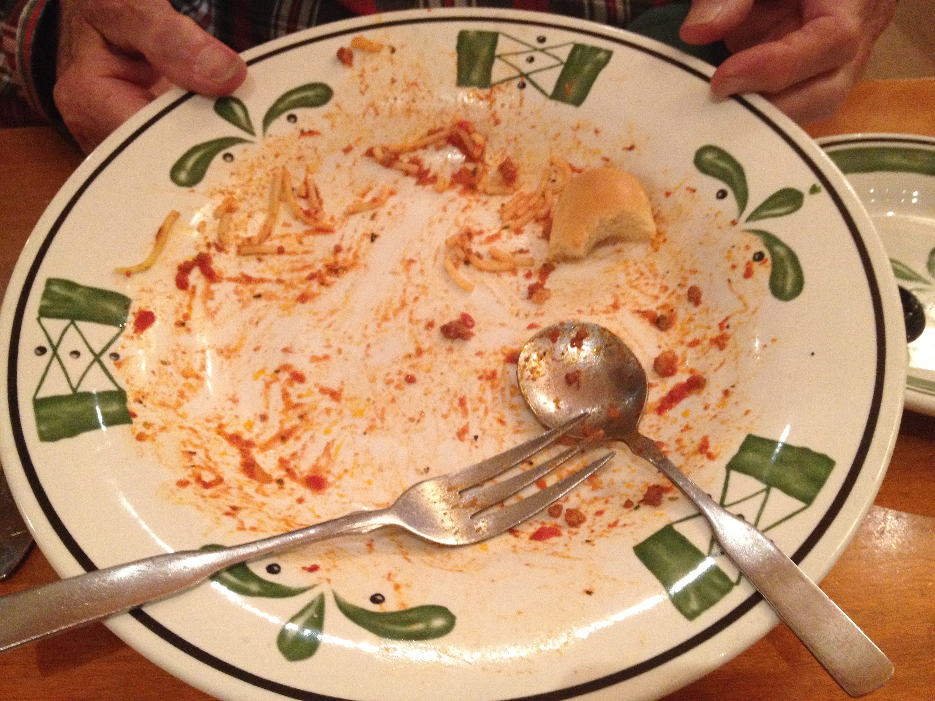
We dine at the Olive Garden, a bookend experience: on the first night of our first trip together in 2009, we ate at the Olive Garden in Victorville, California.
So it seems fitting, at the end of our fifth ride, five years later, we close out our journey together at the Santa Fe Olive Garden.
And, wouldn’t you know it: Ray has the identical meal he had in 2009. He orders spaghetti and a glass of Merlot. We are living large on our final night together!
In the morning it’ll be time for me to head west to La Quinta, and for Ray to turn eastward toward Tennessee.
As usual, Ray orders spaghetti, and devours it.
It’s a bittersweet dinner for Ray and me, knowing we won’t ride together again until next year. We recall fondly the trip’s highlights. As you might expect, Rocky Mountain National Park is at the top of the list. So is Mount Evans.
***
Day Fourteen Summary: A two-million dollar highway, hairpin county and switchback city, smart people by the boatload, no country for old men.
To view today’s route from Ouray to Santa Fe, click here.
Today, we’ll make one final loop through the San Juan Mountains and San Juan National Forest, before returning to Ouray for a second night.
We begin the day by riding 10 miles north to Ridgway, then turning southwest on CO-62 for 23 miles toward Placerville, originally established as a small mining camp. Placerville was named after the placer gold mines located on the San Miguel River and Leopard Creek. For you non-miners out there, placer mining is the mining of alluvial (loose) deposits for minerals.
There’s not much in Placerville these days, though it does have a U.S. Post Office, with an 81430 ZIP code.
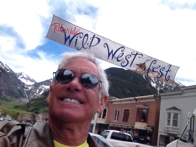
In Placerville, we turn east on CO-145, and 15 miles later, we are in the mountain town of Telluride, famous for skiing in the winter and its many festivals in the summer. Telluride sits in a box canyon, at 8,750 feet.
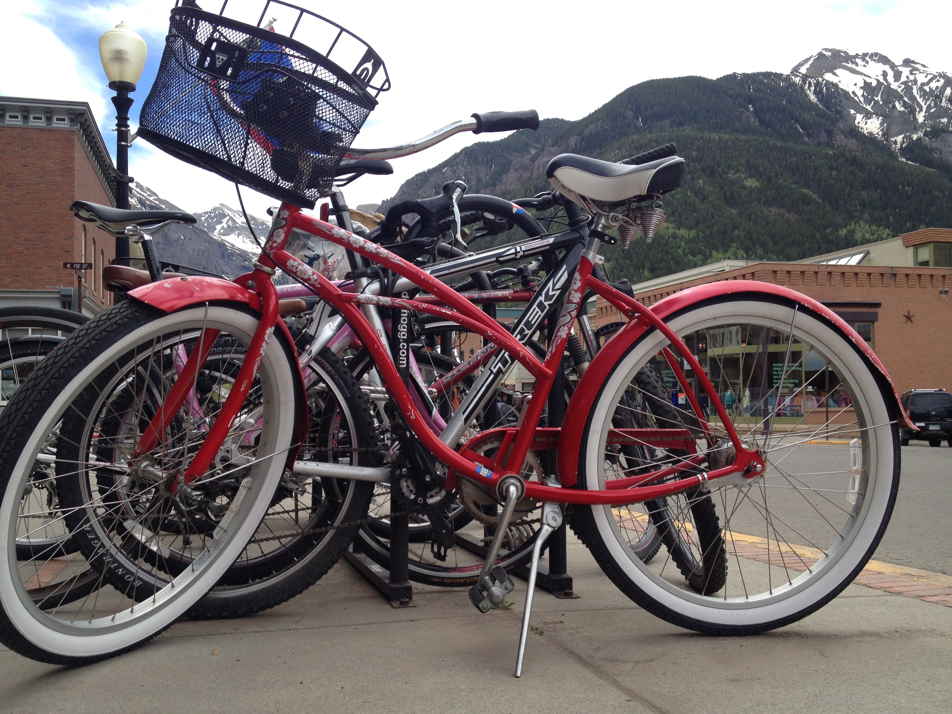
Bicycles on parade in Telluride.
Telluride is a former silver mining camp, founded in 1879 as “Columbia.” But due to confusion with a California town of the same name, it was renamed Telluride in 1887, for the gold telluride minerals found in other parts of Colorado. A telluride mineral has the telluride anion as a main component. Consult someone with a chemistry or mining background for a better explanation.
Gold tellurides include calaverite and krennerite. These telluride minerals were never located near Telluride, causing the town to be named for a mineral that was, um, never mined there.
Mining was Telluride’s only industry until 1972, when the first ski lift was installed by Telluride Ski resort founder Joseph Zoline and his Telluride Ski Corporation. The town of Telluride sits at 8,750 feet in the western San Juan Mountains.
In the 1980s, Telluride became notorious in the drug counterculture for being a drop point for Mexican smugglers and a favorite place for wealthy importers to enjoy some downtime.
Wild West Fest is coming up.
The town was featured in the 1985 NBC-TV hit show Miami Vice, courtesy of Glenn Frey’s song, “Smugglers Blues.” Among its lyrics: “They move it through Miami, sell it in L.A. They hide it up in Telluride, I mean it’s here to stay.” Click here to time travel back to the ’80s and hear/watch Smuggler’s Blues.
Frey, a member of The Eagles rock band, has a home at PGA West, where his mother lived for many years until her death in 2013. He’s also owned high-end properties in Hana, Hawaii; Brentwood, California; and Snowmass, Colorado.
Country singer Tim McGraw in 2001 recorded his song, “Telluride,” which included the lyric: “In Telluride, the snow falling down, I was waking up in that sleepy little town. In her eyes my world came so alive. I never will forget the moment she arrived in Telluride.” To see Tim McGraw’s vision of Telluride, click here.
Local residents and visitors have included Bob Dylan, Daryl Hannah, Jerry Seinfeld, Ed Helms, Sean Penn, Oprah Winfrey and Tom Cruise. All rich and famous. Just like in Aspen.
***
Feeling somewhat rich and famous ourselves, if only by association, we hop on our bikes and continue south on CO-145 for 60 miles, to the town of Dolores. For you etymology fans, Dolores is Spanish for “sorrows” and is named for the river on which it’s located. Dolores is at the southern end of the McPhee Reservoir.
Summer is road construction season, as we found on Highway 145.
In Dolores, we turn east on CO-184, heading for the town of Mancos, whose most notable resident is Luther Elliss, former NFL football player for the Detroit Lions, who once played at the University of Utah (“America’s Team”). Elliss was born in Mancos, attended Mancos High School, and played for the Mancos Blue Jays high school football and basketball teams. The guy has some real Mancos roots.
From Mancos, we turn east on US-160 and 27 miles later we are in Durango, which is named after Durango, Mexico – which was named after Durango, Spain. All three Durangos are sister cities. The word Durango originates from the Basque word “Urango,” meaning “water town.”
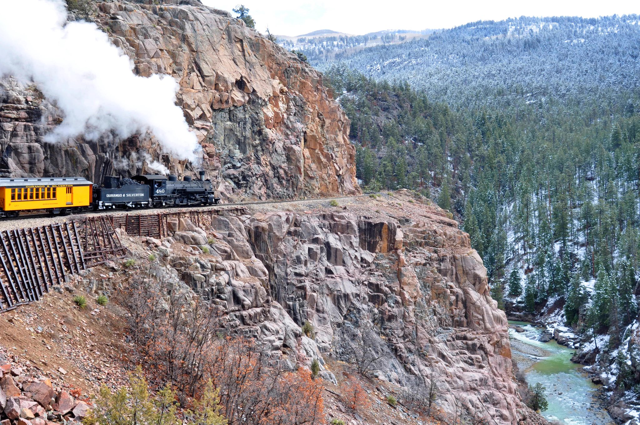
Durango sits on the Animas River at an elevation of 6,500 feet. Durango was founded by the Denver & Rio Grande Railway in 1879. The railroad arrived in 1881, constructing a narrow gauge line to haul passengers and freight to Silverton – and to haul silver and gold ore from the San Juan Mountains.
Taking the train from Durango to Silverton offers breathtaking scenery.
The historic train has been in continuous operation since 1882. For $85, you can board in Durango for the 3 ½-hour, 45-mile ride to Silverton. There, you’ll relax for 30 minutes before the return trip begins. The train’s top speed is 18 miles an hour.
Durango is also home to the SnowDown Festival, a historic downtown district, and Fort Lewis College.
My good friend, Curtis Smith, a Shell Oil PR exec originally from Soldotna, Alaska, once attended Fort Lewis College, where he was a walk-on player on the golf team. Curtis, part of the annual Alaska golf invasion to La Quinta, now works for Shell in the Washington DC area.
I exchanged email notes today with Curtis, who is in The Hague, The Netherlands — Shell’s international headquarters. That’s way more cool than Boeing sending me to Chicago. Chicago, however, does have better pizza than whatever Curtis is eating in The Netherlands.
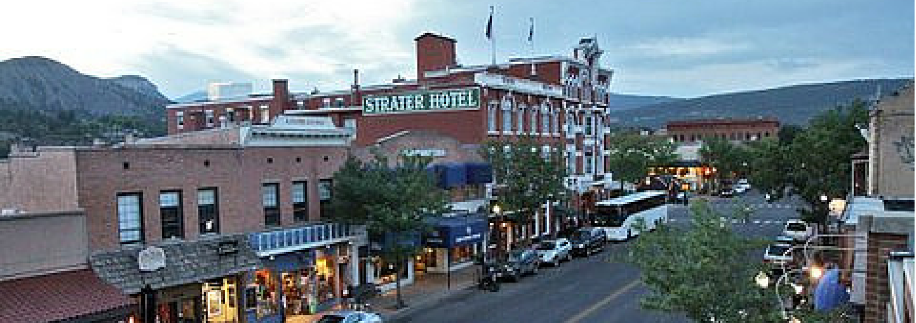
Historic downtown Durango.
Other notable people with a Durango connection include:
Bob Roll, former bicycle racer and one-time Lance Armstrong training partner, who now broadcasts major cycle races, including the Tour de France. You can see how Bob rolls when “le Tour” begins Saturday, July 5, on the Versus and NBC Sports Networks.
Steve Carlton, former Major League baseball pitcher, who won four Cy Young awards for the Philadelphia Phillies before retiring to Durango.
Louis L’Amour, western author who wrote his Sackett Series at the historic Strater Hotel in downtown Durango.
Jack Dempsey, boxer who became the world heavyweight champion in 1919. Dempsey won one of his first fights in a 10-round boxing match at Durango’s Central Hotel.
Parts of the 1991 film, City Slickers, were filmed here. Best line from that movie: “We’re lost, but we’re making good time.” The line was originally attributed to Yogi Berra, long noted for his malapropisms.
***
Leaving Durango, we head north on US-550, which will take us all the way to Ouray, 70 miles to the north.
About 25 miles from Durango, we pass by the Durango Mountain Resort, sometimes known by its former name, Purgatory. The name Purgatory comes from Purgatory Creek, which runs through the area – and from Purgatory Flats, today the location of the ski area’s base. The ski resort’s base is at 8,793 feet; its peak is 10,822 feet.
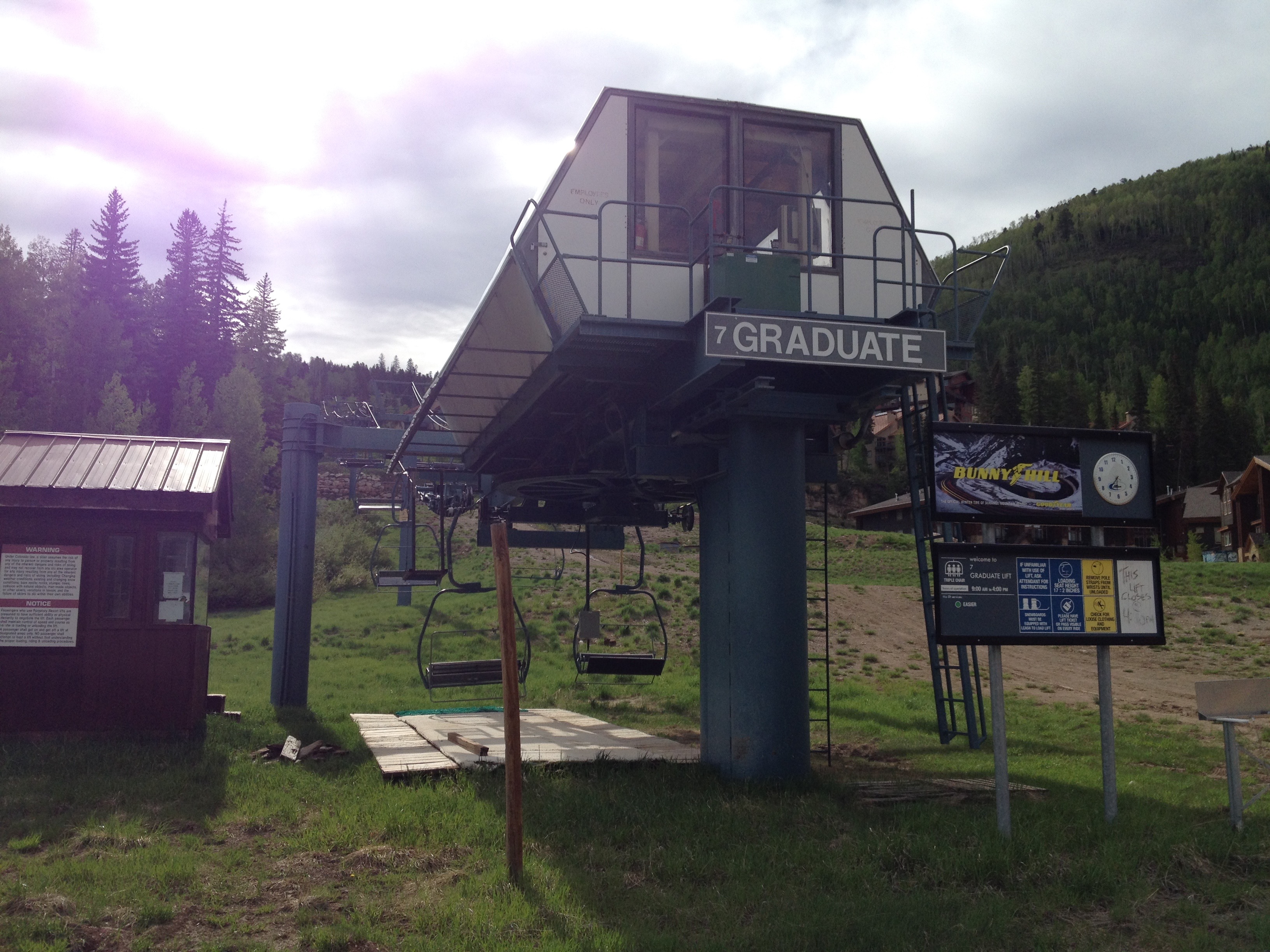
Durango Mountain Resort: no skiing today.
Legend has it that the Purgatory name comes from miners who were trying to get from Durango to the prosperous mines in the Silverton area. They had to pay 50 cents to use the toll road. Miners who couldn’t afford the toll were stuck in the area, which became known as Purgatory Flats. They couldn’t afford to get up the mountain, but couldn’t see themselves quitting and going down, either. Now that’s purgatory.
We continue north on US-550 to Silverton, a former silver mining camp, now designated a National Historic Landmark District.
Silverton, at 9,308 feet, was the setting for some of snowboarder Shaun White’s 2010 Winter Olympic training. Taking advantage of the secluded locale, terrain and snowfall, Red Bull (one of his sponsors) built White a private halfpipe on the backside of Silverton Mountain. The Flying Tomato went on to win the 2010 halfpipe gold medal at Cypress Mountain, near Vancouver B.C., a repeat of his gold-medal performance at the 2006 Winter games in Turin, Italy.
Click here for a fun look at White’s private halfpipe in Silverton.
***
The world’s highest Harley store, in Silverton, elevation 9,308 feet.
From Silverton, the remaining 25 miles of US-550 are quite a thrill. This road, part of the San Juan Skyway Scenic Byway, is known as the Million Dollar Highway.
Though the entire stretch from Silverton to Ouray earns the Million Dollar designation, it’s really the 12 miles from Ouray through the Uncompahgre Gorge to the summit of Red Mountain Pass where the highway gets its name.
The road has steep cliffs, narrow lanes, hairpin curves, and few guardrails. My sphincter is tightening up just thinking about it.
The Million Dollar Highway goes over three mountain passes: Coal Bank Pass (10,640 feet), Molas Pass (10,970 feet), and Red Mountain Pass (11,018 feet).
It’s unclear exactly where the Million Dollar Highway gets its name. Two popular legends for its name:
It cost a million dollars per mile to build the roadway in the 1920s
Its fill dirt contains a million dollars in gold ore
Pick one, or make up something slightly more creative.
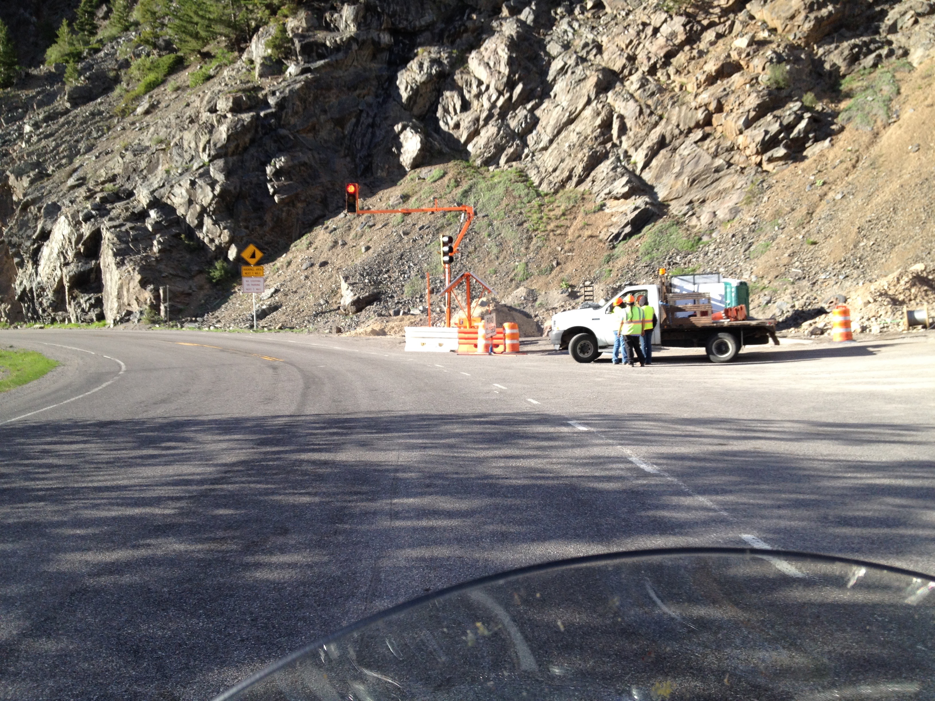
A funny thing happens on our way to Ouray: the road is closed!
Well, this is something new: a signal on the Million Dollar Highway, just a few miles from Ouray.
OMG … The Colorado Department of Transportation has closed a mile-long stretch of the Million Dollar Highway, about three miles from Ouray.
The road is closed to all traffic from 8:30 am to 6:30 pm. The DOT is doing rock scaling and “rockfall mitigation” — cleaning up after a super-sized slide over the winter.
We arrive at the closure point about 6:45 pm, and the closed section of road is now open, one lane at a time — when the signal on your direction turns green.
We wait on the red light a few minutes. Then it turns green, and we ride the last few miles into Ouray as the sun sets over the mountains.
Tomorrow we’ll head south out of Ouray on the Million Dollar Highway. We’ll be setting our alarm clocks tonight, knowing if we oversleep, the road will be closed and we may stay in Ouray until it reopens tomorrow night!
***
Day Thirteen Summary: Smugglers blues in Telluride, a lesson in mining chemistry, we’re lost but we’re making good time, a million dollars for the taking.
To see today’s complete route from Ouray to Durango and back to Ouray on the Million Dollar Highway, click here.
Today, we begin heading home. Or at least riding south.
But there’s still much to see along the way. We’ll spend several more days in the Rockies before we even begin thinking about La Quinta (a few feet below sea level), and Farragut, Tennessee – 883 feet above sea level. Both seem so far away right now.
***
Riding 12,000-foot passes on a Harley is addicting. We got an adrenaline high yesterday on Trail Ridge Road, as we climbed to 12,183 feet near Fall River Pass. So, what the heck, let’s see if we can bag another 12,000-footer this morning.
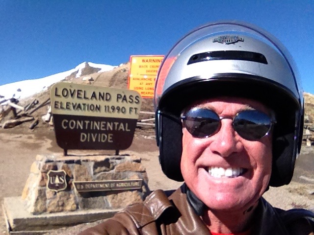
Loveland Pass, just a shade under 12,000 feet.
Wouldn’t you know it, we’re only 20 minutes from Loveland Pass, which, at 11,990 feet, is certainly close enough to be considered a twelve-er.
So we jump on I-70, head east for 10 miles, then turn south on US-6 – and in 4 miles, we are at Loveland Pass. It’s not far from the Loveland Ski area, where 2014-15 season passes are already on sale. Adults can ski the entire season for $379; Seniors (70 ) can get a season pass for $89, and children 5 and under ski for free. Woo-hoo!
For you bicycle enthusiasts, Loveland Pass is one of three passes used in the annual “Triple Bypass” ride, a supreme challenge to test the ultimate fitness of any cyclist. The event, which will be held this year on July 12 and 13, begins in Bergen Park at the junction of CO-74 and CO-103. From there, bikers first climb to 11,140-foot Juniper Pass, before continuing to Loveland Pass (11,990 feet) and on to Vail Pass (10,560), before finishing the 120-mile ride in Avon, just 10 miles east of Vail. The one-day ride has more than 10,000 feet of elevation gain!
If you’re interested, you may be a bit late to start getting in shape – but it’s not too late to register. Click here to learn more about the Triple Bypass, and see how you can sign up. The event is so popular that Saturday’s west-to-east ride is already full – some 3,500 riders are taking up the challenge. But you can still sign up for Sunday’s ride (July 13), which uses the same route, but rides from east-to-west. Super hearty cyclists with a penchant for pain actually ride both Saturday and Sunday; it’s called the Double Triple Bypass!
To read one rider’s first-person account of his Triple Bypass, which he calls “a fun day of suffering,” click here.
Should you try a Triple Bypass? Consult your cardiologist.
***
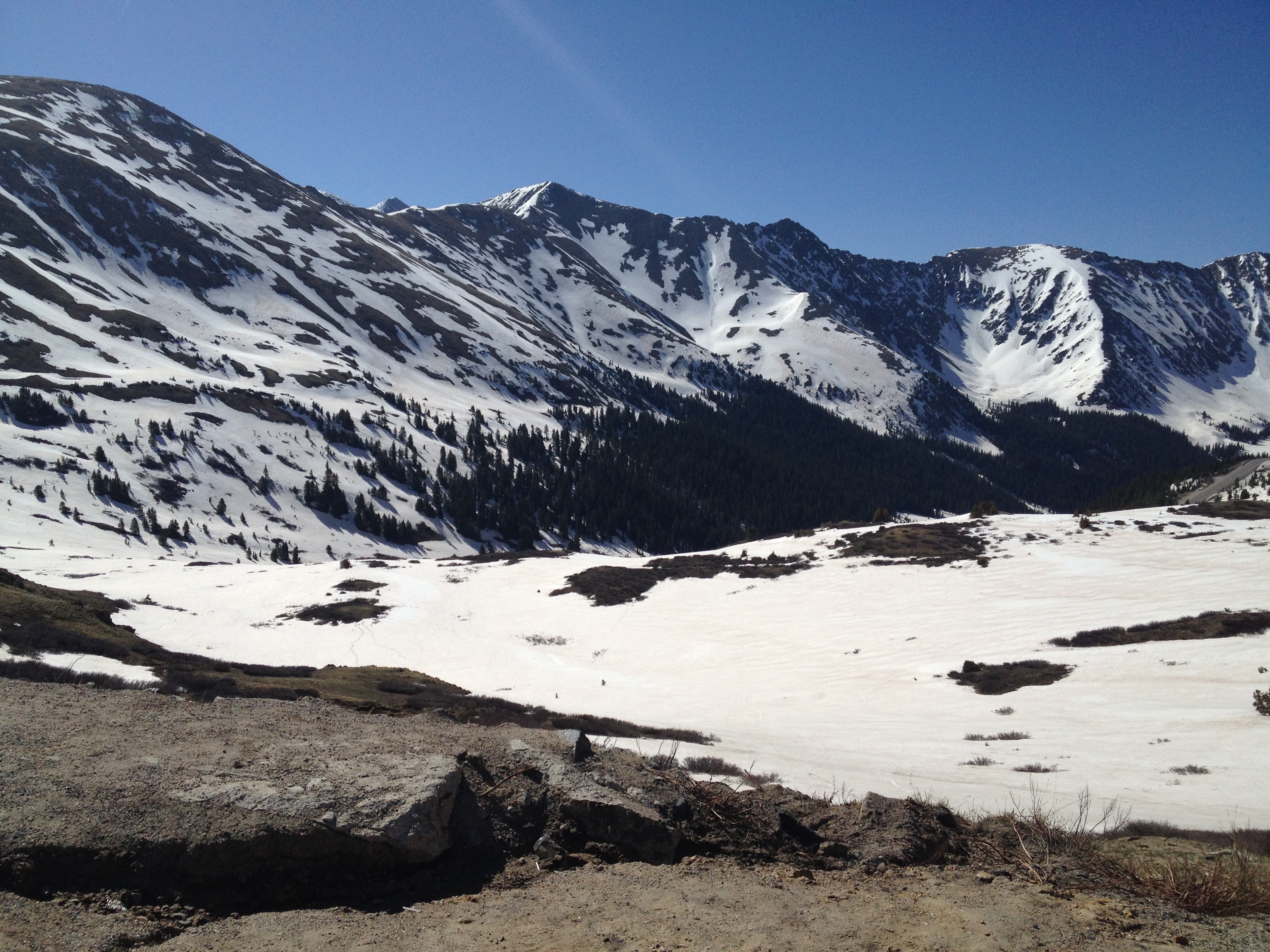
The view at Loveland Pass.
Today, Ray and I only have time for a single bypass – Loveland Pass only – so we press on, following US-6 past a number of well-known Colorado ski resorts, including Keystone, Arapaho Basin, and Breckenridge.
Season passes for the 2014-15 season are on sale at all these resorts.
A few days ago, we passed by the Copper Mountain Ski Resort. It’s worth mentioning that 2014-15 season passes are available here, too. For $389, it comes with three free days of skiing at Killington (Vermont), Park City (Utah), Boreal (California) and Mt. Bachelor (Oregon). Sweet! And for another $100, you can buy Copper Mountain’s new “Secret!” pass, which gets you on the mountain 15 minutes before everyone else, and there’s a dedicated lift line so you can bypass any crowds. Sorta like one of those hotshot airport passes for travelers to avoid TSA hassles.
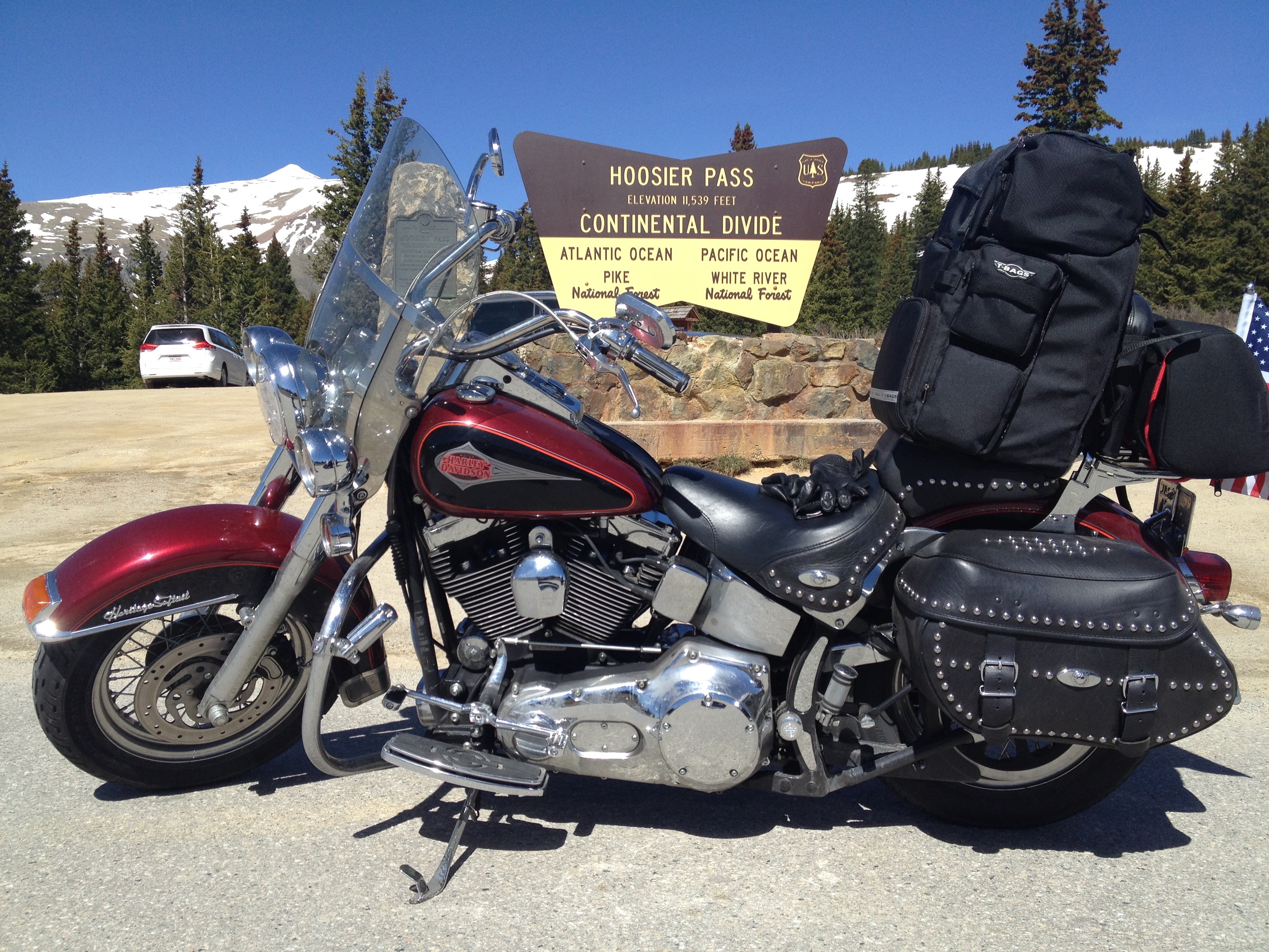
We turn south off of US-6 onto CO-9, which takes us over Hoosier Pass, another Continental Divide crossing.
Hoosier Pass, another crossing of the Continental Divide.
Hoosier Pass, 11,539 feet, is at the northern end of the Mosquito Range. The highway over Hoosier Pass provides an alternate route from Denver to ski areas like Breckenridge and Keystone.
The pass is also the highest point on the TransAmerica Trail, a transcontinental bicycle route that stretches from Yorktown, Virginia, to Astoria, Oregon.
CO-9 leads us to US-285, a scenic road that includes Fairplay, which sits at 10,000 feet. Fairplay is a good place to stop for coffee and a pastry. Not much else going on here.
We continue on US-285, to Poncha Springs, which is at the intersection of US-285 and US-50. Because of its location, Poncha Springs has been dubbed the “Crossroads of the Rockies.”
At this crossroad, we turn west on US-50 and ride about 60 miles to Gunnison, which seems like home now.
The Dillon Reservoir.
Past Gunnison, we ride along the Dillon Reservoir. We stop for a few photos of the Dillon Pinnacles, a unique formation on the south side of the reservoir.
We press on, and ride west on US-50 for another 64 miles, to Montrose, another place we’ve been before on this trip. In Montrose, we turn south on US-550 for the 45-minute ride to Ouray, one of the most spectacular and beautiful mountain towns imaginable.
***
Ouray, which sits at 7,792 feet, is the birthplace of Kathryn McBride, who we stayed with last week in Palisade.
Ouray was originally established by miners chasing silver and gold in the surrounding mountains. Prospectors arrived here in 1875. At the height of mining there, Ouray had more than 30 active mines. It was mining that brought Kathryn’s family to Ouray, where her father sought his fortune.
I love Ouray!
All of Ouray’s Main Street is registered as a National Historic District. Several buildings are listed on the National Register or Historic Places, including the St. Joseph’s Miners’ Hospital, where Kathryn was born. The Hospital now houses the Ouray County Historical Society and Museum.
Today’s Ouray economy is based entirely on tourism. Ouray bills itself as the “Switzerland of America,” because of its setting at the narrow head of a valley, enclosed on three and a half sides by steep mountains. Much of the tourism is focused on ice climbing, mountain biking, hiking and off-roading in the San Juan Mountains.
Ouray is considered the winter ice-climbing capital of the U.S. It has the world’s first ice climbing park, expanding on previously popular natural falls, with dozens of frozen waterfalls from 80 to 200 feet high along more than a mile of the Uncompahgre Gorge. The Ouray Ice Park’s slogan: “Get Your Axe in Gear!”
Click here to check it out – by far, the best video you’ll see in 17 days on this blog.
Ice climbing at Ouray’s Ice Park.
There’s that word again. Uncompahgre. Uncompahgre is a Ute Indian word, which loosely translates to “dirty water” or “red water spring.” It’s believed to be a reference to the many hot springs in the vicinity of Ouray.
The town has inspired literature, film, television and commerce.
In Ayn Rand’s 1957 novel, Atlas Shrugged, the protagonist’s secret hideaway was in a beautiful valley called Galt’s Gulch, which was inspired by Ouray – where Rand completed her novel.
In the TV series MacGyver, Ouray is the home of MacGyver’s grandfather, Harry. The town is used as a backdrop for the first-season episode, “Target MacGyver.”
The opening scene in the movie, Over the Top, with Sylvester Stallone, runs straight through downtown Ouray. The movie was universally panned, but you can still click here to watch the film’s Ouray scene.
And, Coors and Chevrolet have both filmed commercials in the area. Thirsty? Click here to watch the Coors Ouray commercial.
Ouray is also a popular destination for motorcyclists, as it marks the beginning of the Million Dollar Highway, which we will ride tomorrow.
***
Day Twelve Summary: The crossroads of the Rockies, Uncompahgre explained, America’s ice climbing capital, Target MacGyver.
To view today’s route from Silverthorne to Ouray, click here.
As I may have mentioned before, Ray has hundreds of thousands of motorcycle miles in the saddle. He’s ridden 356,000 miles in the U.S. and Canada. He’s been to the Arctic Circle, Europe, Australia. It’s hard to imagine somewhere Ray hasn’t been.
And for years, he’s told me that his favorite place of all is Rocky Mountain National Park, in Colorado. That’s today’s destination. It promises to be the highlight of our trip.
***
We leave Silverthorne and head north on CO-9, riding toward Green Mountain Reservoir, which sits at an elevation of 7,950 feet. The Green Mountain Dam was built between 1938 and 1942 by the Bureau of Reclamation. The dam and reservoir store water to benefit Colorado’s Western Slope, which is pretty much everything in the state west of the Continental Divide.
Green Mountain Reservoir.
The reservoir’s lake is popular with fishermen, who catch rainbow trout, lake trout, brown trout, and kokanee. Green Mountain Reservoir empties into the Blue River, which we follow to the town of Kremmling, just north of the confluence of the Blue River and the Colorado River.
We arrive in Kremmling, elevation 7,313 feet, less than an hour after leaving Silverthorne. Like so many towns in the area, Kremmling was founded during the Colorado silver boom days. The original post office here was called Kinsey City, named after brothers Aaron and Kohn Kinsey, who had a local ranch. The Kinsey City postmaster was Rudolph Kremmling, who ran the town’s general store. In 1895, the town was officially re-named Kremmling.
Kremmling is at the intersection of CO-9 and US-40, once a main east-west route through Colorado. Before the Interstate Highway System, US-40 once traversed the entire country, from San Francisco to New Jersey. Today, US-40’s western terminus is in Utah, not far from Park City. The highway terminates in Atlantic City, two blocks from its famous Boardwalk.
We turn east in Kremmling onto US-40, which follows the Colorado River, running through the towns of Parshall and Hot Sulphur Springs.
Relaxing in a geothermally heated pool in Hot Sulphur Springs.
Hot Sulphur Springs was originally a winter campground for Native Americans who came to use the geothermally heated hot springs for medicinal purposes. If we had more time – and money – we’d stop at the Hot Sulphur Springs Resort & Spa for some soaking and relaxing. Click here to see what we are missing.
After luxuriating in the hot springs, or at least thinking about, we continue east on US-40, toward Granby, a mountain town 7,935 feet above sea level. Granby was founded in 1904, along the route of the Denver, Northwestern & Pacific Railway. It was named after Granby Hillyer, a Denver lawyer who later served as the U.S. Attorney for the area.
Granby might be best known for an incident in 2004, when welder and automobile muffler repair shop owner Marvin Heemeyer went on a rampage through the town in a modified bulldozer and trashed several buildings. Outraged over the outcome of a zoning dispute, Heemeyer armored a Komatsu D355A bulldozer with layers of steel and concrete, and used it to demolish the town hall, the former mayor’s house and other buildings. Afterward, Heemeyer died of a self-inflicted gunshot, ending the bizarre day. Click here to see some news helicopter footage of the Granby carnage.
***
Fishing on Lake Granby is quite good. Above is a Mackinaw. The fish, not the guy.
We turn north in Granby on US-34, and continue riding past Lake Granby, the third-largest body of water in Colorado, and home to the Lake Granby Yacht Club. At 8,280 feet, it’s believed to be one of the world’s highest-elevation yacht clubs.
Not far from Lake Granby is Shadow Mountain Lake and Grand Lake. Grand Lake is Colorado’s largest and deepest natural lake, and is part of the headwaters of the Colorado River. This is where Trail Ridge Road begins.
I should come clean at this point: I hate heights.
For as long as I can remember, I’ve had an overwhelming, irrational fear of heights. For all my seeming bravado about the high places we’re riding on this trip, truth be told – I’m terrified on mountain roads with steep drop-offs. That pretty much describes what’s ahead of us today.
But here we are, so I’ll suck it up and ride on. Or, hope for bad weather, a mechanical breakdown, or some other intervention that keeps me at reasonable elevations.
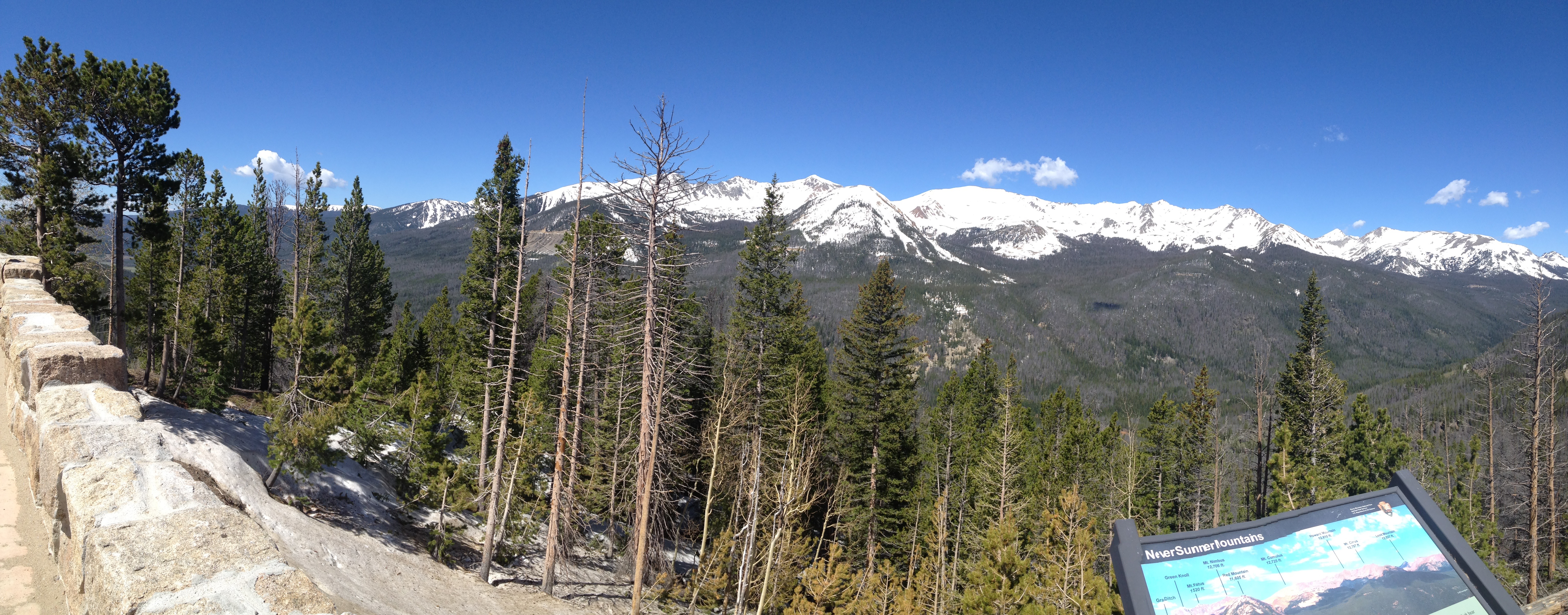
A panoramic view on Trail Ridge Road.
US-34, also known as Trail Ridge Road, takes us to dizzying heights. With a maximum elevation of 12,183 feet near Fall River Pass, Trail Ridge Road is the highest continuous paved road in the U.S. A continuous paved road is one that doesn’t simply doesn’t end at a summit, resulting in a turnaround to head back down. The road is considered continuous because it, um, continues.
For comparison purposes, the highest continuous paved road in the world is the Karakoram Highway, connecting China and Pakistan through the Khunjerab Pass in the Karakoram mountain range. The highway opened to the public in 1986; it reaches 15,397 feet in elevation. In recent years, the Karakoram Highway has become an adventure tourism destination, providing the pathway to expeditions for almost all peaks in Gilgit-Baltistan, including 28,251 foot K2, the Earth’s second highest mountain.
Because of its high elevation and extremely difficult construction, the Karakoram Highway is sometimes referred to as the Eighth Wonder of the World. The highway took 20 years to complete – and in the process, more than 800 Pakistanis and 200 Chinese workers lost their lives.
***
Let’s get back to the USA, in the state of Colorado, in Grand County, near the town of Grand Lake. That’s where we’re about to arrive at Rocky Mountain National Park’s western entrance.
On Trail Ridge Road.
From the Kawuneeche Visitor Center at the entrance to Rocky Mountain National Park, Trail Ridge Road follows the North Fork of the Colorado River through the Kawuneeche Valley.
Trail Ridge Road runs 48 miles from Grand Lake to Estes Park. The road crosses the Continental Divide at Milner Pass (10,758 feet). As you might guess, it is closed during the winter. Trail Ridge Road usually opens in late May.
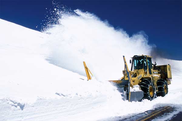
A snow plow operator clearing Trail Ridge Road in the spring.
National Park Service plow operators normally begin clearing the snow in mid-April, with crews from the west side of the park and crews from the east side of the park eventually meeting at the Alpine Visitor Center – 11,796 feet above sea level. That Visitor Center is the highest in the National Park System. It’s not easy being a snowplow operator on this road; snowdrifts often are up to 22 feet deep.
My Harley at 12,183 feet on Trail Ridge Road.
The road takes us through Rocky Mountain National Park. The park headquarters, Beaver Meadows Visitor Center, is a National Historic Landmark, designed by the Frank Lloyd Wright School of Architecture at Taliesin West in Scottsdale, Arizona.
We arrive in Estes Park at the eastern end of Rocky Mountain National Park. The town is named after Missouri native Joel Estes, who founded the community in 1859, then moved his family there four years later.
To learn more about Rocky Mountain National Park, click here.
***
From Estes Park, we head south on CO-7 for about 20 miles. To our right, we can see Longs Peak, at 14,255 feet, the highest peak in Rocky Mountain National Park.
We turn south on CO-72, also known as the Peak to Peak Scenic Highway. Established in 1918, it’s Colorado’s oldest Scenic Byway. Its curvy road winds through the Arapaho National Forest, and the Indian Peaks Wilderness Area.
As we ride south, we pass through Nederland, which began as a trading post between Ute Indians and European settlers during the 1850s. Nederland hosts several major events each year, including the NedFest, the historical Miners Day celebration, and the annual Frozen Dead Guy Days festival. Frozen Dead Guy Days commemorates an attempt by Norwegian immigrant Trygve Bauge to practice cryonics on Bredo Morstoel, his deceased grandfather. Uff da!
Frozen Dead Guy Days in Nederland.
From Nederland, it’s only a 15-mile drive east on Boulder Canyon Drive to Boulder, home of the University of Colorado. The last time I was in Boulder, in 1970, I had a burger, fries and a beer at a restaurant called The Sink. At the time, you could drink so-called 3.2 percent (by weight) beer in Colorado at age 18. The Sink is still there. President Obama dropped by in 2012, and noted foodie Anthony Bourdain checked it out in 2013. If you want to visit The Sink, click here.
***
Continuing south on CO-119 to Central City, we turn onto the Central City Parkway, which leads us to I-70. From here, it’s just a few miles on the Interstate to Idaho Springs, elevation 7,526.
Idaho Springs has several Hollywood connections. Scenes from the 2008 film, The Overbrook Brothers, were shot here. And, the 1970 film, Downhill Racer, portrayed an alpine ski racer from Idaho Springs, played by Robert Redford. A brief scene was shot on location here. Other Downhill Racer filming locations included Kitzbuhel, Austria; Wengen, Switzerland; Grenoble, France; and Boulder, Colorado. Click here to see the Downhill Racer trailer, including a much younger Redford, Gene Hackman and Camilla Sparv.
We don’t stay long in Idaho Springs. After just a few miles on I-70, we turn off onto CO-103, which takes us in the direction of one of Colorado’s 14ers – Mount Evans. The mountain is named after John Evans, second governor of the Colorado Territory from 1862 to 1865.
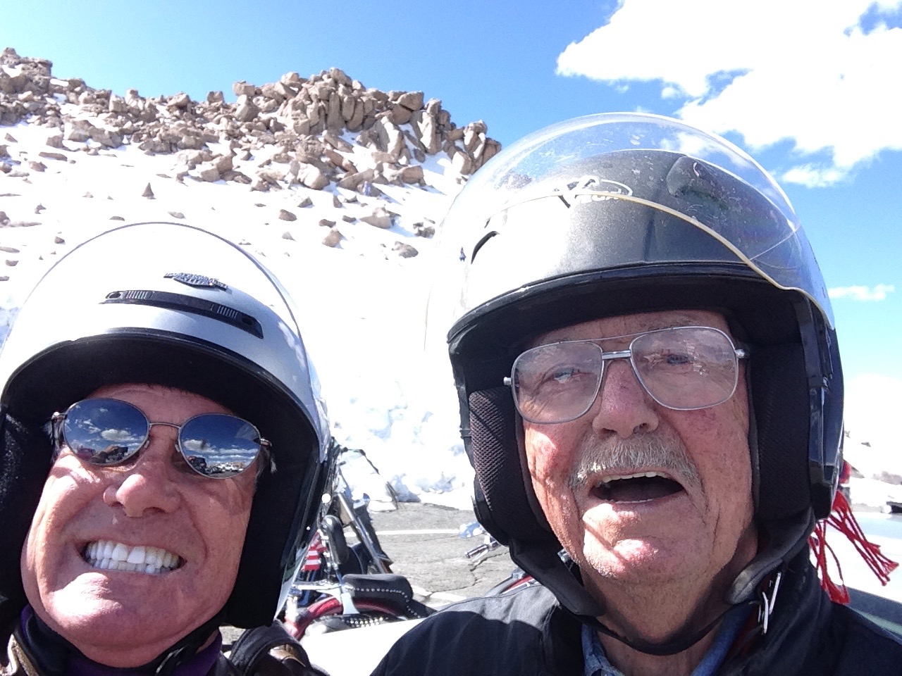
Smiling, but scared stiff.
Mount Evans rises to 14,265 feet, and dominates the Denver metropolitan area skyline, rising more than 9,000 feet above the Mile-High City. Mount Evans is 31 miles west of Denver, as the crow flies. Trip Advisor identifies 135 attractions in the Denver area, and ranks Mount Evans at the very top of the list. Perhaps we should take a closer look.
As we approach the Mount Evans welcome center, I’m secretly hoping it’ll start snowing, or blowing ferociously, or otherwise keeping me down here where it’s safe, comfortable and not the least bit threatening.
We arrive at the welcome center, and the Forest Service ranger discourages us from going up. Yessss! “I’ve been waving off bikers all day,” he tells us. “It’s been blowing 30-40 miles an hour and I don’t recommend riding up the mountain in those conditions.”
All of a sudden, the wind calms and my excuse goes away. The skies are blue, the road is dry, and I no longer have a reasonable excuse for NOT going up Mount Evans.
So we fire up the Harleys and roar up the mountain.
The road up Mount Evans. Buckle up!
Thirteen miles of climbing on CO-103 takes us past Echo Lake Park, where we turn onto CO-5 for another 14 miles, as we appear to be riding directly into the sky.
We are now on the Mount Evans Scenic Byway, riding toward the top of Mount Evans. Our Harleys climb this road to a final elevation of 14,130 feet – the highest paved road in North America! The road takes us within 135 vertical feet of the summit.
I am tense all the way to the summit, but feel a great sense of accomplishment and exhilaration once we reach the parking lot at 14,130 feet. Despite my misgivings, I’ll have to say the ride to the top was worth the stress. Who, among you, can say you’ve ridden to the top of Mount Evans?
Ray and I at the top of Mount Evans, the highest I’ve ever been without being on an airplane.
We’re almost half as high as the summit of 29,029 foot Mount Everest. OK, to be precise, we’re 48.675%25 as high. Still, it feels like we’re at the top of the world. It’s as high as you can get on a Harley, if you’re riding from La Quinta, California.
Interesting aside: while riding a Harley to the top of Mount Everest is out of the question, a 46-year-old New York man two years ago attempted to take his bicycle to the top of the world. It’s a pretty strange idea, even more silly than riding a Harley up Mount Evans. Click here to read Outside magazine’s story of the bicycle-up-Everest journey.
***
As you might expect, the Mount Evans Scenic Byway is strictly a summer time ride. The road generally opens around Memorial Day; the Colorado Department of Transportation closes the top five miles after Labor Day, and shuts down the rest of the road after the first “significant snowfall,” or the first weekend in October – whichever comes first.
You may recall that earlier today, we rode Trail Ridge Road, the highest continuous paved road in the U.S, and now we’re on the absolute highest paved road in North America. That’s a pretty awesome daily double! We are truly as high as you can get without riding on dirt or snow – or being on drugs.
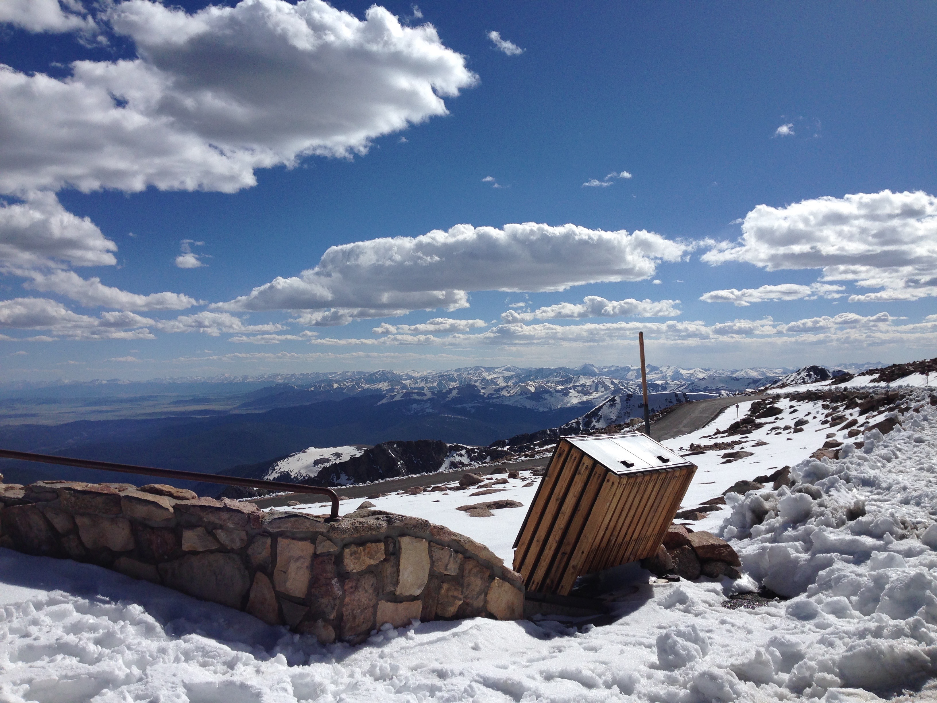
From Mount Evans, the view is breathtaking.
The view from Mount Evans.
And the air is thin. There’s considerably less oxygen up here than most of us are accustomed to. About 20 percent of people will experience symptoms of altitude sickness above 8,000 feet. We are considerably higher than that. There’s a big sign near the summit of Mount Evans, warning of the risks of altitude sickness.
Acute Mountain Sickness is the most common unhealthy response to altitude. It’s a collection of signs that your body is becoming ill and has not adapted successfully to a higher altitude. Symptoms include fatigue, dizziness, loss of appetite, nausea or vomiting, confusion, and difficulty walking. The single most important factor in reducing forms of altitude sickness is descending toward sea level.
On that note, we should consider returning to a lower elevation, which seems rather obvious, since there is no higher possible elevation.
Other than the stress of riding to the summit, I feel fine. No mountain ill effects at all.
If a mountain goat can climb Mount Evans, so can I. On a Harley.
Even though we feel fine, we’ve been on the road since early this morning and we’re ready to call it a day. We head back toward Idaho Springs, 6,600 feet below us. It’s a 27-mile ride down the mountain to Idaho Springs, a one-hour descent. From there, it’s 35 miles to Silverthorne, mostly on I-70.
***
Today was another loop day, but so much more than that. I now understand why Rocky Mountain National Park is Ray’s all-time favorite ride. It takes your breath away, in every possible way.
Day Eleven Summary: Historic US-40, on a rampage in Granby, getting high on a Harley, Robert Redford makes a cameo appearance.
Click here to view today’s route from Silverthorne to Rocky Mountain National Park, Mount Evans, and back.
Leaving Gunnison, we head west on US-50, riding along the Gunnison River and Blue Mesa Reservoir.
Turning onto Colorado Highway 92, an awesome road along the Gunnison River gorge.
At the western end of the reservoir, we turn onto CO-92, a twisty mountain road that winds along the Gunnison River gorge. It is probably the most spectacular road we’ve been on since beginning our ride through the Rockies.
Ray even says it might be one of his favorite rides of all time, which says a lot coming from someone who’s ridden more than 360,000 miles in the past 20 years.
The road has been designated a scenic byway, and is known as part of the West Elk Loop.
The West Elk Loop Scenic Byway is exactly that: scenic.
CO-92 takes us past Gould Reservoir and Crawford Reservoir, before we arrive in the town of Hotchkiss 52 miles later.
About 10 miles south of Hotchkiss is the tiny ranch town of Crawford, best known for its resident rocker, Joe Cocker. Cocker, who turned 70 a week ago, has owned his 240-acre ranch here since the 1990s. Called Mad Dog Ranch, it has a European-style, seven-bedroom, nine-bathroom house with a turret at the entrance. Like many his age, Joe and his wife, Pam, are downsizing. So the ranch is now for sale; it could be yours for $7 million.
One of Cocker’s biggest hits was “With a Little Help From My Friends,” a Lennon-McCartney song originally released on Sgt. Pepper’s Lonely Hearts Club Band in 1967. Click here to see Joe Cocker perform that classic song in concert a few years ago.
We pass by Mad Dog Ranch, named after Cocker’s 1970 album, Mad Dogs and Englishmen, then turn northeast onto CO-133 and head for Carbondale, Colorado. We’re now following the North Fork of the Gunnison River.
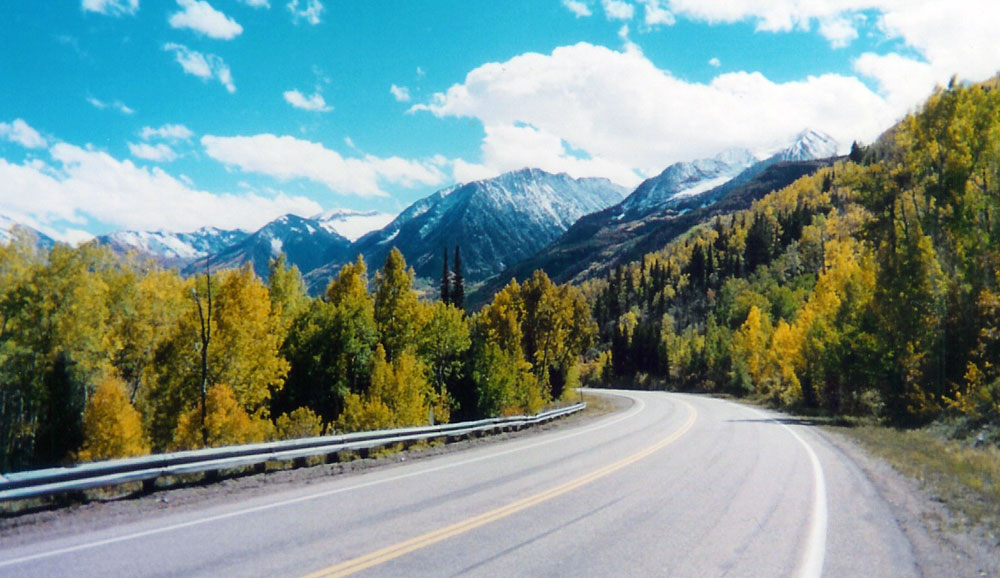
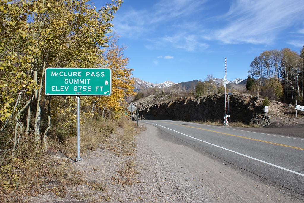
We pass the Paonia Reservoir and the town of Paonia, named for the flower, Paeonia mascula. The road begins to climb until we arrive at McClure Pass, which sits on the boundary between Pitkin and Gunnison Counties. The approaches on either side of the pass have an eight percent grade.
McClure Pass.
CO-133 takes us past the town of Redstone, home to the renowned Redstone Inn. Redstone was established in the 19th century as part of a coal mining enterprise by industrialist John Cleveland Osgood. Osgood built 84 cottages and a 40-room inn – for his coal miners. Most of these Craftsman-era Swiss-style cottages are still used as homes.
A dominant feature of Redstone is Redstone Castle, a 42-room Tudor-style mansion that Osgood built for his second wife, Swedish Countess Alma Regina Shelgrem.
***
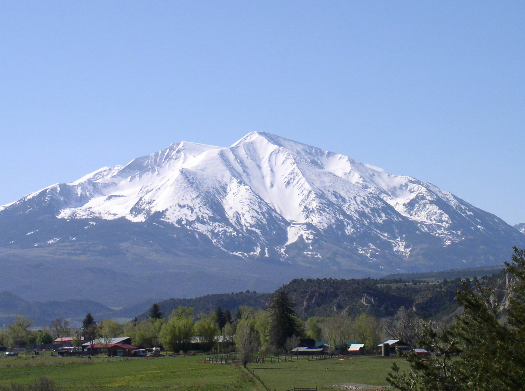
The Crystal River, a tributary of the Roaring Fork River, is on our right as we roll into Carbondale. Carbondale’s horizon is dominated by Mount Sopris, at the northwest end of the Elk Mountains, several miles south of town.
Mount Sopris is notable for having two summits, East Sopris and West Sopris. The summits are a half-mile apart, and have the identical elevation: 12,965 feet. The mountain is named for Richard Sopris, mayor of Denver from 1878 to 1881, and part of the first European expedition here in the Roaring Fork Valley.
Mount Sopris, 12,965 feet, dominates the skyline near Carbondale.
In Carbondale, we turn east on CO-82 and head for Aspen, elevation 7,945 feet.
When I grew up in Northern California, skiing at Squaw Valley, Alpine Meadows and Heavenly Meadows – in the Sierra Nevada Mountains near Lake Tahoe – I’d always dreamed about skiing in Colorado. Skiing Aspen was at the top of my list.
And yet, after 40 years of skiing – including Alta, where I taught at the Alf Engen Ski School; Sun Valley, where I skied while living in Boise; and five trips to France – I never carved a single turn at Aspen.
So it was somewhat ironic that last summer, I finally saw Aspen for the first time. Then, I arrived by car, with Sarah. Today, I roll in to Aspen on a Harley.
Last year, I rode a bicycle on the Rio Grande Trail from Carbondale to Basalt, about a 20-mile ride. Basalt has some great restaurants, terrific trout fishing in the Frying Pan River, and mountain biking in the Roaring Fork Valley.
Basalt is a charming mountain town halfway between Carbondale and Aspen.
Basalt is also home to some notable residents, including:
Wally Dallenbach Jr, NASCAR driver, who was born here.
Christy Smith, contestant on the CBS TV show, Survivor: The Amazon. She’s best known for being the first deaf contestant on the show.
Torin Yater-Wallace, freestyle skier and the youngest person ever to medal at the Winter X Games. Click here to watch Torin and friends skiing in Park City.
***
Today, I arrive in Basalt powered by 96 cubic inches of hot, throbbing metal, slightly more powerful than the rental bicycle I was on last year. From Basalt, we ride east on CO-82, past Snowmass, Woody Creek (home of the world-famous Wood Creek Tavern) and into Aspen.
About a mile past Buttermilk Mountain, we turn southwest on Maroon Creek Road to see what is believed to be the most photographed mountain scene in all of North America: the Maroon Bells. The Maroon Bells are two fourteeners, just 10 miles from Aspen, and a highly worthwhile side trip. Maroon Creek Road takes us to the Maroon-Snowmass Trailhead, at the foot of Maroon Lake. Once there, all you can say is Wow! My iPhone photos, while visually stunning, don’t do justice to the majesty of the view.
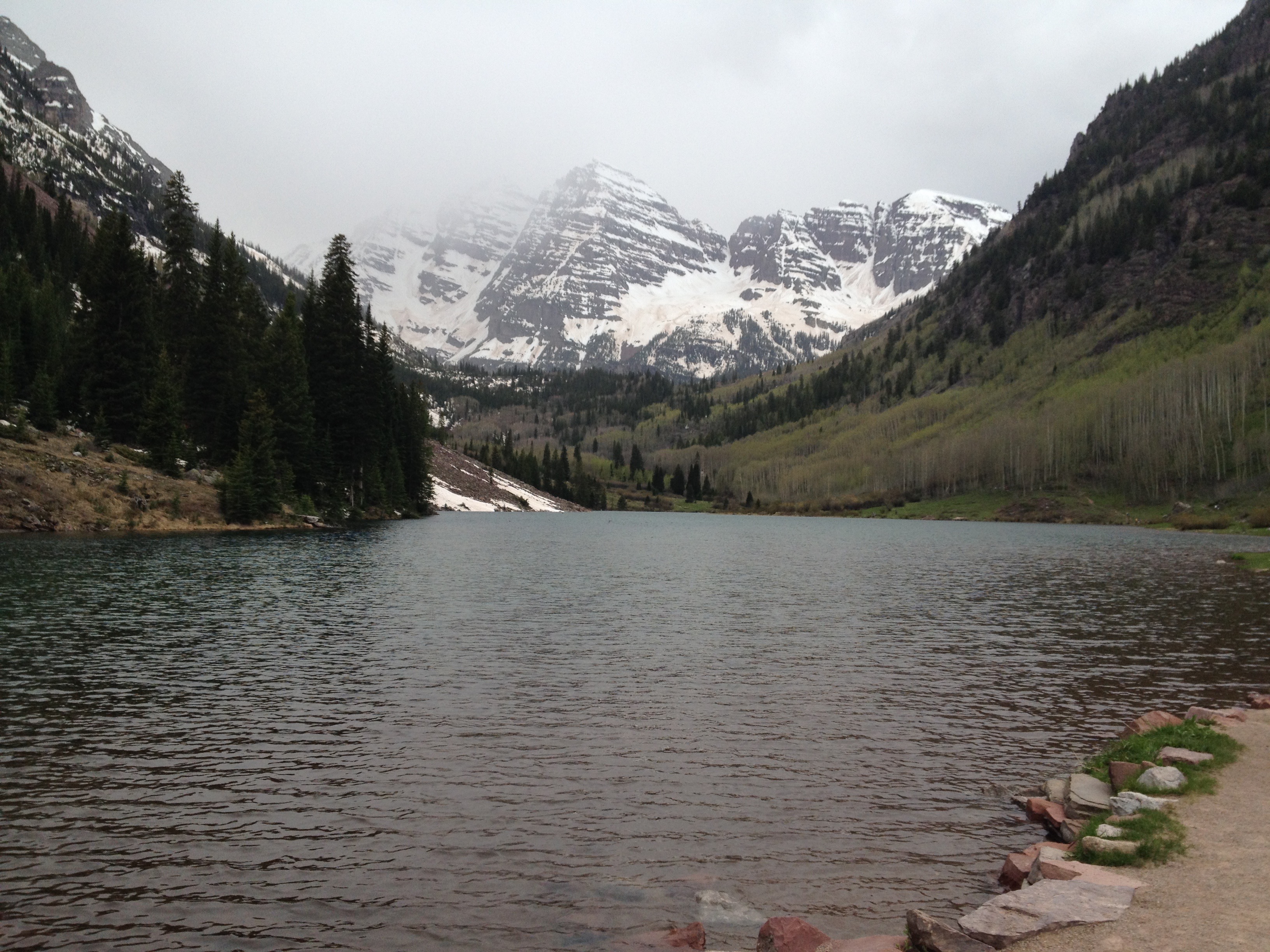
The Maroon Bells as I see them today, shrouded in clouds.
The Maroon Bells are two peaks – Maroon Peak and North Maroon Peak – separated by about a third of a mile. Maroon Peak is 14,156 feet and North Maroon Peak is 14,014 feet. The view of the Maroon Bells to the southwest is one of the most famous scenes in Colorado – which is saying a lot. Of Trip Advisor’s 59 rated attractions in the Aspen area, the Maroon Bells rank Number One; most of the visitor comments describe the view as just short of a religious experience. I’d have to agree.
Unfortunately, the skies are dark and clouds obscure the view of Maroon Bells as we arrive at the vista point. My photos today will not convey the beauty of this place, so I’ll include another one so you’ll know what we missed.
There are a multitude of hikes from the trailhead to the mountain itself. It’s a hugely popular summertime activity. But we have a lot more to see today, so that’ll have to wait for another visit.
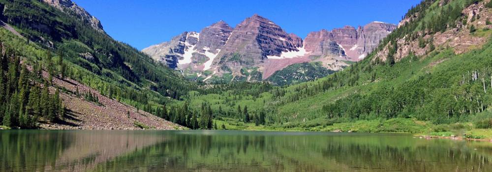
And, the Maroon Bells on a clear day. Not today.
So after gazing lovingly at the two mountains, we begin our descent down Maroon Creek Road back into Aspen.
***
The list of part-time Aspen residents reads like a who’s who of Hollywood: Jack Nicholson, Kevin Costner, Mariah Carey, Goldie Hawn and Kurt Russell, David and Victoria Beckham … and the list goes on. One thing’s clear: this skiing Mecca is a magnet for celebrities, who are drawn by the spectacular slopes and chic lifestyle.
Aspen’s sister cities include Chamonix, France; Davos, Switzerland; and Queenstown, New Zealand.
Aspen truly is a haven for the rich and famous. There’s a lot to see, a lot to do, a lot to buy, a lot to envy. Conspicuous consumption everywhere. But this is not a shopping trip, so we saddle up and head east on CO-82, toward Twin Lakes.
CO-82 is another scenic byway, appropriately named “Top of the Rockies.”
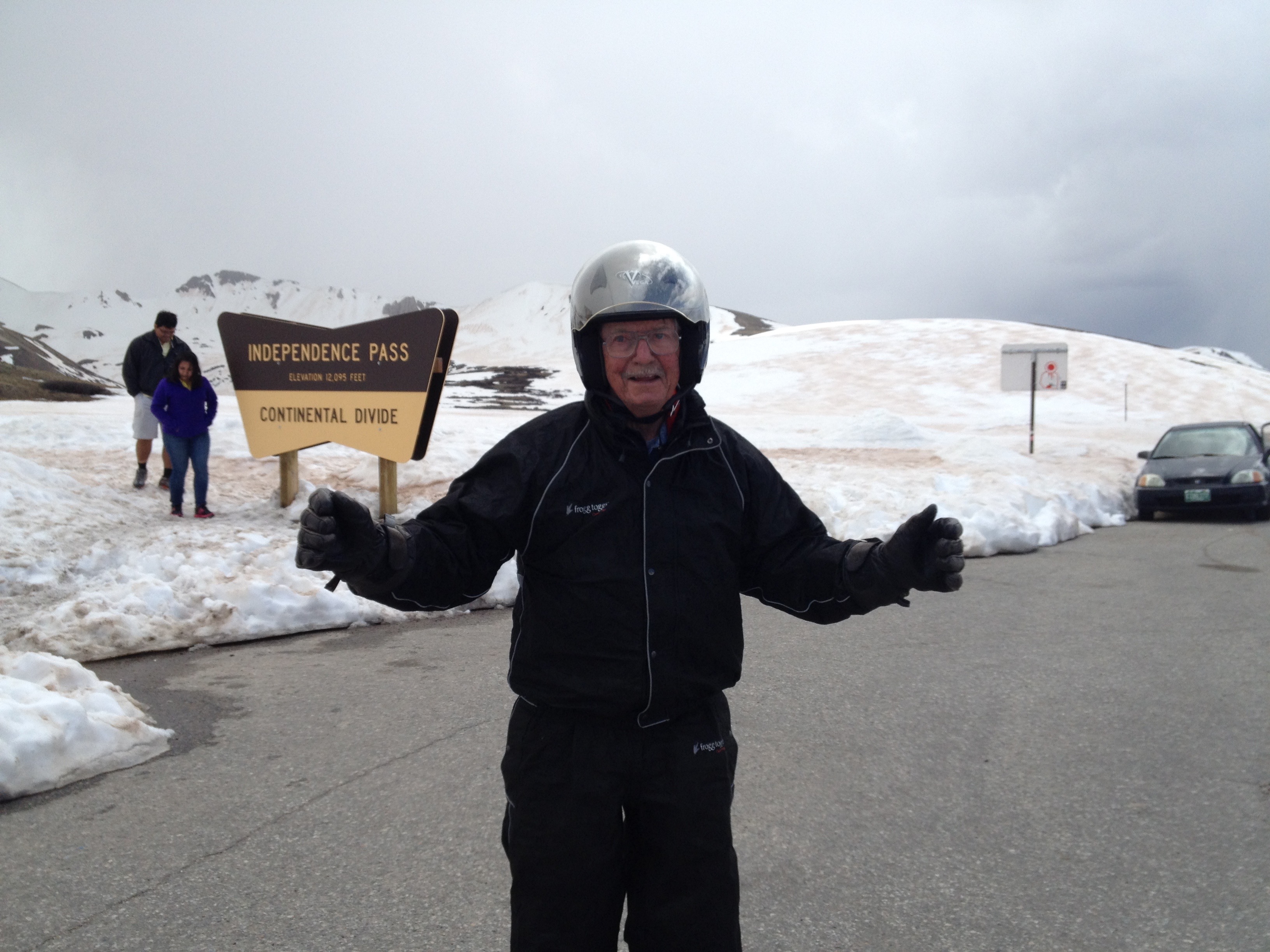
About 20 miles east of Aspen, we cross Independence Pass, the road climbing more than 4,000 vertical feet in those 20 miles.
At Independence Pass, crossing the Continental Divide.
At 12,095 feet, it’s the highest paved crossing of the Continental Divide. The road is closed in the winter, but when it reopens annually in late May, it’s a popular tourist destination. The road opened this year on May 22 — just last week.
Independence Pass gets its name from the village named Independence, which was established on July 4, 1879 – and is now a ghost town four miles west of the pass.
Since 2011, the pass has been on the route of the week-long USA Pro Cycling Challenge, held in late August. The bicycle race begins in Aspen and finishes in the streets of downtown Denver. Last year’s winner was American Tejay van Garderen, who rode 573 miles in 22 hours and 38 minutes. Previous winners include Levi Leipheimer and Christian Vande Velde. This year’s race kicks off August 18 in Aspen.
Climbing Independence Pass is challenging enough in a car, or a Harley, or any sort of motorized transportation. It seems well beyond crazy to ride over the pass on a bicycle.
At the top of the world, sort of.
At the pass, we stop at a scenic overlook, which on a clear day, offers views east to Mount Elbert, at 14,440 feet, Colorado’s highest peak. Mount Elbert is the second-highest mountain in the continental U.S. (California’s 14,505-foot Mt. Whitney, which Sarah Murr summited, is the highest).
At Independence Pass, it’s anything but clear and we have no idea where Mount Elbert is. We snap a few photos, and as it starts snowing lightly, we saddle up for the ride down the mountain.
To the west, more Fourteeners stand out – or they would on a clear day. Any other day, we’d be able to see the Maroon Bells, Snowmass Mountain and Capitol Peak. At some point, you become almost numb to these elevations. To put it in perspective, Mount Elbert is just shy of half as high as Mount Everest.
We leave Independence Pass, and begin our descent toward Twin Lakes. In 17 miles, we drop 3,000 feet, before arriving in Twin Lakes, elevation 9,200 feet. The arrival is low-key, to say the least, since there’s very little in Twin Lakes. It has a population of less than 200, and if you don’t eat at the Twin Lakes Inn, you’re not going to eat at all.
Just past Twin Lakes, we turn north on US-24 and 30 minutes later, arrive in the historic town of Leadville. At 10,152 feet, Leadville is the highest incorporated city in the U.S. It’s a former silver mining town, credited with producing 240 million troy ounces of silver and nearly 3 million troy ounces of gold. Fittingly, Leadville opened the National Mining Museum and Hall of Fame in 1987.
Stopping in historic Leadville.
The city annually hosts the Leadville Trail 100 Run, a 100-mile ultramarathon with elevations ranging between 9,200 and 12,620 feet. In most years, fewer than half the starters complete the race within the 30-hour time limit. The course record is 15 hours and 42 minutes, set by Matt Carpenter in 2005. Ann Trason holds the female record: 18 hours and 6 minutes.
Notable residents of Leadville have included:
Harvey Seeley Mudd, famous mining engineer and founder of Cyprus Mines Corporation. Harvey Mudd College is named in his memory. The College is part of the Claremont University consortium in Southern California; it includes Scripps, Pomona, Pitzer, Claremont KcKenna, and Harvey Mudd.
Barry Sadler, U.S. Army Green Beret and songwriter who made famous the song “Ballad of the Green Berets” in 1966. The song was one of the few in the 1960s to cast the military in a positive light.
Alice Ivers Tubbs, frontier gambler known as “Poker Alice.” A 1987 made-for-TV film about Poker Alice, starred Elizabeth Taylor in the title role.
***
After a short rest in Leadville, we turn north on CO-91, riding past Buckeye Peak, Chalk Mountain and Jacque Peak, which sits on the shoulder of the Copper Mountain Ski Resort.
As we near I-70, Copper Mountain is just to our west, and the Breckenridge Ski Resort is to our east.
We jump on I-70, and head north toward Dillon Reservoir, sometimes called Lake Dillon. The reservoir provides water for the city of Denver. It’s bordered by the towns of Frisco, Dillon and Silverthorne, where we’ll stay tonight.
The Dillon Reservoir provides water for the city of Denver.
Silverthorne served as a makeshift camp for workers during the construction of the Dillon Reservoir in the early 1960s. Silverthorne is known as the “gateway to Summit County. At 9,035 feet, it’s the highest lodging we’ll have on our trip.
***
Day Ten Summary: In the land of the rich and famous, contemplating an ultramarathon, in Aspen at long last, the Ballad of the Green Beret.
To view today’s route from Gunnison to Silverthorne, click here.
After a lifetime of being out of the loop, and often not even knowing where the loop is, today is loop day.
We are riding from Gunnison to Gunnison. Call it a Gunny Sack loop. Two hundred sixty-seven miles.
The loop begins by riding west on US-50 out of Gunnison for 10 miles, then turning south at the Blue Mesa Reservoir on CO-149, a twisty route through the San Juan Mountains.
Riding Colorado Highway 149, through the San Juan Mountains.
The San Juan Mountains are Colorado’s largest mountain range. Major towns, every one an old mining camp, include Creede, Lake City, Silverton, Ouray and Telluride – all of which we will visit on this trip. The highest point in the San Juan Mountains is Uncompahgre Peak, at 14,309 feet.
The San Juan Mountains have the distinction of having the highest U.S. airport with scheduled airline service – Telluride Airport, at an elevation of 9,070 feet. You can fly to Telluride on United, Frontier, or Great Lakes Airlines. Or, in your own Gulfstream V, aka G5, if that’s how you roll.
The San Juan and Uncompahgre National Forests cover a large portion of the San Juan Mountains.
***
Visiting old ghost towns in the San Juan Mountains is a popular tourist activity.
In search of ghost towns, we follow CO-149 for 86 miles, passing by Lake City, the Hinsdale County Museum and Lake San Cristobal, a high mountain lake that sits at 9,003 feet.
The road is spectacular, but it’s drizzling and much colder than we expected. So we stop in Lake City to warm up, dry out, and get something hot to drink.
Stopping at Mean Jeans for a hot chocolate on a cold day.
A local auto repair shop recommends Mean Jean’s, a cozy little place that is Lake City’s version of a Starbucks — but even better. Mean Jean’s offers free wi-fi, and makes me a mean cuppa hot chocolate. The barista adds whipped cream, and soon I’m warm again, ready to ride to our highest elevation on our trip so far.
Lake San Cristobal is the second largest natural lake in Colorado. San Cristobal means Saint Christopher, in Spanish. Saint Christopher is a patron saint of travelers. We need all the help we can get. We dressed for 60-degree weather, and it’s in the low 40s. Brrrrr!
From Lake City, the road climbs quickly and steeply. In 10 miles, we ride over Slumgallion Pass — at 11,530 feet, a new high for our ride. The north side of Slumgallion Pass has the steepest grade (9%) of any continuously paved road in Colorado.
The weather clears — a little — and soon we cross the Continental Divide at 10,901-foot Spring Creek Pass.
Near the Rio Grande River, we turn north, staying on CO-149. The Rio Grande flows from southwestern Colorado to the Gulf of Mexico, along the way forming part of the Mexico-U.S. border.
There is no night in Creede.
We follow the Rio Grande on CO-149, passing through Creede, a historic old mining town in appropriately named Mineral County. Creede’s motto: “There is no night in Creede!”
Creede, elevation 8,800 feet, has been featured in a number of Hollywood films, including:
The Shootist in 1976 with John Wayne, about a dying gunfighter who spends his last days looking for a way to die with the least pain and the most dignity.
The final scene in the 2007 drama, The Assassination of Jesse James by the Coward Robert Ford, takes place in a saloon in Creede, where outlaw Robert Ford (played by Casey Affleck) is gunned down by Edward O’Kelley. The scene was shot on a set in Edmonton, Alberta, that recreated much of 19th century Creede. Earlier in the film, Ford had killed Jesse James, played by Brad Pitt.
Scenes from the 2013 western, Lone Ranger, starring Armie Hammer and Johnny Depp, were filmed in and around Creede.
We snap a few photos in Creede, then continue our ride along the Rio Grande. In the town of South Fork, we turn east on US-160. Here in South Fork, the Griswold family spends the night at a campground as part of the 1983 Harold Ramis movie, National Lampoon’s Vacation. The movie starred Chevy Chase as Clark Griswold, and is considered to be one of the 50 greatest comedy films of all time. Number one on many lists: Airplane (“What’s your vector, Victor?”).
After 15 miles on US-160, we roll into Del Norte, named after the river Rio Grande del Norte – “Grand River of the North.” Del Norte, elevation 7,884, is a good place to stop for gas, and a snack at the Three Barrel Brewing Company.
It’s a sleepy little town, home to Patriot Bible University, an independent Baptist correspondence school. The unaccredited school issues religious degrees only, and has been criticized as a “degree mill,” with low graduation requirements and high graduation rates. You can prepay for a degree ($1,899) and walk away with a Doctor of Ministry in a matter of months.
In Del Norte, we skip Bible study, instead gassing up and stopping at Boogie’s Restaurant. Ray has his usual hamburger, and calls this one the best burger he’s has in a long while. For desert, Ray has cherry pie, which he devours.
Ray has the “best burger in ages” at Boogies.
Boogies, like much of Colorado culture, has Denver Broncos paraphernalia throughout the restaurant. The Broncos may have sucked in this year’s Super Bowl, but they rock the house at Boogies.
We turn north on US-285, not far from Monte Vista. With 4,500 residents, it’s the most populous city in Rio Grande County. Unusual for a Rocky Mountain ride, the road is a straight line for 25 miles. No turns, not even a bend in the road.
At the junction of CO-114, we veer west for 62 miles, and enjoy some mountain curves for a change. In the distance, we see Razor Creek Dome (11,530 feet) and Sawtooth Mountain (12,304 feet).
Well, we would see them if the skies hadn’t dramatically darkened and dropped buckets of rain on us for much of the ride back to Gunnison. It is cold, windy, wet and not as much fun as it should be. Good thing we thought to bring our rain suits — and wear them.
At US-50, we turn west and ride the remaining eight miles to Gunnison, which completes our loop.
Gunnison, when it’s not cold and rainy.
We arrive cold and wet — and very glad to be parking the bikes for the night.
***
Day Nine Summary: Living the high life, flying your G5, looking for ghost towns, no night in Creede.
To view today’s route from Gunnison to Gunnison, click here.
Sipping my morning coffee in Palisade, I wish Eldon a happy birthday. Today, he’s a very young 69.
Other notable May 29 birthdays include John F. Kennedy, 35th President of the U.S., who would be 97 years old today; comedian Bob Hope, long-time host of the PGA Tour event in the Palm Springs area bearing his name; singer LaToya Jackson, Michael’s older sister, who is 58 today; and basketball player Carmelo Anthony, who led the NBA in scoring last year, and turns 29 today.
Happy Birthday to all, but especially Eldon.
Happy Birthday. It’s a wrap!
Kathryn presented Eldon with several gifts from REI, which he unwrapped like a child at Christmas. One gift was a hit, the other a miss. Both were presents that went well with an outdoor, active lifestyle — which describes much of the Grand Junction area demographics.
We leave Palisade, so Eldon and Kathryn can celebrate quietly … or as loudly as they want. They’ll just have to party without us, because we’re riding the Rockies today.
Our bikes take us south from Palisade, through Whitewater, on our way to Nucla. We skirt the Dominguez-Escalante National Conservation Area, which has canyons along the Uncompahgre Plateau, along the Gunnison River.
We are on CO-141 for about 90 miles of mountain roads before passing by Nucla. The town’s name comes from its founders’ intent that it serve as a “nucleus” for the surrounding farms and mines. In the early 20th century, uranium mining was big here in Montrose County.
Colorado Highway 141, along the Dolores River gorge.
Colorado is considered to have the third largest uranium reserves of any US state, behind Wyoming and New Mexico. There are apparently no Colorado mines currently producing uranium, a testament to fluctuating mineral prices. That’s a radical departure from the uranium boom that began in the late 1940s.
Nucla became a key supplier of nuclear fuel during the Cold War era. While many places shudder at such a prospect, Nucla would like to see uranium mining and milling come back.
But Nucla may be best known as Colorado’s first and only town mandating gun ownership. I am not kidding.
A Nucla municipal ordinance requiring heads of households to own guns and ammunition was enacted in May 2013. The rationale, according to the Nucla Town Board: to provide for and protect the safety, security and general welfare of the town and its inhabitants.
Nucla Town Board member Richard Craig cleans a shotgun in his home. The town of Nucla has some wacky gun laws.
When Ray rides, he’s packing heat for his and my safety – so I’m pretty sure we’re in compliance with the Nucla way of life.
The most notable resident of Nucla seems to be Bill Symons, a Canadian Football Hall of Famer, who was born here. He was a running back with the Toronto Argonauts, a long way from Nucla.
***
From Nucla, we ride east on CO-145 and then on CO-62, around the Uncompahgre National Forest. At Ridgway, we turn north on US-550.
Ridgway was featured in the John Wayne movie, True Grit, and other western movies including How the West Was Won, and Tribute to a Bad Man. Ridgway has the only stoplight in Ouray County – at the intersection of US-550 and CO-62.
A little-known fun fact about Ridgway: the Grammy Award trophy is manufactured here exclusively by Billings Artworks. The trophies are all hand-made, assembled and plated on site.
Grammy awards put Ridgeway, Colorado, on the map.
The Gramophone trophy – Grammy for short – has been awarded nearly 8,000 times since the first Grammy Awards ceremony in 1959. Hungarian-British conductor Sir Georg Solti has won the most Grammys: 31. Most Grammys won by a female: 27, by Allison Krauss, bluegrass and country singer/songwriter.
There have been as many as 109 categories, some of them quite specialized. One Grammy category, Best Disco Recording, was awarded only once, in 1980. The winner was Gloria Gaynor, for “I Will Survive.”
Other nominees for the disco Grammy that year included “Boogie Wonderland,” “Don’t Stop ’til You Get Enough,” Da Ya Think I’m Sexy?” and “Bad Girls.” Because of a subsequent disco backlash, the category was discontinued after only one year. How can you not love disco? Click here to remind yourself why polyester leisure suits were the bomb.
***
Notable residents of the Ridgway area include:
Charles Ergen, co-founder and CEO of EchoStar Communications, the parent company of Dish Network. His net worth is estimated at more than $12 billion.
Ralph Lauren, fashion designer, who has a 17,000-acre ranch near here. He was born Ralph Lifshitz, but who would wear clothes with that label?
Dennis Weaver, Emmy Award-winning actor, best known for his work as Chester Goode on the TV show Gunsmoke.
Danny Thompson, race car driver, businessman and son of the legendary racer Mickey Thompson. Danny owns a fabrication company and race shop in the area. Click here to watch him drive a 1,300-horsepower Mustang 265 miles an hour on the Bonneville Salt Flats.
***
From Ridgway, we continue north on US-550 to Montrose. The city was incorporated in 1882, and named after Sir Walter Scott’s novel, A Legend of Montrose.
Montrose sits at 5,806 feet above sea level, and is considered a gateway to many spectacular areas in the Rockies. If you have time in Montrose, you can visit the Museum of the Mountain West, the Ute Indian Museum, or the Russell Stover Candy Factory.
You can also head east out of town and visit a nearby National Park, the Black Canyon of the Gunnison. That’s our plan.
At Black Canyon of the Gunnison National Park.
The Black Canyon of the Gunnison National Park is only about 11 miles northeast of Montrose. East on US-50 for 6 miles, North on CO-347 for 5 miles, and we arrive at the Park’s visitor center.
The Gunnison River drops an average of 34 feet per mile through the entire canyon, making it the fifth-steepest mountain descent in North America. By comparison, the Colorado River in the Grand Canyon drops an average of 7.5 feet per mile.
The Black Canyon is so named due to its steepness, which makes it difficult for sunlight to penetrate the canyon. As a result, it’s often shrouded in shadow, causing the rocky walls to appear black. At its narrowest point, the canyon is only 40 feet wide at the river. The canyon is known for crumblng rock and dizzying heights. It’s a haven for rock climbers. Experts only.
Rock climbing the Black Canyon of the Gunnison. Don’t try this at home.
For more on the Black Canyon of the Gunnison, click here.
***
After staring at the canyon walls, we press on, riding south on CO-347, then east on US-50 toward Gunnison.
The ride along the Gunnison River is a keeper, or at least it would have been if it hadn’t rained on us for most of the 65 miles to Gunnison. The skies were black, the roads slick, and the temperatures plunging.
Fortunately, we saw the rain coming, and put on our rain gear before leaving the park. We may have been cold, but we weren’t wet!
We pass the Blue Mesa Reservoir, the largest body of water entirely in Colorado. With 96 miles of shoreline, it’s the largest lake trout and kokanee salmon fishery in the U.S. It was the first large dam built along the Gunnison River.
We follow the Gunnison River, at first on the south side of the River, then crossing to the north side at Lake Fork Arm. We continue along the river’s edge to Gunnison, which sits at 7,700 feet.
Gunnison was named in honor of John Gunnison, a U.S. Army officer who surveyed for the transcontinental railroad in 1853. The city is home to Western State Colorado University, originally founded as the Colorado State Normal School for Children in 1901. A normal school is one created to train high school graduates to be teachers; its purpose is to establish teaching standards, or norms – thus the word “normal.”
Having a cold one before dinner in Gunnison, Colorado.
***
Day Eight Summary: Happy Birthday Eldon, a one-stoplight county, disco fever in Grammy-town, a school for (somewhat) normal children.
Click here to view today’s route from Palisade to Gunnison.
We say goodbye to Moab, and ride northeast on UT-128, along the Colorado River.
The entire length of this highway has been designated the Upper Colorado River Scenic Byway, part of the Utah Scenic Byways program. Residents of Moab often refer to UT-128 as the “river road.”
It’s a spectacular river canyon, pretty much made for a Harley. The road follows the southern bank of the Colorado River. The sheer sandstone walls of the gorge along UT-128 are recommended on vacation guides around the world.
The Colorado River gorge along Utah Highway 128.
The gorge widens where the highway passes by Castle Valley and Professor Valley, where many western films have been shot, including Rio Grande.
Today, the river is a muddy shade of brown, typical of when the river is runny freely.
After about 40 miles, we turn onto US-6, which takes us to I-70. This stretch of road is known as the Grand Army of the Republic Highway, honoring a Civil War veterans association.
We continue on I-70 East for about 35 miles, not exactly my favorite thing to do. I find Interstate riding to be boring, not nearly as exciting as riding a river gorge or mountain road. But sometimes, it’s the only way to get where you’re going, so I suck it up and we roll into Colorado.
***
On Aug. 1, 1876, President Ulysses S. Grant signed a proclamation admitting Colorado to the Union as the 38th state. The name Colorado has a Spanish origin. It refers to red, as in the color of the reddish soil of the plateaus.
Colorado has a reputation for being a state of active and athletic people, reportedly with the lowest obesity rate in the nation. People here are both healthy and happy: Colorado is one of two states to legalize both the medicinal (2000) and recreational (2014) use of marijuana.
A welcoming sign. Nice and subtle.
As we cross the border into Colorado, we see little immediate evidence of its legal marijuana use. No billboards announcing weed for sale, no roadside bake sales, no vending machines. Vending machines? Yep. In the posh resorts of Vail Valley, the nation’s first marijuana vending machines are open for business. Last month, a vending machine spit out its first products, including edibles and pre-rolled joints. The machines are called Zazzz. Great name.
At Fruita, we turn off the Interstate to visit the Western Colorado Dinosaur Museum. We’re in the heart of dinosaur country. We see real bones from dinosaurs such as the Apatosaurus and Allosaurus. There are full-size cast skeletal mounts of the Velociraptor (made famous in the movie Jurrasic Park), Stegosaurus and Mymoorapelta, among others. Click here to see the memorable velociraptor kitchen scene from Jurrasic Park.
Sheer terror with the “Super Slasher” at the Western Colorado Dinosaur Museum.
Leaving the museum, we head south on CO-340 and then Rimrock Drive for a short ride to the Colorado National Monument Visitors Center.
To learn more about Colorado National Monument, click here.
The Colorado National Monument’s feature attraction is Monument Canyon, which we ride on our way to Palisade, Colorado, just east of Grand Junction. Monument Canyon includes rock formations such as Independence Monument, Coke Ovens and the Kissing Couple.
Spectacular views at the Colorado National Monument.
The Kissing Couple is a 400-foot-high needle of sandstone that has a vertical split near the top, separating it into two seemingly intertwined columns, like two giant lovers locked in a timeless embrace. The Kissing Couple, first ascended in 1960, is quite popular among rock climbers.
We’re on Monument Road for about 15 miles, and it is quite spectacular.
The canyon is every bit as awesome as any we’ve seen on this trip. There’s currently a raging debate, locally and in Washington DC, over whether to turn Colorado National Monument into a National Park.
My opinion — and I don’t get a vote — it ought to be a National Park.
More rugged beauty at the Colorado National Monument.
As we leave Colorado National Monument, the road takes us to Grand Junction, whose notable residents include:
Owen Aspinall, former Governor of American Samoa, who was born here. Along with traditionally garbed island chiefs, Aspinall was one of the first to greet and congratulate the crew of Apollo 10 after their return to Earth.
Dalton Trumbo, Academy Award-winning screenwriter (Exodus, Spartacus, Thirty Seconds Over Tokyo). There’s a fountain on Main Street honoring him.
Richard Wank, former TWA pilot, until the airline rudely declared bankruptcy on his 60th birthday, and was taken over by American Airlines. Capt. Wank grew up in Grand Junction, and is my first cousin, once removed. There are no known statues or fountains honoring him.
We slog through Grand Junction, riding in the vicinity of 1345 Chipeta Ave., where Capt. Wank grew up, long before he ever entertained fantasies of flying. Chipeta, or White Singing Bird, was a Native American woman and the second wife of Chief Ouray of the Uncompahgre Ute Tribe. You’ll hear more about Ouray and Uncompahgre over the next few days as we ride the Rockies.
One more note about Grand Junction: the biggest party in town all year long is going on right now. It’s the week-long Junior College Baseball Tournament, the national juco championship. Ten teams began play on May 24, and the title game is this Saturday at 7 pm.
The games are played at Suplizio Field, near Colorado Mesa University (CMU), which plays it’s games there, along with the minor league Grand Junction Rockies, a farm team of Major League Baseball’s Colorado Rockies. My pick in Saturday’s title game: Miami Dade.
***
Meeting old friends, the McBrides, in Palisade.
Eventually, I end up among the fruit orchards of nearby Palisade, elevation 4,728 feet. My old friend from Boeing in Seattle, Eldon McBride, lives here with his wife Kathryn. I’ll be staying with Eldon and Kathryn tonight at their home not far from the Colorado River.
Palisade lives in the shadow of Grand Junction, but has its own vino vibe. It’s known for peaches and vineyards. Among the best uses of grapes here: Canyon Wind Cellars, De Beque Canyon Winery, Varaison Vineyards and Winery, and Talon Winery. There’s even a winery named after Eldon’s wife: St. Kathryn Cellars.
After some R and R at the McBride home, the original plan was to head for the Grand Mesa, known as the world’s largest flat-topped mountain. A mesa is an elevated area of land with a flat top and sides that are usually seep cliffs. Mesa is Spanish for table; mesas get their name from their characteristic table-top shape.
The Grand Mesa is about 500 square miles, and reaches a maximum elevation of 11,333 feet at Crater Peak. The top of the Grand Mesa is a layer of basalt poured by lava about 10 million years ago.
We ride CO-65 to and through the Grand Mesa. It’s also known as the Grand Mesa Scenic and Historic Byway. The road climbs to more than 10,000 feet, and passes by the Powderhorn Ski Resort.
Just past Powderhorn are dozens of small mountain lakes that offer trout fishing, hiking, canoeing and other mountain experiences.
The Grand Mesa is said to be the world’s largest mesa.
All that beauty on the Grand Mesa will have to wait for another day, though. It’s too much fun catching up with Kathryn and Eldon, so we decide to skip the a Grand Mesa, and instead have a drink and a home-cooked meal.
***
Since Riding the Rockies With Gary is the name of this blog, I should take a moment to share some Rocky Mountain basics.
The Rockies stretch more than 3,000 miles from the northernmost part of British Columbia, in western Canada, to New Mexico. On this trip, we plan to go as far north as Rocky Mountain National Park, in Colorado.
We’ll become familiar with the Continental Divide, a natural boundary line separating the watersheds of the Pacific Ocean from those of the Atlantic Ocean. Technically, a continental divide is a drainage divide on a continent where the drainage basin on one side of the divide feeds into one ocean or sea, and the basin on the other side feeds into a different ocean or sea.
Standing atop Long’s Peak, one of the 14ers in Colorado.
The Continental Divide runs north-south from Alaska to Northwestern South America. In the continental U.S., it follows the crest of the Rocky Mountains.
The Rocky Mountains were initially formed as many as 80 million years ago, when a number of geological plates began to slide underneath the North American plate. Since then, further tectonic activity and glacial erosion have sculpted the Rockies into dramatic peaks and valleys.
The northern Rockies were once explored by Lewis and Clark, around 1805. Now it’s time for Ray and Gary, circa 2014.
***
A number of popular songs have been inspired by the Rocky Mountains, among them “Rocky Mountain High” (recorded by John Denver in 1972) and “Rocky Mountain Way” (recorded by Joe Walsh in 1973).
Rocky Mountain High, written after Denver’s move to Aspen, is one of Colorado’s two official state songs; the other is “Where the Columbines Grow.”
Joe Walsh and Brad Paisley performing “Rocky Mountain Way.”
“Rocky Mountain Way” is not among Colorado’s official state songs, but it may be one of the most commonly performed tunes whenever Joe Walsh picks up a guitar in front of a crowd. It’s Number 57 on Ultimate Classic Rock’s list of Classic Rock Songs.
Click here if you want to see Joe Walsh perform his signature song with Brad Paisley on CMT.
The Rockies have the highest peaks in mainland North America. The biggest one is Colorado’s Mount Elbert, at 14,440 feet. Colorado has more than 50 mountain summits that are 14,000 feet or higher. They’re known as the 14ers.
Our first National Park of the day is Capitol Reef, which we enter just eight miles east of our Torrey motel.
Capitol Reef National Park was established in 1971. It has 241,904 acres of colorful canyons, ridges, cliffs, towers, arches, buttes and monoliths. The area is named for a line of white domes and cliffs of Navajo Sandstone, each of which looks a bit like the U.S. Capitol building. The local word “reef” refers to any rocky barrier to travel.
Capitol Reef is a beautiful landscape of multi-hued rock layers. You see geologic formations of the Waterpocket Fold and Cathedral Valley, archeological evidence of the ancient Fremont culture, vestiges of a historic Mormon settlement, and a range of habitats for plants and animals.
Chimney Rock, near the entrance to Capitol Reef National Park.
Because UT-24 is the main east-west road through the park, there’s no toll to ride through much of Capitol Reef – unless you’re traveling on Scenic Drive south of the Fruita Campground. We are just passing through.
We barely notice Fruita, the best-known settlement in Capitol Reef. Fruita, at the confluence of the Fremont River and Sulphur Creek, was established in 1880 under the name Junction. It became known as Fruita around 1902, in large part because of its productive fruit orchards. (In a few days, we’ll visit Fruita, Colorado, too.)
The town was abandoned in 1955 when the National Park Service purchased Fruita to be included in Capitol Reef National Park. Today, few buildings remain, except for a restored one-room schoolhouse. The orchards are still here, now under the ownership of the National Park Service, and have about 3,100 trees – including cherry, apricot, peach, pear, apple, plum, mulberry, almond and walnut. Visitors to the park are welcome to stroll in any unlocked orchard and consume ripe fruit.
Click here to learn more about Capitol Reef National Park:
***
We stay on UT-24 for 92 miles, following the Fremont River as it winds from Torrey toward Hanksville.
No vacancy at the Hanksville Inn.
Hanksville, elevation 4,295 feet, is just south of the confluence of the Fremont River and Muddy Creek. Together, they form the Dirty Devil River, which then flows southeast to the Colorado River. There’s little in Hanksville today, except a few service stations and the Hanksville Inn — which has a “No Vacancy” sign in use.
Hanksville got its name in 1985, named after Ebenezer Hanks, leader of a group of Mormon pioneers who established a small settlement here. It may be best known as a supply post for Butch Cassidy and the Wild Bunch, who would hide out at Robbers Roost in the desert southeast of town. Butch and his bunch were popularized by the 1969 movie, Butch Cassidy and the Sundance Kid, starring Robert Redford, Paul Newman and Katharine Ross. Click here to see the trailer for one of the American West’s original buddy films.
We have no reason to hide from the law, so we continue on UT-24, past Goblin Valley State Park, which has thousands of hoodoos and hoodoo rocks. Hoodoo rocks! Or, grammatically speaking, should I say, hoodoos rock?
***
We continue on UT-24, with barely a curve in the road, until after an hour or so, it meets up with I-70. We jump on the Interstate for 33 miles, crossing the Green River, as well as its namesake city, Green River. The Green River is a tributary of the Colorado River.
And, as a musical aside – “Green River” is yet another John Fogerty song, originally released in 1969. Fogerty’s Green River was in California, and its real name was Putah Creek. Need another musical interlude? Click here to visit the Green River.
***
At the intersection of US-191, we turn south and ride the 31 remaining miles to Moab, Utah.
Canyonlands National Park. Beautiful, and we’ll save it for another day.
En route to Moab, we pass the turnoff to Canyonlands National Park, one of the few National Parks in the Mountain West we skip on this trip. As we near Moab, we also pass by the entrance to Arches National Park.
Moab is a Biblical name, referring to an area of land located on the eastern side of the Jordan River.
There are two schools of thought about how the city of Moab got its name. In one, historians think the city in Utah came to use the name because the postmaster believed that the biblical Moab and this part of Utah were both “the far country.” Others believe the name has Paiute origins, referring to the word “moapa,” meaning mosquito.
Either way, Moab is known for its outdoor recreation opportunities, including four-wheeling, whitewater rafting and kayaking on the Colorado River, canoeing on the Green River, mountain biking, rock climbing, BASE jumping and slacklining. If you can’t find something to do in Moab, you’re not trying very hard.
At 4,026 feet elevation, Moab is considered high desert. It has an arid climate, characterized by hot summers and cool winters.
Even if you haven’t been to Moab, you’ve probably seen it on TV, and in the movies. Here are some of the movies that were shot in or near Moab: Stagecoach, Indiana Jones and the Last Crusade, Thelma and Louise, City Slickers II, and Riders of the Purple Sage.
Corona Arch, home to the world’s largest rope swing.
The world’s largest rope swing isn’t far from here, at the 105-foot Corona Arch. You gotta check it out, as about 23 million other YouTubers have. Click here to take a swing on Corona Arch.
Don’t try this at home.
It’s called “pendulum swinging,” and it can be quite dangerous. A 22-year-old Utah man died last year trying the rope swing, when he miscalculated the length of his rope. He made the rope too long, and when he jumped off Corona Arch, he ended up diving into the ground. Fatal face plant. Ouch.
***
Danger isn’t my thing.
As you may recall from previous blogs, I ride like Grandma, which explains, in part, why I’ve had 40 years of riding experience and tens of thousands of miles – with no mis-haps.
Five miles before Moab, we arrive at the Park entrance. Arches is home to Delicate Arch, the most recognized and photographed Arch in the park – and the artwork for Utah automobile license plates. Delicate Arch, formed of Entrada Sandstone, is a symbol for Utah.
The Visitor’s Center at Arches National Park has a fantastic view.
Noted writer Edward Abbey was a park ranger at Arches National Monument, where he kept journals that became his book, Desert Solitaire. He said of Delicate Arch’s significance: “It lies in the power of the odd and unexpected to startle the senses and surprise the mind out of their ruts of habit, to compel us into a reawakened awareness of the wonderful – that which is full of wonder.”
Arches has the largest concentration of natural stone arches in the world — more than 2,000. To qualify as an official stone arch, a hole must have an opening at least three feet long in any one direction. There is no requirement for width, though. Quite a few of the arches in the park are so skinny you have to look carefully to see any light through them.
The park has arches, windows, bridges, hoodoos, spires and towers, all descriptive names given to sandstone features visible in the park.
Balanced Rock is one of the more photographed formations in Arches National Park.
Among Arches’ many well-known rock features are Balanced Rock, Courthouse Towers, Double Arch, Landscape Arch and Wall Arch, and Skyline Arch. There are viewpoints to see many of these Arches. Ray and I check out as many as time allows.
The park was created as a National Monument in 1929, then re-designated as a National Park in 1971.
Click here to learn more about Arches National Park.
My Harley is dwarfed by the towering sandstone rock formations in Arches National Park.
***
A quick aside about my writing/typing: several of you eagle-eyed blog readers have pointed out an occasional typo or non-sensical word, phrase or sentence construction.
OK, I’ll fess up. Pounding out blog posts and photo captions at the end of a long day is more fraught with error possibilities than I expected.
The ever-vigilant Eldon McBride noticed yesterday’s big boo-boo: “quacking aspens.” What I meant was “quaking aspens.” Who knew?
Apple’s autocorrect function sometimes has a way of out-thinking users like me. Aargh!
So apologies, in advance, for other egregious typographical errors that may pop up over the next 12 days. As some of you pride yourselves in finding these mistakes and notifying me of them, please don’t be shy about correcting me. As Hemingway (or some literary person) said, “every writer needs an editor.”
***
Day Six Summary: Riding in the shadow of Ebenezer Hanks, rope-swinging Corona Arch, Hollywood comes to Moab, rocking out in Arches National Park.
Click here to view today’s route from Torrey to Moab.
It’s Memorial Day, a Federal holiday observed every year on the final Monday of May. Most of you have the day off, either because you don’t work, don’t feel like working, or like me, are simply unemployable.
Memorial Day honors all Americans who have died while serving in the military. More than 1,321,000 U.S. servicemen and women have given their lives so that we all can be free, or at least ride Harleys through the Mountain West.
Many Americans visit cemeteries and memorials today, with volunteers placing a small flag at each grave in national cemeteries. Ray’s service was in the U.S. Air Force in the early 1950s. I, on the other hand, had a high draft lottery number (236) during the Vietnam War and as a result, didn’t wear a uniform. I will honor the sacrifice of others by flying an American flag on my Harley today.
Flying the flag on Memorial Day. It’s a rolling tribute to the sacrifice of others.
***
We begin our ride by heading south on UT-12, reversing the route of yesterday’s ride. We’ll be on this Scenic Byway for nearly 110 miles, before turning south into Bryce Canyon National Park.
UT-12 is designated a Scenic Byway for good reason. It has rolling slickrock, variegated buttes and mesas, snaking canyons, and rock walls varnished with mineral stains.
As we leave Torrey, heading south, we see snow in the nearby mountains. It’s been cold here. Along Highway 12, depending on elevation, you can expect 10-15 inches of precipitation a year, most of it coming in the form of snow in the winter.
We pass by the Homestead Overlook, which has dramatic and panoramic views from a 9,400-foot high vantage point. We stop for photos and to take in the views, which include the five peaks of the Henry Mountains to the east, the magenta wedge of the Waterpocket Fold below, and the striated face of the Kaiparowits Plateau to the west.
As we ride down Boulder Mountain, we pass thick groves of quacking aspen. Eventually, we arrive in the town of Boulder, long known as the “last frontier in Utah.”
Panoramic views of the valley, descending down Highway 12.
Until 1935, Boulder was so isolated that its mail was delivered by horseback rider and fresh milk was delivered to the nearby town of Escalante. Boulder is named for the volcanic boulders scattered across the slopes of nearby Boulder Mountain.
After we leave Boulder in our rear-view mirrors, we ride a famous stretch of the byway known as the “Hogback.” As the asphalt clings to this thin razorback ridge of slickrock, the terrain spills steeply off to each side, toward winding creeks and canyons below. The ride is slow, but the vistas are awesome.
Other than the spectacular displays of nature, there isn’t much along UT-12, at least not much in the way of civilization. Most of the lands surrounding the byway are owned by the public — all of us — and managed by various federal and state agencies, including the Bureau of Land Management, U.S. Forest Service, National Parks Service, and Utah State Parks.
The view from the hogback on Highway 12.
***
One hundred ten miles from Torrey, we arrive in Bryce, exhilarated from the ride on UT-12. Bryce is the gateway to Bryce Canyon National Park.
Bryce Canyon, truth be told, is really not a canyon, but a series of amphitheaters etched into the pink Claron limestone of the Paunsaugunt Plateau.
The multi-color hoodoos, pinnacles, buttresses and columns are visible throughout the park, especially along the scenic drive through the park.
Bryce is distinctive because of geological structures called hoodoos. Yes, hoodoos. They’re formed by frost weathering and stream erosion of the river and lakebed sedimentary rocks. The red, orange and white colors of the rocks make for some spectacular views. And who doesn’t like to say hoodoo?
Hoodoo is a word with many meanings. The rock singer, John Fogerty, recorded what would have been his third solo album in 1976 — titled Hoodoo. It included the song “Hoodoo Man.” The album was never released.
In his legendary song, “Born on the Bayou,” Fogerty’s lyrics include the lines: “… I can still hear my old hound dog barkin’, chasin’ down a hoodoo there.” You’ll have to ask Fogerty what he was thinking.
For a brief escape from the mountains to the bayou, click here (the hoodoo reference is at 1:46).
Hoodoos in Bryce Canyon National Park.
***
Bryce Canyon National Park is about 50 miles northeast and about 1,000 feet higher than Zion National Park, which we visited yesterday.
Once we enter the park, we ride south for 18 miles past Piracy Point, Pink Cliffs, Aqua Canyon, and Ponderosa Canyon, to Rainbow Point, which is as far as the road goes. This is the highest part of the park, at 9,105 feet. From here, you can see the Aquarius Plateau, Bryce Amphitheater, the Henry Mountains, the Vermilion Cliffs and the White Cliffs.
There are more than 50 miles of hiking trails in the park, including routes that wind around hoodoos and majestic pines. Today, Ray and I leave the hiking to others. But to show you what a full-service blog this is, I’m posting a bonus blog photo of hiking in Bryce Canyon: Sarah and me in June 2013. The wonders of scrounging through iPhoto albums on the road! See photos at bottom of blog, please 🙂
The Mormon Church sent Scottish immigrant Ebenezer Bryce and his wife Mary Ann (hooray for monogamy!) to settle land in this valley because they thought his carpentry skills would be useful. The Bryce family, with their 12 children, chose to live right below Bryce Canyon Amphitheater. You can guess how the canyon got its name.
Bryce Canyon became a National Monument in 1923, and a National Park five years later.
Ray at Rainbow Point in Bryce Canyon.
Click here to learn more about Bryce Canyon National Park.
***
With a 7.4 magnitude night sky, Bryce Canyon is a great place to stargaze. The skies are among the darkest in North America. The 7.4 magnitude means you can see roughly 7,500 stars with the naked eye; in many large cities, you can only see a few dozen.
The 7.4 number is on the Bortle Scale, a nine-level numeric scale measuring the night sky’s brightness in a particular location. John Bortle, an astronomer at the Brooks Observatory in Toledo, Ohio, created the scale and published it in the February 2001 edition of Sky & Telescope magazine. He wanted to help amateur astronomers evaluate the darkness of an observing site, and compare the darkness of observing sites. Sadly, my Sky & Telescope subscription lapsed years ago.
Bryce Canyon’s 7.4 magnitude night sky is Class 2 (“Typical truly dark site”), meaning: the zodiacal light is distinctly yellowish and bright enough to cast shadows at dusk and dawn, and the summer Milky Way is highly structured. At the other extreme is Class 9: Inner-city sky.
Bryce Canyon’s night skies are worth a look.
But we are in Bryce Canyon amid blazing late May sunlight and will have to just accept the 7.4 number as a good one.
So we start heading north out of the park on Johns Valley Road, which becomes UT-22. Near Otter Creek Reservoir, popular for rainbow trout fishing, we turn onto UT-62 and continue through Greenwich to UT-24. We follow UT-24 for 33 miles and arrive back in Torrey in time for an early dinner.
***
Day Five Summary: Flying the flag, hoodoos everywhere, a comeback for monogamy, testing out the Bortle Scale.
Click here to view today’s route from Torrey to Bryce Canyon National Park and back to Torrey.
Today, when we arrive in Hurricane from St. George, we continue east on UT-9, rather than turning south on UT-59.
We roll through Springdale, just outside the entrance to Zion National Park. Like so many other towns in Utah, Springdale, elevation 3,900 feet, was originally settled as a Mormon farming community. Today, because of its proximity to Zion National Park, Springdale’s economy is based around tourism.
In no time, we are in Zion National Park, which is at the junction of the Colorado Plateau, Great Basin and Mojave Desert regions. Zion was established as a National Park in 1919, and expanded in 1956 to include the Kolob Canyons area.
Zion National Park. Words cannot do it justice.
With nearly three million visitors a year, Zion is the most heavily used of Utah’s five National Parks. It seems most of the three million visitors have chosen to see the park today. The place is filled to the rafters, though it’s difficult imagining rafters in Zion.
We can’t find a single parking space at the visitors center, and the main road through the park, UT-9, is wall-to-wall cars. Traffic, when it does move, plods along at about 10 MPH.
The crowding is unfortunate, but hey, it’s Memorial Day weekend. I should have seen that one coming. Still, the hordes of tourists do little to diminish the overwhelming beauty of Zion National Park.
Gary and Ray in the land of Zion.
Click here to learn more about Zion National Park.
We leave the park, continuing east on UT-9 to US-89, where we turn north. We’re on US-89 for about 43 miles. Just a few miles south of Panguitch, we turn east on UT-12, considered one of the top motorcycle roads in America. It’s officially a Scenic Byway, an All-American Road that takes us through canyons, plateaus and valleys, ranging from 4,000 to 9,000 feet above sea level.
Highway 12 is often listed as one of the top scenic drives in the U.S., alongside California’s Highway 1 (the Pacific Coast Highway), New Hampshire’s Kancamagus Highway (which Ray and I rode in 2012) and the Blue Ridge Parkway (which Ray and I have ridden twice, once in each direction).
Also on the gotta-go-ride-it lists: Trail Ridge Road and the Million Dollar Highway, both in Colorado’s Rocky Mountains. We’ll ride them next week.
Parts of UT-12 were built by in the 1930s by the Civilian Conservation Corps, a work relief program that operated from 1933 to 1942 as part of FDR’s New Deal. It provided unskilled manual labor jobs related to the conservation and development of natural resources in rural lands owned by federal, state and local governments.
When the Civilian Conservation Corps built UT-12, the new road provided the first year-round access for cars to this once-isolated part of southwestern Utah.
***
A sea of red along Utah Highway 12.
There’s red rock everywhere you look. The colors come from the presence of iron oxide, or hematite. Exposure to the elements caused iron minerals to oxidize, or rust, resulting in red, orange and brown-colored rocks. And voila, you have the Red Canyon area of Dixie National Forest we’re now riding through.
We arrive in Bryce before long and gas up; I’m getting about 50 MPG on the trip. We’re right on the edge of Bryce Canyon National Park, but we’ll skip The park for now and instead return tomorrow.
Our destination is Torrey, just west of the entrance to Capitol Reef National Park. With five national parks, Utah has more than any other state except California (nine) and Alaska (eight). We’ll visit four of Utah’s five National Parks on this trip, and two of the four in Colorado.
One thing you notice in the parks is the absolute absence of typical city noise. Other than an ooh or ah from gobsmacked tourists, these places are eerily silent.
But this summer, all five of Utah’s National Parks will have some special sounds. The Utah Symphony is performing in mid August, at or near all five of the parks during a weeklong tour. It’s part of the orchestra’s 75th anniversary celebration, and a lead-up to the 2016 centennial celebration of the National Park Service. The concerts, which will take place at sunset, will be free.
“The concerts are a way to combine the different energies we are surrounded by,” said Utah Symphony Music Director Thierry Fischer, an outdoor enthusiast. “Nature creates sound, and sounds are nature.”
Utah’s Symphony bringing its sounds to the state’s National Parks.
***
There are 59 National Parks.
The largest, at 8,323,148 acres, is Wrangell-St. Elias, in Alaska; the smallest, at 5,550 acres, is Hot Springs, in Arkansas.
The first National Park, Yellowstone, was created in 1872, and is spread across Wyoming, Montana and Idaho.
The newest National Park, Pinnacles, is in California, about 80 miles south of San Jose. It was upgraded from National Monument to National Park status in 2013.
Some parks are easier and more convenient to visit than others. One that would seldom be visited is the proposed Apollo Lunar Landing Sites National Historical Park – on the moon. A bill introduced into Congress to make these sites a park is designed to preserve and protect the lunar surface. The bill’s sponsor, Rep. Donna Edwards of Maryland, says giving the moon Park status would “ensure that the scientific data and cultural significance of the Apollo artifacts remains unharmed by future lunar landings.” So far, her proposal hasn’t received much support.
To find a park near you, click here to visit the National Park Service’s website.
***
UT-12 connects Bryce Canyon and Capitol Reef National Parks.
On Utah Highway 12, entering Red Canyon.
We continue toward Torrey on UT-12 for 123 miles, passing through, or near, Escalante Grand Staircase National Monument, Carcass Canyon Wilderness Study Area, and Anasazi State Park.
On UT-12, we cross a 9,600-foot pass on our way to Torrey. Clouds hide the sun for much of our ride, and it is really, really cold. Can’t imagine what it’ll be like in Colorado next week when we’re at 14,000 feet!
Torrey, elevation 6,830 feet, was established in the 1880s by, you guessed it, Mormon settlers, and was initially known as Youngtown, after John Willard Young. He’s one of the few individuals to have been an apostle of the LDS Church and a member of the First Presidency without ever having been a member of the Quorum of the Twelve Apostles. Glad you asked?
The town of Torrey was named after one of Theodore Roosevelt’s Rough Riders, Col. Jay Torrey.
Other famous people with connections to Torrey include:
Butch Cassidy, whose real name was Robert Leroy Parker. His boyhood home in Circleville, Utah, was not far from Torrey. He was glamorized in a Hollywood movie as a train robber, bank robber and leader of the Wild Bunch Gang.
Zane Grey, an author best known for his popular adventure novels that presented an idealized image of the American frontier. His best-selling book was Riders of the Purple Sage. Southern Utah was often the focus of his writing.
Wallace Stegner, a historian, novelist, short story writer and environmentalist often called the “Dean of Western Writers.” Like me, Stegner received his Bachelor’s degree at the University of Utah, though I’ve never been called the Dean of anything.
***
Tonight, in an unusual move, we stay at a non-national brand motel – the Red Sands Motel ($105.79 per night, including tax, for two queen beds). There’s little about Torrey that’s franchised. It’s a welcome change. Most of the other lodging on this trip is at national chains, where I can add to my already substantial collection of hotel soap and shampoo.
Day Four Summary: Hanging out in the land of Zion, iron oxide everywhere, an All-American road, Rough Riders in Torrey.
Click here to view today’s route from St. George to Torrey.
We begin the morning by hopping on I-15 North, pointing in the direction of Salt Lake City, where I once attended the University of Utah.
We jump off of I-5 after 7 miles, and head east toward Hurricane. The polygamist communities of Hildale, Utah, and Colorado City, Arizona, are approximately 20 miles east.
Television shined a not-so-flattering light on polygamy recently in the TLC show, Sister Wives, and the HBO series, Big Love. In March 2014, TLC began another polygamy-themed series, My Five Wives. Not surprisingly, these shows are based in Utah.
My Harley, parked near a polygamous haven along the Utah/Arizona border.
We pass by those polygamous havens on UT-59 South, as we cross into Arizona on our way to the Grand Canyon. It’s considered one of the seven natural wonders of the world. Others natural wonders include the Great Barrier Reef (Australia), Mount Everest (Nepal), and Victoria Falls (Zambia/Zimbawbe).
UT-59 becomes AZ-389 when we cross the state border into Arizona. We swing by Pipe Spring National Monument, rich with local history of American Indians and Mormon pioneers.
***
Arizona is the 48th state and the last of the contiguous states to be admitted to the Union. It achieved statehood on Feb. 14, 1912 – a nice constitutional Valentine’s Day gift. Arizona’s population grew tremendously after World War II, in part because of the development of air conditioning, which made the intense summers more comfortable.
Technically, it won’t be summer for another four weeks, but it’s already quite warm as we ride south. We’re only at 3,000 feet or so and it’s likely to be chillier as we gain elevation.
As we climb through 5,000 to 7.000 feet, the temperatures drop dramatically, the skies darken, and we’re soon in for a very unpleasant and unexpected surprise.
In Fredonia, we turn south on US-89A. Fredonia is Arizona’s northernmost town and the gateway to the North Rim of the Grand Canyon, today’s destination.
We are on US-89A for 63 miles, riding through the Kaibab Plateau, which reaches an elevation of 9,241 feet. Eventually, when US-89A turns east, we continue south on AZ-67, which will take us to the Grand Canyon North Rim Visitors Center.
At the Jacob Lake Inn.
Here, at the junction of US-89A and AZ-67, is Jacob Lake Inn, a charming lodge 45 miles from the North Rim attracting visitors from all over the world — including multitudes of bikers like us. It’s especially busy since today marks the start of Memorial Day weekend.
With temperatures now in the low 40s — the elevation is 7,925 feet — we stop at Jacob Lake Inn for hot chocolate and an oatmeal raisin cookie. We’re cold, wet, and in need of a place to wait out a mountain rain shower that quickly soaks us.
So we struggle into our rain gear and discuss the situation with other bikers in a similar predicament. Some are waiting for the weather to clear so they can continue on to the North Rim. Others are returning from the North Rim with horror stories about the roadway they’ve just ridden.
For a 20-mile stretch of AZ-67, there’s snow and slush on the road, sometimes several inches deep. We hear stories about a number of riders who lost control of their bikes and crashed on the slippery roadway, ruining an otherwise good day.
Waiting for the weather to clear, Ray makes a new friend in the parking at the Jacob Lake Inn.
So we wait for the weather to clear, at least a little, so the sun can melt the snow and dry the pavement. We exchange stories with other Harley riders in a similar quandary, and wait more than an hour. New groups of riders arrive from the North Rim, each with vivid reminders of why riding the remaining 45 miles to the North rim might — today — might not be such a good idea.
The weather worsens. It’s now sleeting in the parking lot outside the Jacob Lake Inn. We check the weather radar on our phones and the prospects look dismal.
Reluctantly, we join the other canyon-bound bikers in deciding to turn around and head back to St. George. It’s disappointing, to say the least, to come this far and not get to see one of the most spectacular sights on earth.
But it would have been even more disappointing to crash our bikes in the snow and have to explain to Sarah why my “Ride in the Rockies” never made it to the Rockies.
We’ll just have to try it again, another day, another year.
At the Jacob Lake Inn’s front desk, the receptionist is packing heat.
Because the Grand Canyon was our destination and would have been the highlight of our day, I’m compelled to blog about it anyway. Here goes.
The Grand Canyon has more than five million visitors each year, making it the second-most visited National Park, after Smoky Mountain National Park in Tennessee and North Carolina. Most of the Grand Canyon visitors go to the South Rim.
***
The North Rim, sometimes referred to as the “other” Grand Canyon, is far less populated with visitors and is uniquely different from the South Rim. With an average elevation of 8,000 feet, the North Rim offers views of the canyon from a higher vantage. Point Imperial, the highest point on the North Rim, at 8,803 feet, overlooks the Painted Desert and eastern end of the Grand Canyon.
The canyon itself is 6,000 feet deep at its deepest point, and up to 18 miles across at its widest. Geological historians say it was carved by the Colorado River over a period of six million years. That pretty much blows to shreds the Biblical fairy tale that the Earth is 6,000 years old. Just sayin’ …
The Grand Canyon’s North Rim: millions of years in the making.
The only lodging inside the National Park on the North Rim is at the Grand Canyon Lodge, located at Bright Angel Point. We stop for lunch and soak in the spectacular views before turning around and heading back to St. George.
To learn more about the Grand Canyon National Park, click here.
Famous people with connections to the Grand Canyon include:
John Wesley Powell, geologist who was the first to survey the canyon on the Colorado River. He led the first of the Powell Expeditions, exploring the region and documenting its scientific offerings. Lake Powell, a major vacation spot visited by about 2 million people every year, is named after him.
Emery Kolb and Ellsworth Kolb, brothers who in 1904 built a photographic studio on the South Rim at the trailhead of Bright Angel Trail. They were the first to make a motion picture of a river trip through the canyon. The present-day Kolb Studio is operated by the Grand Canyon Association as a gift shop, art studio, and history center.
John D. Lee, the first person who catered to travelers to the canyon. In 1872, he established a ferry service at the confluence of the Colorado and Paria rivers. Emma, one of Lee’s 19 wives, continued the ferry business after her husband’s death.
Grand Canyon is so much more than a National Park. It’s a spiritual experience, a place of unimaginable beauty.
And, as of last month, part of it has also been designated a National Landmark. The site of a 1956 plane crash in the canyon that killed 128 people is now a National Landmark, one of 2,450 sites across the country with such status.
At 10:30 a.m. on July 2, 1956, a United Airlines Douglas DC-7 and a TWA Lockheed Super Constellation collided in mid-air. Both were cruising at 21,000 feet, flying over the Grand Canyon, near Chuar Butte. The two airplanes had departed Los Angeles International Airport, three minutes apart, and were on transcontinental routes, flying under Visual Flight Rules (VFR).
United Flight 718, with 58 people aboard, was bound for Chicago; TWA Flight 2, with 70 on board, was en route to Kansas City. At the time, it was the worst air disaster in the history of civil aviation. Click here to see some fascinating photographs of the wreckage, many shot 50 years later.
The Salt Lake Tribune, my first employer, won a Pulitzer Prize for its coverage of the 1956 Grand Canyon plane crash that killed 128 people on board two commercial airliners.
National Landmarks are meant to serve as reminders of triumph, tragedy, public service and artistic beauty. The Salt Lake Tribune, my first employer, won its first and only Pulitzer Prize for “prompt and efficient” coverage of the 1956 Grand Canyon plane crash. Click here to view the Tribune’s coverage, led by Executive Editor Arthur Deck – who later hired me in 1973.
The Grand Canyon crash resulted in dramatic improvements to the national airspace, including modernizing the Air Traffic Control system, and creation of the Federal Aviation Administration. Click here to read the FAA’s description of the accident, what it calls “Lessons Learned.” Very interesting reading, for you aviation nuts, and others who just like to learn stuff.
***
On our way back to St. George, we stopped at the local Harley dealer. Just browsing, Sarah.
The return ride to St. George is the same as our route to the North Rim this morning, except this time we’re going south to north. We arrive back in St. George after a 300-mile day. A night at the Motel 6 has seldom felt so restful.
Day Three Summary: A hurricane in Utah, the Earth showing its age, polygamy on display, the grandest of canyons.
Click here to view today’s route from St. George to the Grand Canyon’s North Rim and back.
Today’s major highlight is visiting Hoover Dam, which sits astride the border between Arizona and Nevada.
We leave Boulder City, heading east on US-93 for the 15-minute ride to Hoover Dam. With nearly a million visitors annually, the concrete arch-gravity dam is a major tourist attraction. It’s operated by the U.S. Bureau of Reclamation.
Hoover Dam. An engineering marvel.
On one end of Hoover Dam is Lake Mead, the largest reservoir in the U.S. Downstream from the dam is the Colorado River. The dam’s generators provide 4.2 billion kilowatt hours of hydroelectric power each year for public and private utilities in Nevada, Arizona and California.
Power generation isn’t the dam’s only purpose. It also provides flood control, water storage and recreation.
The art-deco design dam was built during the Great Depression at a cost of $49 million. More than 100 workers died during its construction. Some famous names involved in the dam’s design and construction included Morrison-Knudsen, Henry Kaiser, and the Bechtel Company. At the peak of construction in 1934, more than 5,200 workers swarmed over the site.
It’s easy to feel quite puny in the presence of this construction and engineering marvel. The Hoover Dam, surprisingly, did not make the American Society of Civil Engineers’ list of greatest engineering achievements of the 20th century. Among the higher-rated wonders-of-the-world: The Golden Gate Bridge, the Panama Canal, the Empire State Building and the Chunnel under the English Channel.
The Hoover Dam did, however, make BBC’s list of Seven Wonders of the Industrial World – along with the London sewer system, Brooklyn Bridge and First Transcontinental Railroad. Takes a Brit, apparently, to fully appreciate American ingenuity.
***
Ray admires the Hoover Dam’s engineering.
There are two lanes for automobile traffic across the top of the dam. Until recently, this roadway was the only way to cross the Colorado River on US-93. But following the Sept. 11, 2001 terrorist attacks and concerns about security around the dam, the Hoover Dam Bypass project began. The four-lane composite steel and concrete arch bypass bridge opened in October 2010.
The bridge has 30,000 cubic yards of concrete and 16 million pounds of steel. It’s an engineer’s fantasy. Click here to see how one prominent engineering organization views the bridge.
It’s now known as the Mike O’Callaghan-Pat Tillman Memorial Bridge. The bridge is named for Mike O’Callaghan, Nevada’s Governor from 1971-1979, and Pat Tillman, a football player who left his lucrative career with the Arizona Cardinals to enlist in the U.S. Army. Sgt. Tillman was later killed in Afghanistan, at age 27, by friendly fire.
The bridge is 840 feet above the Colorado River, making it the second-highest bridge in the U.S., and the 13th highest in the world. The highest in the U.S., at 1,053 feet, is the Royal Gorge Bridge in Colorado, spanning the Arkansas River; the highest in the world, at 1,627 feet, is the Sidu River Bridge in Hubei Province, China.
The new bridge spanning the Colorado River. It’s the second-highest bridge in the US.
The new O’Callaghan-Tillman Bridge, with the widest concrete arch in the Western Hemisphere, is one of the main reasons Ray wanted to start our ride in Boulder City – so he could see it, and ride across it. Today, we do both, and then tour the dam.
We leave Hoover Dam for the 150-mile drive to St. George, Utah, where we’ll stay tonight. We follow Lakeshore Road, along the western shoreline of Lake Mead and Las Vegas Bay, and continue on this road for about 56 miles – through Valley of Fire State Park, Overton and Moapa Valley – until we reach I-15.
There, we turn northeast and stay on the Interstate for 67 miles. We pass through Mesquite, Nevada – originally settled by Mormon pioneers in 1880. Mesquite motto: Escape, Momentarily. We did.
From Mesquite, we cross into Utah. Almost feels like home.
Utah was the 45th state admitted to the Union, on Jan. 4, 1896, after the region’s dominant church, the Mormons, discontinued and renounced plural marriage, more commonly known as polygamy. The name “Utah” is derived from the name of the Ute tribe. It means “people of the mountains” in the Ute language.
The “U” is for Utah. Here, a newly minted graduate has his photo taken on graduation day.
I am, of course, a Ute. Meaning, I graduated from the University of Utah, whose nickname is the Utes. In my days at the U, our sports teams were known as the Runnin’ Redskins. That ended in 1972, when some colleges and universities, under political pressure, voluntarily changed their nicknames from what are now considered ethnic slurs.
Among the other universities changing nicknames: the Stanford Indians became the Cardinal; the St. John’s University Redmen became the Red Storm; and Miami University in Ohio went from the Redskins to the Red Hawks.
The term “Redskin” is considered offensive by most Native Americans, a concept about which the National Football League’s Washington Redskins are completely tone deaf. The Ute tribe gave the University explicit permission to use the Ute name for all its athletic teams.
Notable Utah graduates include:
Willard Mariott (A.B., 1926), founder of the Marriott hotel chain.
Stephen Covey (B.S. 1952), author of The Seven Habits of Highly Effective People. Habit #1: Be Proactive (i.e., hop on a Harley and ride the Rockies).
Karl Rove (non-graduate alumnus), senior advisor and deputy chief of staff in the George W. Bush administration.
Thomas S. Monson (B.S., 1948), President of The Church of Jesus Christ of Latter-day Saints. With a worldwide membership of more than 15 million followers, the church is headquartered in Salt Lake City. At 86, he’s nine years older than Pope Francis.
***
Southern Utah has some of the most spectacular scenery anywhere. And yet, in the seven years I lived in Salt Lake City (1968-1975), I never ventured south of Provo. Doh! What was I thinking?
In Bryce Canyon National Park last year, as Sarah and I toured Utah’s National Parks.
Last year, Sarah and I took a driving trip that included several National Parks in Utah. At the time, I vowed to come back someday on a Harley. That someday is today.
I-15 roughly follows the Virgin River, a tributary of the mighty Colorado River. The Virgin was designated Utah’s first wild and scenic river in 2009, during the centennial celebration of Zion National Park – which we will visit tomorrow.
The Virgin is not named for sexually inexperienced Mormons. Its namesake is Thomas Virgin, a member of the first American party to see it, way back in 1826.
***
We arrive in St. George late in the afternoon. It’s 2,860 feet above sea level, but still quite warm. St. George is the second fastest-growing metropolitan area in the U.S., behind only Greeley, Colorado. With a population of around 75,000, St. George is Utah’s most populous city outside of the Wasatch Front, home to Salt Lake City, Ogden and Provo.
Notable people from St George include:
Julius Erving, former professional basketball player known as Dr. J, who at one time had a 6,572-square foot home here. FYI, he’s two days older than I am, and unlike me, can still dunk. Click here to watch him dunk at age 63.
LaVell Edwards, legendary football coach at Brigham Young University. Edwards, who is one month older than my riding partner, Ray Sanders, has 257 college wins and earned a Masters degree at the University of Utah, from which I somehow snagged a Bachelors in Journalism (1973).
Tanya Tucker, country singer, who moved to St. George in her early teens with her family. There, she auditioned for the film, Jeremiah Johnson. Here’s Tanya singing “I Won’t Take Less Than Your Love.”
Asia Carrera, born Jessica Steinhauser, a former adult film star (OK, porn actress). She made more than 400 films over a 10-year period from 1993 to 2003, when she moved to St George. You do the icky math. Oh, she’s pretty good at math – said to be a member of Mensa with an IQ of 156.
St. George has an LDS (Mormon) temple, the only one we’ll be close to on this trip. Except that we won’t see it — at least not the inside. I’ve been to the Visitors Center at Temple Square in Salt Lake City, and that’s more than good enough for me. The Visitors Center should not be confused with the Temple; anyone can go to the Visitors Center. The Temple itself … not so much.
My Harley in Utah, resting comfortably.
If you’re wondering, there are 142 Mormon temples, 14 more under construction, and another 14 announced and on the drawing board. More than likely, you can’t get into any of them. Gotta be pretty holy for a Temple pass; Mormons call it being “worthy.”
The St. George temple, about a mile from where we’re staying tonight, was the LDS Church’s first. It opened in 1877.
And that concludes today’s church lesson.
***
Day Two Summary: Kilowatt hours by the billion, a bridge to somewhere, when Utah became the Utes, escaping momentarily.
Click here to view today’s route from Boulder City to St. George.
I leave the Lesser/Murr Ranch at 81640 Tiburon Drive in La Quinta, California, early this morning – beginning another 4,000-mile, 17-day journey.
This time, it’s a trip through the Mountain West that will take me to eight National Parks, five states, North America’s highest paved road, and some glamorous ski resorts now running low on snow.
Thanks to my blog, Riding the Rockies with Gary, it’ll feel like I have you along for the ride.
***
During my ride, I plan to share with you some legend and lore of America’s West.
Leaving La Quinta. Early this morning. Photo by Jim Wisener.
The history lesson begins in La Quinta, where Sarah and I have lived since 2000. When we bought our first home here, some long-time residents of the area thought we’d gone nuts. Not that long ago, there was little between Palm Springs – once the hub of the Coachella Valley – and La Quinta.
For many years, the La Quinta Resort and Club was pretty much all there was in the valley east of Palm Springs. The historic hotel opened in 1926 as a desert getaway for Hollywood’s elite.
Today, many consider La Quinta the hub of the valley. It’s a great place to be, even if you’re not rich and famous. We are neither.
The Resort, as locals call it, is La Quinta’s biggest employer. Together with PGA West – both are owned by a Government of Singapore sovereign wealth fund – the two sites together employ 2,700 people, according to the City of La Quinta. The city’s fourth-largest employer: Wal-Mart. Sarah does her best to keep that place humming.
If you’ve stayed at the Murr/Lesser Resort, you’ve probably played this course: the Greg Norman. For those who aren’t quite sure, this is the 17th hole, a short par three.
Like the entire Coachella Valley, La Quinta’s primary economic engine is tourism. If you’ve stayed at the Murr/Lesser Resort @ PGA West (“Five-star quality, Zero-star prices!”), you know how important the tourist experience is to us.
Notable residents of La Quinta include:
Arnold Palmer, at age 84, is one year older than my riding buddy Ray, and is generally regarded as one of the greatest players in the history of golf. He has a home at The Tradition, a swanky country club just across Avenue 50 from Arnold Palmer’s Restaurant.
Jack Jones, singer who’s still dreamy looking and capable of carrying a tune at age 76. Jones is widely known for his recordings of “Wives and Lovers,” and the “Love Boat” theme. Here’s Jack performing Wives and Lovers, and the Love Boat theme.
Aubrey O’Day, singer, songwriter, actress, fashion designer, reality television personality, and member of the girl group Danity Kane. She attended La Quinta High School in the early 2000s. Here’s Aubrey singing “Wrecking Ball.”
Sarah Murr, 14-year resident of La Quinta who retired in 2012 after 35 years at Boeing. This morning, I say good-bye to Sarah before heading north on my Harley.
***
From our home in La Quinta, I ride east toward Thermal, 115 feet below sea level, and home of the Jacqueline Cochran Regional Airport. The facility has an 8,500-foot runway, long enough to accommodate a wide-body jetliner.
It’s where the fancy small jets land for East Valley residents who prefer to live large and not fly commercial.
The airport is named for one-time Indio resident Jacqueline Cochran (1906-1980), considered to be one of the most gifted racing pilots of her generation. She was an important contributor to the formation of the Women’s Auxiliary Army Corps in World War II.
The Jacqueline Cochran Regional Airport in Thermal. Get yourself a business jet and you’re good to go.
The annual Jacqueline Cochran Air Show is held here each fall, drawing a mix of retired and active military aircraft, as well as aerobatic acts. This year’s show is scheduled for the first weekend in November. Click here to see highlights from the 2013 Air Show.
The ride southeast from Thermal to Mecca is a short one. These are the last two cities of any size I’ll see for at least five hours. Mecca was a featured location in the 1966 film The Wild Angels, starring Peter Fonda, Nancy Sinatra and Bruce Dern. The film inspired the outlaw biker film genre, and was Fonda’s first appearance as a biker – three years before Easy Rider.
Mecca, California, is home to many large fruit and table grape orchards, and is quite unlike the Mecca in Saudi Arabia most of the world is familiar with. The Saudi Arabian Mecca, birthplace of Muhammad, is regarded as the holiest city in the religion of Islam, and a pilgrimage to it known as the Hajj is obligatory for all able Muslims. More than 15 million Muslims visit Mecca each year; non-Muslims are prohibited from entering the city.
Mecca, California, on the other hand, has no travel restrictions I’m aware of. I’m just passing through on my way to southern Nevada.
The Mecca I’m in sits 180 feet below sea level, on the northwest shores of the Salton Sea. Of all the North American locations below sea level, most are not far from here. One of the few cities in North America of any significance below sea level is New Orleans – the only U.S. city below sea level that’s not in California.
Mecca sits along California’s Salton Sea. Both are below sea level. Above, the Salton Sea is strewn with millions of dead tilapia.
Lowest elevation on earth? The Dead Sea in Jordan and Israel – about 1,401 feet below sea level! The Dead Sea’s salinity content is about 34.2 percent, making it one of the world’s saltiest bodies of water, right up there with Lake Vanda in Antarctica, Lake Assai in Dijbouti. That’s about nine times more salty than the ocean.
After today, I’ll spend most of this trip considerably above sea level. Much of my Ride Through the Rockies will be mountainous, and I will often make reference to places we visit, some with elevations as high as 14,000 feet.
While we’re discussing extremes, I should point out the world’s highest city: La Rinconada, a poverty-riddled gold mining city at 16,728 feet in the Peruvian Andes. Its 30,000 residents have no water, no paved roads, no plumbing, no sanitation system, and significant mercury contamination due to local gold mining practices. On the up side, the city isn’t far from Lake Titicaca – which is certainly a hoot to pronounce.
Right now, I’m in Mecca, nearly 17,000 feet below La Rinconada. It’s fair to say my current elevation of 180 feet below sea level is at the extreme low end of this Ride Through the Rockies.
***
Leaving Mecca, I ride east on 66th Avenue, which becomes Box Canyon Road. Box Canyon Road twists gently toward I-10, and is popular with bikers. I’ve been here at least a dozen times. A box canyon has steep walls on three sides. But you probably knew that, especially if you’re a pilot. Click here for a primer on recommended aviation practices next time you’re in a box canyon.
Ten minutes later, I cross I-10, and enter Joshua Tree National Park.
In Joshua Tree National Park’s Cholla Garden.
Formerly a U.S. National Monument since 1936, Joshua Tree became a National Park in 1994. It’s named for the trees (Yucca brevifolia) native to the park. The park covers nearly 800,000 acres, an area slightly larger than the state of Rhode Island. A famous record album cover photo of The Eagles rock group was shot in Joshua Tree. The Eagles’ debut album with the Joshua Tree cover included “Take It Easy,” “Witchy Woman,” and Peaceful Easy Feeling.”
For more on Joshua Tree National Park, click here.
***
I enjoy the slow speeds and easy turns in the park; the speed limit is generally around 35 miles an hour. The road through the park ends in Twentynine Palms, home of the Twentynine Palms Marine Corps Air Ground Combat Center.
The city of Twentynine Palms is in the high desert, about 2,000 feet above sea level. There’s an oasis on the grounds of the historic 29 Palms Inn, which is adjacent to Joshua Tree National Park Headquarters. Local lore says the name Twentynine Palms was first used by gold miners in the 1870s, because of the 29 palm trees surrounding the oasis.
Two miners actually marked their mining claim by saying it was a certain distance from 29 Palms Springs – as it was then called. A member of an 1858 survey party reported that there were actually 26, not 29, large palm trees at the oasis. Whatever. The number 29 stuck. Which, of course, leaves me squarely in Twentynine Palms.
The historic 29 Palms Inn.
The Marine Corps base has been here since 1949. It’s one of the largest military training areas in the U.S. Most Marine Corps units trained at Twentynine Palms before deploying to Iraq and Afghanistan. The base has a large “Combat Town,” a two-acre fabricated Middle Eastern village, complete with a mosque and an “IED Alley.”
Here’s something you may not know: In season 4, episode 32 of The Andy Griffith Show, the Twentynine Palms Base was used throughout the episode, which introduced the Gomer Pyle character into the U.S. Marine Corps. Shazam, and Semper Fi!
To learn more about the base’s mission, click here.
Leaving Twentynine Palms, I head east on CA-62. Our Palm Springs-based newspaper, The Desert Sun, calls this stretch of road a deadly highway. In a recent long-form series of stories, the newspaper points out that 30 Marines have died in off-duty vehicle accidents since 2007, most of them here on Highway 62.
To read The Desert Sun’s excellently written series, “Desert base, deadly highway,” click here. I rarely endorse anything connected with this newspaper; the writing and the reporting are generally that bad. It’s Gannett.
I ride this stretch of road, the Twentynine Palms Highway, very carefully, before turning north after a few miles. Pleased to escape unscathed, I give myself an air hug for safe riding.
The scenery soon gets quite boring. The mid-day sun is really hot. But I’m all in one piece, and headed for Nevada. Eventually.
***
I head north on Amboy Road, which takes me through the ghost town of Amboy. In 1926, Amboy became a boomtown after the opening of Route 66.
Amboy Road, or Route 66, takes you to Amboy, where you’ll find Roy’s Motel. Plenty of vacancies.
Once known as the Main Street of America, Route 66 was one of the original highways in the U.S. Highway System. It was established in 1926, a 2,448-mile roadway connecting Chicago with Santa Monica, California. It ran through Missouri, Kansas, Oklahoma, Texas, New Mexico and California – inspiring the TV show Route 66 and the song of the same name (“get your kicks on Route 66!”).
One of the great things about Route 66 was its theme song, composed by Nelson Riddle. Watching Martin Milner and George Zaharias drive their Corvette was pretty cool, too. Click here for some Route 66 nostalgia.
Route 66 was once a major path for Americans migrating west. In his Pulitzer Prize-winning 1939 novel, “The Grapes of Wrath,” John Steinbeck called Route 66 the “mother road,” because it beckoned and delivered the refugees from the Dust Bowl exodus to jobs in California.
It’s plenty dusty in Amboy these days, too.
Sadly, Route 66 was formally removed from the U.S. Highway System in 1985, after it was replaced by the Interstate Highway System. Motorcyclists and nostalgia buffs still enjoy riding Historic Route 66, which has been designated a National Scenic Byway.
Roy’s Motel and Café in Amboy is squarely on Route 66. It opened in 1938, and prospered because it was the only gasoline, food and lodging stop for miles around this part of the eastern Mojave.
Roys Motel and Cafe has a gas station, with stupidly high prices.
Currently, the town of Amboy – including Roy’s Motel and Cafe – is owned by Albert Okura, who paid $425,000 for it nearly 10 years ago, with the promise that he would gradually restore the town to a 1950s look. Okura is best known for founding the Juan Pollo (pronounced POY-yo) chicken restaurant chain, based in Southern California. He also owns the very first McDonald’s restaurant, located in San Bernardino. Okura operates it as unofficial McDonald’s and Route 66 museums. The building is also used as the corporate offices of Juan Pollo restaurants (not to be confused with El Pollo Loco; there’s plenty of flame-broiled chicken to go around).
***
Amboy was literally left in the dust when Interstate 40 opened in 1973. The Interstate system bypassed Amboy. Bypassing Amboy now seems like a pretty good idea. But I have no choice, so I go through what is left of it, and then turn northeast toward Essex, which is just a few miles south of I-40.
At one time, Essex was notable along Route 66 for providing free water to travelers, thanks to a well installed by the Automobile Club of Southern California. Today, Essex has a population of less than 100, and is on the verge of becoming a ghost town.
Three miles northeast of Essex, the remains of Camp Essex Army Airfield are still visible. This uniquely configured airfield has two parallel runways and twelve “hardstands,” where aircraft could be parked. In the 1940s, Camp Essex was part of the Desert Training Center, a series of facilities established in the Mojave Desert to train Army and Army Air Corps units to live and fight in the desert.
From Essex, I cross I-40, and turn north on US-95, entering Nevada a few miles west of Laughlin.
***
As I leave California, I think about the state I grew up in, then left in 1968, all but certain I’d never return. Times change though, and after three decades in the Mountain West and Pacific Northwest, I returned to California – in search of sunshine. California’s motto: Eureka (“I have found it”).
With 38 million residents, California is the most populous state in the U.S., and the third largest by area – after Alaska and Texas.
Cape Verde: even more laid back than California.
If California were a nation, it would have the world’s seventh-largest economy – behind only the United States, China, Japan, Germany, France, Brazil and the United Kingdom. California’s economy, or gross state product, is a $2 trillion dollar enterprise. Trillion with a T. That’s a thousand Billion.
For comparison purposes, the African nation of Cape Verde has a gross domestic product of about $2 billion – one thousand times smaller than California’s. Cape Verde is an island country spanning an archipelago of 10 volcanic islands in the central Atlantic Ocean, 350 miles off of the Western Africa coast. It’s also where, on the island of Fogo, our unofficially adopted daughter, Brittany, served in the Peace Corps from 2006 to 2008 – before becoming a rising star in the Boeing PR machine.
Brittany now lives in California, which was admitted as the 31st state on Sept. 9, 1850. Before that, as Alta California, it was a remote northern province of the nation of Mexico.
Brittany, on Highway 74 en route to Idyllwild. It’s a long way from Cape Verde.
Nearly half of California is covered by forests. The center of the state is dominated by the Central Valley, a major agricultural area growing at least half the fresh fruit produced in the U.S., and also leading the country in vegetable production.
California has the third-longest coastline of all states, after Alaska and Florida. Right now, in the mid-afternoon heat, I dream of refreshing coastal breezes. Water is California’s lifeblood. Here in the Mojave desert, there are reminders everywhere of the importance of water. For much of Southern California, the Colorado River provides its water.
US-95 runs parallel to the Colorado River, which forms the border between Nevada and Arizona. At 1,450 miles long, the Colorado is America’s fifth-longest river, behind only the Missouri, Mississippi, Yukon and Rio Grande.
***
There’s nothing special to notice as I ride north toward Boulder City. Just a lot of desert – and signs indicating Las Vegas can’t be far away.
The name “Nevada” comes from the Spanish word meaning “snow covered.” The reference is to the snow-covered Sierra Nevada mountain range.
Nevada became the 36th state on Oct. 31, 1864 – eight days before the Presidential election of 1864 – when Abraham Lincoln was overwhelmingly re-elected. Nevada was the second of two states added to the Union during the Civil War; the first was West Virginia.
Where would Nevada be without gambling?
Tourism is by far Nevada’s largest employer. The establishment of legalized gambling in the 20th century transformed Nevada into a major tourist destination. Another significant sector of Nevada’s economy is gold mining; Nevada is the fourth largest producer of gold in the world.
Gold mining aside, the economy of Nevada has long been tied to vice industries. As noted in the Economist magazine in 2010, “Nevada was founded on mining and re-founded on sin – beginning with prizefighting and easy divorce a century ago, and later extending to gaming and prostitution.” Nevada is the only state where prostitution is legal. It occurs in legalized brothels in eight counties, primarily away from the main population centers in Reno and Las Vegas.
Nevada is also one of seven states with no individual income tax.
***
Eventually, I arrive in Boulder City, Nevada – elevation 2,510 feet. It’s about 25 miles southeast of Las Vegas. Boulder City, once the largest city in Nevada, is one of only two cities in Nevada that prohibit gambling. The other non-gaming city is Panaca, about 150 miles northeast of Las Vegas. Panaca is also Nevada’s only municipality to forbid the sale of alcohol. So un-Nevada-like. Go figure.
Boulder City, now considered Nevada’s safest city, was originally built in 1931 as housing for workers who were building nearby Hoover Dam. Men hoping for work on the dam project had begun settling along the river in tents soon after the site for the dam was chosen by the Bureau of Reclamation in 1930. Their ramshackle villages were known as “Ragtown.”
Dinner with Ray in Boulder City.
The big news in Boulder City these days is its airport, often used as a base to fly tourists over nearby Lake Mead and to the Grand Canyon. Starting this month, the Boulder City airport is one of four Nevada locations gearing up as test sites for the Federal Aviation Administration’s plan to integrate unmanned aerial vehicles – drones – into the national airspace.
If all goes according to the FAA’s plans, drones will be sharing airspace with commercial and general aviation by September 2015. The state of Nevada views this as a huge economic development opportunity, anticipating 15,000 people statewide – about the size of Nevada’s mining industry – will be involved in the drone business.
Notable residents of Boulder City have included:
Desi Arnaz, Jr, who with his wife Amy, owns the Boulder Theatre, a former cinema converted into a live theater, home to the Boulder City Ballet Company. He played in the Dino, Desi & Billy pop band in the 1960s. You may also remember him as Little Ricky Ricardo from the I Love Lucy TV
Deanna Brooks, May 1998 Playboy Playmate, born in Boulder City. She was photographed by celebrity photographer William Shatner in 2004. Dirty old man!
Kathy Evison, actress in Diagnosis Murder, seaQuest DSV, and Beverly Hills 90210, born in Boulder City.
***
Once in Boulder City, I re-connect with Ray. We are two old friends, reunited for two weeks of riding the Rockies.
Day One Summary: Getting my kicks on Route 66, Semper Fi and Shazam, Yucca brevifolia sightings, and ghost towns.
Click here to view today’s complete route from La Quinta to Boulder City. The route is courtesy of Google Maps. You can zoom in and see every bend in the road. Today’s ride was about 280 miles. Six hours in the saddle.
Hi there. Welcome to my blog, Riding the Rockies with Gary.
For those of you who’ve wondered what happened to me since my last blogging extravaganza, I’m still Gary, the retired PR guy, golfer, pro bono communications consultant and Harley rider. You may recall my writing from previous years, as I shared my experiences on the road.
When we last communicated, it was Autumn 2012. I was on a Harley Hillbilly Holiday, riding more than 4,000 miles in 17 days – from Tennessee to Vermont and New Hampshire, in search of brilliant fall colors.
Along with my riding partner, Ray Sanders, I saw 12 states, Scenic Byways, Civil and Revolutionary War sites, lighthouses, islands, the Atlantic Ocean, river valleys and Carolina Lowcountry.
Leaving Tennessee on a Harley Hillbilly Holiday.
We rode ferries, explored historic landmarks, visited National Parks, stayed in cheap motels and consumed all manner of unhealthy food.
We had a splendid time. And now, we’re ready to ride again.
***
As I write this, Ray is heading west from Farragut, Tennessee, riding his 2012 Heritage Softail Classic. If you’re wondering, yes, he’s on a Harley – just like mine, but 11 years newer.
Ray is on a five-day, 1,933-mile journey to meet me in southern Nevada. His route includes overnight stops in Conway, Arkansas (“City of Colleges”); Amarillo, Texas (“The Yellow Rose of Texas”); Albuquerque, New Mexico (“The Q”); and tonight, he’s in Flagstaff, Arizona (“City of Seven Wonders”). Click here to see Ray’s routing.
With Sarah’s blessing, I leave La Quinta tomorrow on my 2001 Heritage Softail Classic to rendezvous with Ray near Las Vegas, Nevada. There, we will begin our latest ride-of-a-lifetime. Think of Thelma and Louise on two wheels, only with more testosterone and a happier ending.
To commemorate our 2012 ride and prepare for my newest adventure, I’ve posted a few highlight photos from the 2012 journey on today’s blog entry. It’s a good reminder of what I have in store the next few weeks, and it helps me make sure the blog is functioning properly.
***
Today is a final rest day before I hit the road.
Since I’ll be spending a great deal of time with him over the next few weeks as we ride some of the most spectacular roads in the Western U.S., I’d like to re-acquaint you with Ray.
Ray enjoying biscuits and gravy at the Tail of the Dragon.
Ray is married to Sarah’s first cousin, Tina. Yes, more than likely, everyone in Tennessee is a cousin of Sarah’s. It’s a good laugh line, and I’m quite certain it’s true.
Tina and Ray live near Knoxville, in Farragut, Tennessee, a short walk from the first tee at Fox Den Country Club.
Ray and I have been on four major rides together.
In 2009 and 2010, we rode from La Quinta to Lake Tahoe and back – through Sequoia and Yosemite National Parks, over high mountain passes and barren deserts. In 2011, we rode the Blue Ridge Parkway, Shenandoah National Park then visited some swanky golf resorts, including The Homestead in Hot Springs, Virginia – and The Greenbrier in White Sulphur Springs, West Virginia.
In 2012, our Harley Hillbilly Holiday took us to the Outer Banks of North Carolina, the Adirondack Mountains, New England ski resorts, Ben and Jerry’s ice cream factory, Hershey’s Chocolate World, and the Harley Davidson assembly plant in York, Pennsylvania. Along the way, we endured 10 straight miserable days of rain.
Riding the ferry across Pamlico Sound to Ocracoke Island, on North Carolina’s Outer Banks.
At 83 years old, Ray is not your typical biker. A career engineer, he was the first in his family to get an education beyond high school. Ray earned Bachelor’s and Master’s degrees at the University of Kentucky’s Lexington campus – in mining and metallurgical engineering.
As a student at Kentucky in the late 1940s, Ray bought his first bike, a James, for $400. Adjusted for inflation, that would be about $3,820 today. The James was built near Birmingham, England, and had a two-cycle, 125 cc engine. With 3.5 horsepower, it went from 0-30 mph in 12.5 seconds! Pretty cool looking bike, for its time; click here to have a look. By comparison, the Harley he’s riding today has a 1,690 cc displacement, and does 0-60 in 4.5 seconds.
Ray has ridden hundreds of thousands of miles on Harleys, BMWs, Yamahas, Kawasakis, and Hondas. He is a certified instructor who has taught Motorcycle Safety Foundation riding courses. He understands the physics of two-wheeling, and approaches riding as you would expect from the mind of an analytical engineer.
Ray takes his aviation seriously. Here he is paying homage to the Wright Brothers at Kitty Hawk.
Ray is a positive, steadying influence on me. Every time we ride together, I learn something new. About riding, about Ray, and about myself.
***
Beginning tomorrow, each evening after we park the bikes for the night, you will receive a short e-mail notification with a highlight or two of the day’s ride, and a reminder to “click here” to visit my blog.
You are reading the first of many entries on this year’s blog. I look forward to having you along for the ride over the next few weeks – and I welcome your feedback. Feel free to comment on the photos, the route, the writing, the weather – whatever.
If, by some chance, you learn something from this blog over the next few weeks … you’re welcome.
What will tomorrow bring?
Dinner in Colchester, Vermont. September 28, 2012. Sarah’s Birthday!