It’s Memorial Day, a Federal holiday observed every year on the final Monday of May. Most of you have the day off, either because you don’t work, don’t feel like working, or like me, are simply unemployable.
Memorial Day honors all Americans who have died while serving in the military. More than 1,321,000 U.S. servicemen and women have given their lives so that we all can be free, or at least ride Harleys through the Mountain West.
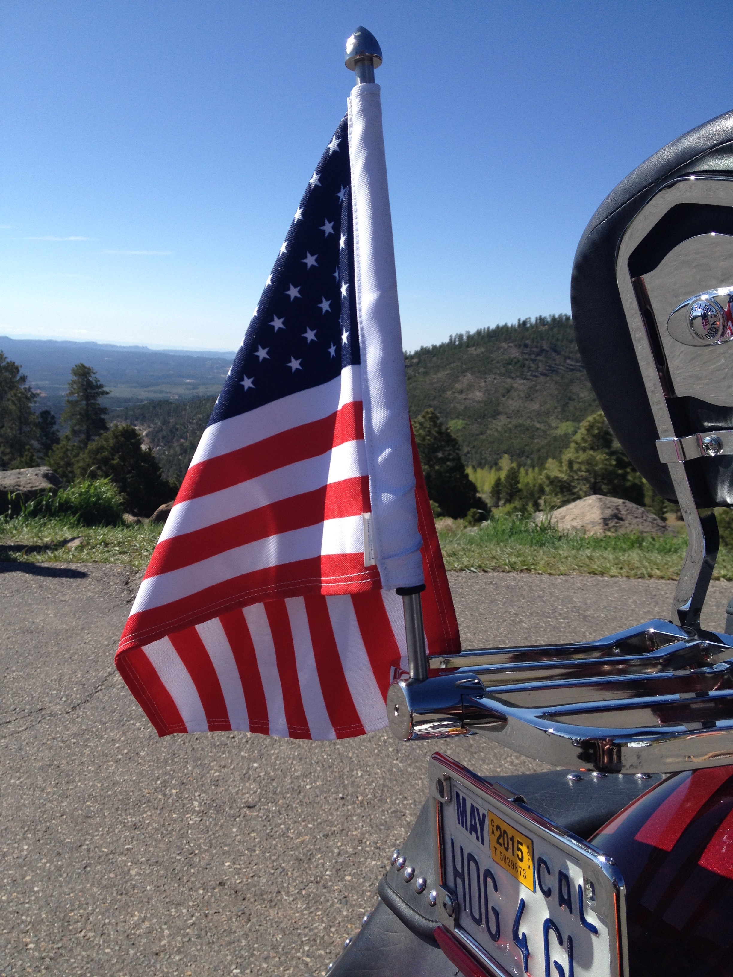
Many Americans visit cemeteries and memorials today, with volunteers placing a small flag at each grave in national cemeteries. Ray’s service was in the U.S. Air Force in the early 1950s. I, on the other hand, had a high draft lottery number (236) during the Vietnam War and as a result, didn’t wear a uniform. I will honor the sacrifice of others by flying an American flag on my Harley today.
***
We begin our ride by heading south on UT-12, reversing the route of yesterday’s ride. We’ll be on this Scenic Byway for nearly 110 miles, before turning south into Bryce Canyon National Park.
UT-12 is designated a Scenic Byway for good reason. It has rolling slickrock, variegated buttes and mesas, snaking canyons, and rock walls varnished with mineral stains.
As we leave Torrey, heading south, we see snow in the nearby mountains. It’s been cold here. Along Highway 12, depending on elevation, you can expect 10-15 inches of precipitation a year, most of it coming in the form of snow in the winter.
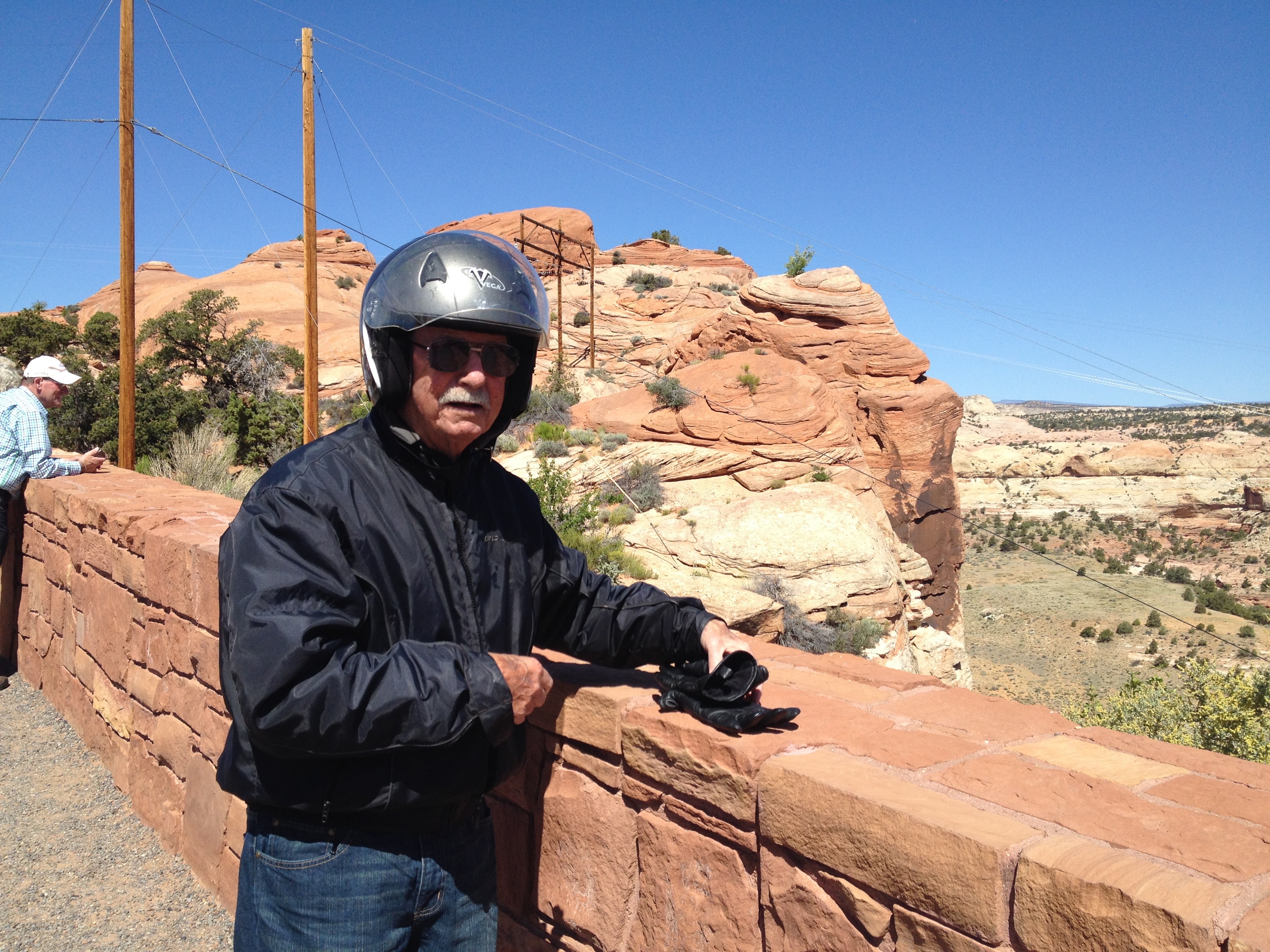
We pass by the Homestead Overlook, which has dramatic and panoramic views from a 9,400-foot high vantage point. We stop for photos and to take in the views, which include the five peaks of the Henry Mountains to the east, the magenta wedge of the Waterpocket Fold below, and the striated face of the Kaiparowits Plateau to the west.
As we ride down Boulder Mountain, we pass thick groves of quacking aspen. Eventually, we arrive in the town of Boulder, long known as the “last frontier in Utah.”

Until 1935, Boulder was so isolated that its mail was delivered by horseback rider and fresh milk was delivered to the nearby town of Escalante. Boulder is named for the volcanic boulders scattered across the slopes of nearby Boulder Mountain.
After we leave Boulder in our rear-view mirrors, we ride a famous stretch of the byway known as the “Hogback.” As the asphalt clings to this thin razorback ridge of slickrock, the terrain spills steeply off to each side, toward winding creeks and canyons below. The ride is slow, but the vistas are awesome.
Other than the spectacular displays of nature, there isn’t much along UT-12, at least not much in the way of civilization. Most of the lands surrounding the byway are owned by the public — all of us — and managed by various federal and state agencies, including the Bureau of Land Management, U.S. Forest Service, National Parks Service, and Utah State Parks.
***
One hundred ten miles from Torrey, we arrive in Bryce, exhilarated from the ride on UT-12. Bryce is the gateway to Bryce Canyon National Park.
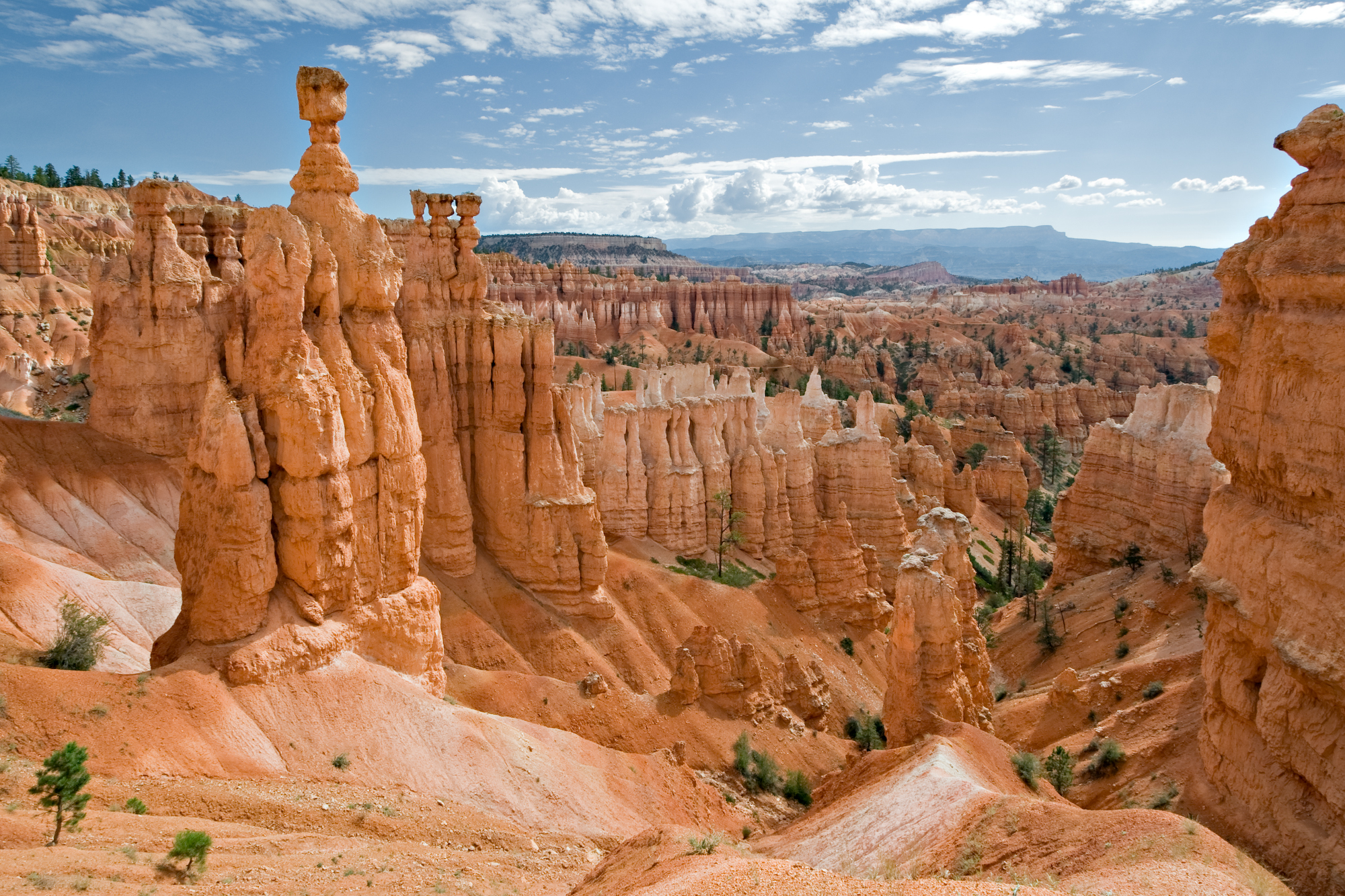
Bryce Canyon, truth be told, is really not a canyon, but a series of amphitheaters etched into the pink Claron limestone of the Paunsaugunt Plateau.
The multi-color hoodoos, pinnacles, buttresses and columns are visible throughout the park, especially along the scenic drive through the park.
Bryce is distinctive because of geological structures called hoodoos. Yes, hoodoos. They’re formed by frost weathering and stream erosion of the river and lakebed sedimentary rocks. The red, orange and white colors of the rocks make for some spectacular views. And who doesn’t like to say hoodoo?
Hoodoo is a word with many meanings. The rock singer, John Fogerty, recorded what would have been his third solo album in 1976 — titled Hoodoo. It included the song “Hoodoo Man.” The album was never released.
In his legendary song, “Born on the Bayou,” Fogerty’s lyrics include the lines: “… I can still hear my old hound dog barkin’, chasin’ down a hoodoo there.” You’ll have to ask Fogerty what he was thinking.
For a brief escape from the mountains to the bayou, click here (the hoodoo reference is at 1:46).
***
Bryce Canyon National Park is about 50 miles northeast and about 1,000 feet higher than Zion National Park, which we visited yesterday.
Once we enter the park, we ride south for 18 miles past Piracy Point, Pink Cliffs, Aqua Canyon, and Ponderosa Canyon, to Rainbow Point, which is as far as the road goes. This is the highest part of the park, at 9,105 feet. From here, you can see the Aquarius Plateau, Bryce Amphitheater, the Henry Mountains, the Vermilion Cliffs and the White Cliffs.
There are more than 50 miles of hiking trails in the park, including routes that wind around hoodoos and majestic pines. Today, Ray and I leave the hiking to others. But to show you what a full-service blog this is, I’m posting a bonus blog photo of hiking in Bryce Canyon: Sarah and me in June 2013. The wonders of scrounging through iPhoto albums on the road! See photos at bottom of blog, please 🙂
The Mormon Church sent Scottish immigrant Ebenezer Bryce and his wife Mary Ann (hooray for monogamy!) to settle land in this valley because they thought his carpentry skills would be useful. The Bryce family, with their 12 children, chose to live right below Bryce Canyon Amphitheater. You can guess how the canyon got its name.
Bryce Canyon became a National Monument in 1923, and a National Park five years later.

Click here to learn more about Bryce Canyon National Park.
***
With a 7.4 magnitude night sky, Bryce Canyon is a great place to stargaze. The skies are among the darkest in North America. The 7.4 magnitude means you can see roughly 7,500 stars with the naked eye; in many large cities, you can only see a few dozen.
The 7.4 number is on the Bortle Scale, a nine-level numeric scale measuring the night sky’s brightness in a particular location. John Bortle, an astronomer at the Brooks Observatory in Toledo, Ohio, created the scale and published it in the February 2001 edition of Sky & Telescope magazine. He wanted to help amateur astronomers evaluate the darkness of an observing site, and compare the darkness of observing sites. Sadly, my Sky & Telescope subscription lapsed years ago.
Bryce Canyon’s 7.4 magnitude night sky is Class 2 (“Typical truly dark site”), meaning: the zodiacal light is distinctly yellowish and bright enough to cast shadows at dusk and dawn, and the summer Milky Way is highly structured. At the other extreme is Class 9: Inner-city sky.

But we are in Bryce Canyon amid blazing late May sunlight and will have to just accept the 7.4 number as a good one.
So we start heading north out of the park on Johns Valley Road, which becomes UT-22. Near Otter Creek Reservoir, popular for rainbow trout fishing, we turn onto UT-62 and continue through Greenwich to UT-24. We follow UT-24 for 33 miles and arrive back in Torrey in time for an early dinner.
***
Day Five Summary: Flying the flag, hoodoos everywhere, a comeback for monogamy, testing out the Bortle Scale.
Click here to view today’s route from Torrey to Bryce Canyon National Park and back to Torrey.
What will tomorrow bring?
