
Today, we’ll have a little of everything that’s been notable about this trip. One Scenic Byway. One 10,000-foot pass. One crossing of the Continental Divide. One Colorado mountain ski town.
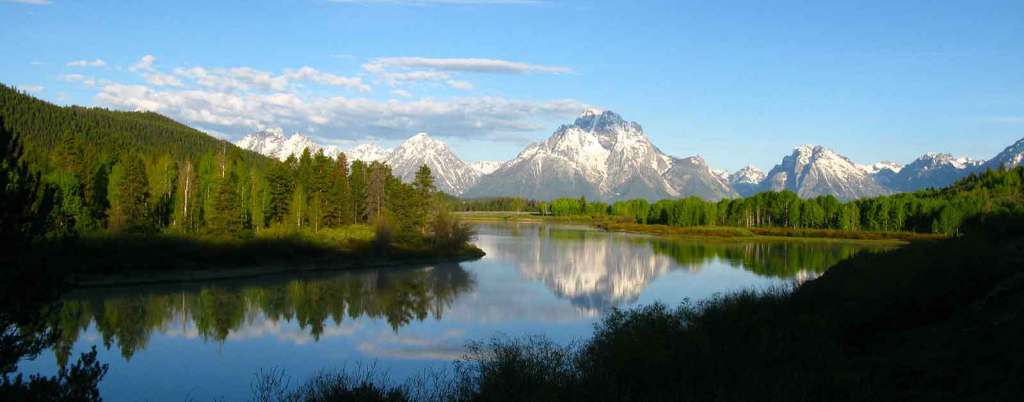
Our day begins by heading east on US Highway 34, following the Big Thompson River. The 78-mile-long river is a tributary of the South Platte River, originating in Rocky Mountain National Park. It flows into the town of Estes Park, and then through Big Thompson Canyon.

The river was named for fur trader and explorer, David Thompson, who helped forge trails for fur trading companies in the early 1800s. Some say he may have been the first white man to set foot in what is now Estes Park.
Highway 34 follows the Big Thompson River all the way to Loveland, 30 miles east of Estes Park. We don’t make it that far.

We wind our way through the spectacular canyon, with its steep walls, for about 20 miles. Seems like a nice place to fish, judging by the fishing we see along the way. The trout in the Big Thompson River are largely born in the wild, and range in size from 10 to 12 inches. The river has not been stocked since the mid-1990s. The river is home to brown trout, brook trout, rainbow trout, and cutthroat trout.
Cache la Poudre Scenic Byway
Just a few miles west of Loveland, the easternmost point on our trip, we turn north on Buckhorn Road, a twisty and fun path that takes us to Colorado Highway 14 – also known as the Cache la Poudre Scenic Byway. It’s our eighteenth scenic byway of this trip.
The byway runs along the Cache la Poudre River for 72 miles, all the way to Walden.
The Cache la Poudre River got its name from an incident in the 1820s, when French trappers had to bury some of their gunpowder during a snowstorm in the area. “Hide the powder,” is how it translates.
We’re now riding through the Cache la Poudre Wilderness and the Arapaho and Roosevelt National Forest. It’s a narrow canyon, deep and steep, carved by the river over millions of years. The water is high, and running quickly. Very popular place for kayaking. The whitewater swells to a crescendo during the spring runoff. Like many Colorado Rivers, the best waters for rafting and kayaking the Cache la Poudre are in June. Now!

On Day One of this trip, we (Sarah and I) rode along the Crystal River, as we left Carbondale and headed south. Many preservationists want the Crystal to be designated as Wild and Scenic.
There’s only one river in Colorado that has the Wild and Scenic designation: the Cache la Poudre. On October 30, 1986, President Ronald Reagan – not known for his support of the environment – signed legislation protecting stretches of the Poudre River and its South Fork upstream from the canyon mouth. (Reagan was famous for saying “Trees cause more pollution than automobiles do. If You’ve one tree, you’ve seen them all.”)
Other rivers had already received that designation as a result of the 1968 Wild and Scenic Rivers Act. The legislation says Wild and Scenic Rivers are so special, that they “shall be preserved in free-flowing condition, and that they and their immediate environments shall be protected for the benefit and enjoyment of present and future generations.”
The act has protected nearly 13,000 miles of 226 rivers in 40 states. Portions of the Cache la Poudre were named Wild and Scenic because of their outstanding recreation, scenic and hydrologic features. Thirty miles of the river are classified as Wild; 45 miles are classified as Recreational. No new dams or diversions can be built within these designated corridors. At 1,219,038 acres, the Cache la Poudre Watershed is one of the largest drainages in northern Colorado.

Cameron Pass to Walden
Our ride along the Cache la Poudre Scenic Byway continues, as we climb toward 10,276-foot Cameron Pass, the twenty-eighth 10,000-foot + pass we’ve crossed on this trip. Two more to go.
The pass was named for Robert Cameron, former Union general and founder of the Fort Collins Agricultural Colony. The pass divides the Medicine Bow Mountains to the north, and the Never Summer Range to the south.
Cameron Pass was surveyed several times for railroads, including once by the Union Pacific Railroad as a possible route through the Rockies. But no railroad was ever built over the pass.
From Cameron Pass, we begin the gradual 2,100-foot descent to Walden, 30 miles away. To our left is the Arapaho National Wildlife Refuge, a 23,464-acre site established in 1967, primarily to provide suitable nesting and rearing habitat for migratory birds. The Arapaho refuge provides a habitat for more than 200 species of waterfowl. It’s is one of more than 560 in the National Wildlife Refuge System across the US.
We’re ready for a break, and our timing is perfect. We pull into the town of Walden, population 500. There is no Walden Pond, not that we can discern anyway. We’re on the lookout for moose, as Walden is known as the Moose Viewing Capital of Colorado. More than 600 moose call this area home.

On our way into town, we passed the Moose Visitor Center, which is run by Colorado Parks and Wildlife. It’s located near the logging camp of Gould. Outside the center, there’s a seven-foot-tall sculpture of a moose, made of barbed wire.
The thought of seeing a moose along the road is intriguing. Moose are the largest members of the deer family. Colorado’s moose are the Shiras moose; mature males generally weigh from 800 to 1,200 pounds. We’ve read up on the animals, and know that they can act aggressively and charge if they sense a need to defend themselves, or their young.
We leave the Walden area, free of any moose encounters, and press on toward our next waypoint, Rabbit Ears Pass, about 35 miles from Walden.

Nearing Steamboat Springs
Rabbit Ears Pass is our ninth crossing of the Continental Divide. One more to go.
Early trappers gave the pass got its name. They were taken by its rabbit-ear-like appearance. North of the summit is Rabbit Ears Peak, which is said to be shaped like rabbit ears. Every time I’m here, I look for the ears – and don’t find them. The pass is “only” 9,426 feet.
From the pass, it’s a 21-mile descent to the valley below, where we’ll find Steamboat Springs. “The Boat,” as it’s known locally, got on the map for its winter skiing. The town of 13,000 claims to have produced more athletes for the Winter Olympic games than any other city in North America. One hundred athletes with Steamboat connections have won 19 Winter Olympic medals.
Like so many other Colorado towns, the economy of Steamboat Springs was originally based on ranching and mining – and has transitioned today to tourism. The area is home to natural hot springs, which gave the town its name. Upon first hearing a chugging sound, early trappers believed that a steamboat was coming down the Yampa River. When they saw that there was no steamboat, and that the sound was coming from a hot spring, they decided to name the spring Steamboat Spring.

In the winter, Steamboat calls itself Ski Town USA, a name they’ve trademarked. In the summer, it becomes Bike Town USA, another trademarked name, for the area’s many biking trails. Wanna trademark your business before someone else claims the name? Here’s how. I haven’t trademarked this blog. It’s yours, if you want it.
Today, our trail through town is on US Highway 40, which runs through downtown Steamboat Springs.
We leave Steamboat, and ride the remaining 125 miles home to Carbondale.

Before you know it, we roll into our driveway, and the trip is officially over.
Thirty mountain passes of 10,000 feet or more. Twenty-two Scenic Byways. Eleven Crossings of the Continental Divide. Eleven visits to national parks.
The past 18 days were memorable. And wonderful.
My summer has begun.

***
The Day in Review:
Click here to see today’s complete route from Estes Park, Colorado to Carbondale, Colorado – via the Cache la Poudre Scenic Byway.
Today’s Takeaways:
- Big Thompson Canyon, deep and steep.
- Cache la Poudre. Hide the Gunpowder
- Moose Viewing Capital, and Elk Hunting Capital.
Today’s Trivia: Wild and Scenic Rivers
Today, we followed the Cache la Poudre River for 75 miles of its Wild and Scenic ride. It’s the only river in Colorado to achieve the Wild and Scenic designation.
In all, 226 rivers across the US have been classified as Wild and Scenic.
Some of the rivers are well known, like Idaho’s Snake River, the Flathead River in Montana, and the Yellowstone River in Wyoming.
Oregon has 81 rivers – or portions of them – designated as Wild and Scenic, way more than any other state. California is next with 37. Alaska has 26.
The congressional act has protected nearly 13,000 miles of 209 rivers in 40 states, and the territory of Puerto Rico. This is less than one quarter of one percent of America’s rivers, which flow for 3.5 million miles.
More than 75,000 large dams across the country have modified at least 600,000 miles of US rivers, and made them ineligible for the Wild and Scenic designation.

The Wild and Scenic Rivers Act is administered by four federal land management agencies: the Bureau of Land Management, National Park Service, US Fish and Wildlife Service, and the US Forest Service. Each has a role in making sure the rivers they manage remain in the condition that caused them to be designated as Wild and Scenic in the first place.

When President Lyndon Johnson signed the Wild and Scenic Rivers Act into law in 1968, he noted, “An unspoiled river is a very rare thing in this nation today. Their flow and vitality have been harnessed by dams and too often they have been turned into open sewers by communities and by industries.”
Today, 55 years later, his words are just as true. There are even fewer unspoiled rivers than there were then.

And now you know.

Thanks for the ride!! Much enjoyed and more than a little jealous. Steve
LikeLike
Cure for jealousy: come along next year.
LikeLike
Epic ride again Gary! Thank you! Wishing I was with you. I know you had my room ready and I wish i was with you and Sarah for that homecoming meal that i have so enjoyed in the past. Love you both!
LikeLike
Wishing you were with me, too, Dave. Your room was ready, and the only thing missing for the homecoming dinner was you. Maybe next year? Hugs to you and Gail.
LikeLike
Your blogs are great.
Sent from my iPhone
LikeLike
Even better when you’re in them 🙂
LikeLike
Congratulations, Gary and Sarah. The blog (and pix) have been wildly entertaining and informative.
LikeLike
Thanks, Bruce. Pretty sure your (and Andrea’s) entertainment is mostly wild. See you soon (on the golf course).
LikeLike
Great trip Gary. Very sad to have had to miss it, but It looks like you guys had a fantastic time as always. One day I will check the boxes of the parks that I missed; it just may not be on the Harley. Anyway, hugs to you and Sarah and hope you guys enjoy your summer.
LikeLike