
Today’s first destination, only five miles from Moab, is Arches National Park. It’ll be our eighth national park of this trip.
Arches joins Zion, Canyonlands, Bryce Canyon and Capitol Reef, as the fifth national park in Utah we’ve visited on this trip. Utah calls them the Mighty Five. Yes, “Mighty” it’s a marketing slogan developed by the Utah Office of Tourism. But if these five parks aren’t mighty, what is?
California has nine national parks. Alaska has eight. But those states are so vast, and the parks are so spread out, it would take weeks to visit them all. Utah’s national parks are so concentrated and compressed, geographically and geologically, that we can and will visit all five of them in three days.
On this trip, we’ll visit 10 of the 63 national parks that have been created by acts of Congress, some of them multiple times (We visited the Grand Canyon South Rim and North Rim on separate days; two visits, but one park). Most of the national parks are in the western US. That’s where the bulk of this country’s natural beauty is. Ever been to Iowa?

The mission of the National Park Service is to “preserve unimpaired the natural and cultural resources and values of the National Park System for the enjoyment, education and inspiration of this and future generations.”
That means national parks should look the same 100 years from now as they do today. That’s why activities that would alter the parks in any way – mining, drilling, logging, for example – are prohibited.
Compare this to national forests, where logging is permitted, hunting is allowed, oil can be drilled, skiing is possible – because national forests are managed under a rule called “multiple use.” They’re managed for both preservation purposes, like national parks, and resource purposes.
Finally, before today’s journey begins, a few national parks fun facts. There are 20 states without any national parks – many in America’s “flyover zone,” so don’t feel alone, Kansas and Oklahoma. The largest national park is Alaska’s Wrangell St. Elias, at 13.2 million acres. The smallest is Gateway Arch in Missouri, 91 acres. The first national park, and the oldest in the world, is Yellowstone.
Every park is unique in its own way. That’s one of the defining characteristics of a national park. Arches National Park is designed to protect extraordinary examples of geologic features including arches, natural bridges, windows, spires, and balanced rocks.
Arches National Park
President Herbert Hoover created Arches National Monument in 1929, the beginning of the Great Depression. In 1971, Congress designated the area as the thirty-fifth National Park.
More than 1.8 million visitors come here each year. It’s one of the parks that’s become so popular and so crowded that a “timed entry” pass is required to manage the hordes who want to visit. That’s us.
The timed entry is designed to address roadway congestion, facility overuse, overcrowding at sites and along trails, and competition for parking. Those issues have adversely affected the quality of visitor experience, and the National Park Service decided the timed entry was the best way to manage those conflicts. As the park rangers say, the goal isn’t to reduce visitation, but to more evenly distribute it throughout the day, helping to create a higher-quality visitor experience at Arches.

So, we arrive at our designated time, and begin to explore. Our preferred method is motorcycle, with a little hiking along the way. Hiking is a very popular activity in the park. If you enjoy hiking, here are some trails at Arches you might want to try. Or if you just want to see the park on a drive-by basis, here are some good tips.

Arches has more than 2,000 sandstone arches, as well as a variety of unique geological formations. The park has the highest density of natural arches in the world. All of the park’s reddish brown or pale orange arches are Entrada Sandstone. To qualify as an arch, the opening must be at least three feet in one direction, and light must be able to pass through.
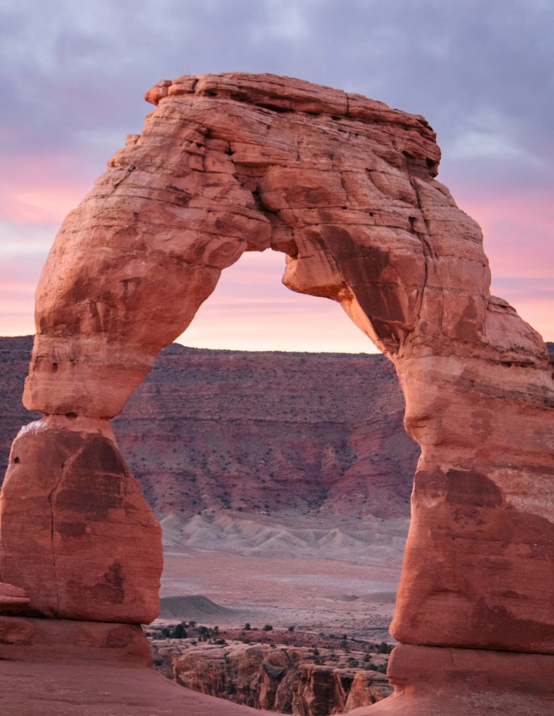
The most famous of all the arches in the park is Delicate Arch. You can find it on Utah’s license plates.
The Utah Geological Survey says arches form because the shape is nature’s most effective geometry for holding up overlying strata. The semicircular shape of an arch is actually the most effective load-bearing form in nature, because of the manner in which it distributes the compressional stresses and eliminates the extensional stresses in the surrounding rock. An arch is the shape that most effectively follows nature’s rule of getting the best natural stability with the least amount of effort.
The Natural Arch and Bridge Society defines a natural arch as “a rock exposure that has a hole completely through it formed by the natural, selective erosion of rock, leaving a relatively intact frame.” A natural arch is often defined more loosely as a rock formation composed of a curved or vaulted rock structure that supports its own weight without necessarily being a free-standing bridge.

The erosional forces that created Delicate Arch and all the others in the park, are still occurring today. That means these arches are not permanent. An example of a collapse of an arch is the fall of Wall Arch in 2008. Afterward, geologists visited Wall Arch, and noted stress fractures in the remaining formation that may cause further collapses in the future. The arch died of the same natural causes that created it in the first place: gravity and erosion. Probably, nighttime cooling-induced contraction, following a day in the hot sun, was the final straw that caused the fall. You could call it a fallen arch.
Eventually, all the arches in the park will collapse, as Wall Arch did. Just probably not in our lifetimes. By the time that happens, there should be plenty of new arches. Hard to imagine. Who will be left to blog about that?

Our park exploration ends at Sand Dune Arch, about 16 miles from the visitor center. The arch is only a few hundred yards from the main road. Getting there is like walking on a sandy beach in the middle of the desert. It’s worth the walk.

Welcome to Colorful Colorado
We leave the park, briefly return to Moab, and head south on US Highway 191.
Twenty-five miles south of Moab, at the La Sal Junction, we turn east on Utah Highway 46. We’re heading toward Colorado, where we will spend the rest of our trip.
The La Sal Mountains, Utah’s second-highest range, are to our left. La Sal means “The Salt” in Spanish. It’s believed the name comes from the salt that’s common in the soils and valleys surrounding the mountains. The La Sals have nine peaks that rise above 12,000 feet.
The highway takes us through La Sal, a town of a few hundred. There’s little to see, other than an RV park, a cemetery, a general store, and – of course, a Mormon church. Uranium mining was once a big deal here.
Soon, we enter Colorado.
I love seeing the signs that say “Welcome to Colorful Colorado.” Makes me feel like I’m home.
Turns out there are 41 of these signs on roadways, greeting visitors as they enter the state, from east and west, north and south. The signs were first erected in 1950, the year of my birth. That’s when the state’s publicity director decided it was important to warmly welcome all visitors, and the old-west style signs began popping up. The forty-second and final Welcome to Colorful Colorado sign isn’t on a road; it’s in the History Colorado Center in Denver.
Here’s a list of all the signs, and their locations.
It would be quite an adventure to ride around the state, looking for each one. Maybe that’s a future trip? Eleven of the signs are on Colorado’s eastern border with Kansas and Nebraska. That part of Colorado, the high plains 150 miles east of Denver, hardly seems like Colorado to me. It’s really more like, well, Kansas and Nebraska. It’s the antithesis of a Rocky Mountain High.

Now that we’re in Colorado, the road gets more interesting. It’s twisty, gradually climbing in elevation until we reach the Paradox Valley Viewpoint. The valley was named in 1875 by a geologist, who noted the Dolores River had a “desire to perform strange and unexpected things in the area.” The seeming paradox is that the river flows perpendicularly across the middle of the valley, instead of the normal route down its length.
About 25 miles past the Paradox Valley Viewpoint, we arrive in Naturita, a town of 500 whose name means “little nature” in Spanish. In the late 1800s, Naturita was a vibrant ranch community along the San Miguel River. The town still sits on the San Miguel River, but is less vibrant today.
In the 1930s and ‘40s, uranium mining was the main economic driver in Naturita, keeping mills busy during World War II. Eventually, market prices fell, mills closed, and people moved out of town in search of the next great thing.

Naturita is the kickoff point for the Unaweep / Tabeguache Scenic Byway. That’s where we’re headed.
Unaweep / Tabeguache Scenic Byway
The 133-mile byway offers dramatic views of the San Juan Mountains, as it follows Colorado Highway 141 through the Unaweep Canyon and the desert-like Dolores River Canyon (remember Dolores from a few days ago?). The Unaweep / Tabeguache Scenic Byway is the fourth of our trip. We’re racking ‘em up!
Unaweep and Tabeguache come from Ute languages. Unaweep means “canyon with two mouths.” Tabeguache is “where the snow melts first.”
Soon, we roll past Uravan, or at least what used to be Uravan. It’s an abandoned uranium mining town that’s now a Superfund site. Federally funded Superfund sites allow the Environmental Protection Agency to clean up the contamination. There’s plenty to clean up at a former uranium mine.
Uravan was a company town established by the Vanadium corporation in 1936 to extract the rich vanadium ore in the region. As a byproduct of vanadium extraction, small amounts of uranium were also produced, at the time mostly used as a yellow pigment for ceramics.
During World War II, Uravan provided part of the uranium needed by the Manhattan Project for the first atomic bomb. American military requirements for uranium declined in the 1960s, and in time, the domestic uranium mining industry collapsed.
The name Uravan comes from Uranium (Ura) + Vanadium (van), thus Uravan.
As we follow the Dolores River northward, the Unaweep / Tabeguache Scenic Byway gets twisty. And fun.
The Dolores River Canyon brings us to Gateway, a tiny community that may be best known, in my mind anyway, as the site of one of the best photobombs ever.


Gateway has a general store, and a very expensive resort with one of the world’s best car collections. The Gateway Canyons General Store is always a good place to fuel up and cool off. Today is no different.
For the next hour or so, we explore Unaweep Canyon. It’s the only known canyon in the world with a divide that drains water out each end. The East Creek drains east to the Gunnison River; the West Creek, which we’ve been following since Gateway, drains west to the Dolores River. The canyon cuts across the Uncompahgre Plateau.
Palisade, a Peachy Place
As the canyon ends, we turn onto US Highway 50, approaching Grand Junction. I’ve been to Grand Junction many times, often for service on my Harley. Other than the Harley store, I’m not a big fan. Today, we find a good excuse to avoid “Junction,” as the locals call it, and instead head northeast toward tonight’s destination, Palisade, about ten miles away.
Palisade, population 2,600, is named for the scenic cliffs near the town. It’s famous for its peach orchards – Palisade peaches. Every August, the town celebrates the harvest from its 500,000 peach trees with the Palisade Peach Festival, held at Riverbend Park along the Colorado River. Palisade peaches are known for being extra juicy and extra sweet, thanks to the long sunny days and cool summer nights.
Farmers in the early 1880s began to realize how rich and nutrient-filled the soil was, but there wasn’t adequate water to grow peaches and other crops. A man named John Harlow got Palisade peaches underway in 1882, when he spearheaded a canal project to divert water from the Colorado River and irrigate the region, creating a peach paradise. And the rest is sweet history.
Colorado grocery stores feature Palisade peaches in their produce section all summer. Right now.

In addition to the Peach Festival, another big event in Palisade is the annual Colorado Mountain Winefest, held every September. At the winefest, you can enjoy everything from sampling cabernet francs and chardonnays, to stomping the grapes yourself. Grapes are big in Palisade. The town of 2,600 has a thriving vineyard and winery business. You can visit more than 30 local wineries, and take a variety of wine tours.
We choose our own wine tour, which ends at the Victorian-style Wine Country Inn. It ends there because the Wine Country Inn is where we’re staying tonight. Our rooms come with complimentary afternoon wine tastings.
So, we park the bikes, and get our evening underway.

***
The Day in Review:
Click here to see today’s complete route from Moab, Utah, to Palisade, Colorado – via Capitol Reef National Park and Canyonlands National Park.
Today’s Takeaways:
- Arches National Park, a sandstone masterpiece.
- Welcome to Colorful Colorado
- Peaches and wine, a healthy combo.
Today’s Trivia: Delicate Arch – a Sandstone Icon
Of Arches National Park’s more than 2,000 natural stone arches, its most famous, and most photographed, is Delicate Arch. It’s 46 feet high and 32 feet wide, and the center of attention on Utah’s license plates. Delicate Arch is also on a postage stamp commemorating Utah’s centennial anniversary of admission to the Union in 1996.
Delicate Arch has become a widely recognized symbol of the state of Utah. It’s one of the most famous geologic features in the world.

The sandstone structure has been called quite a few names over the years, from “Cowboy’s Chaps” to “The Schoolmarm’s Bloomers” to “Salt Wash Arch.” The term “Delicate” first appeared in a January 1934 article about the Arches National Monument Scientific Expedition, which described it as “the most delicately chiseled arch in the entire area.” The name stuck. It just sounds right.
It’s almost impossible to see Delicate Arch from the main park road; you have to get out of your car to see it. Of course, the best way to see Delicate Arch is by hiking to it. Thousands do every year.

The hike is a three-mile out-and-back journey. With an elevation gain of 600 feet, much of it on slickrock, the hike should take an hour or so each way. Perhaps a bit more if you’re traveling with young children. They’ll get tired sooner than you will, and there are a few places approaching the Delicate Arch with steep drop-offs, so you’ll want to hang on to the little munchkins.

There’s little shade along the way. Bring water.
Delicate Arch is at 4,829 feet in the high desert – but it’s quite hot here in the summer. The hike is challenging, but do-able. It’s what hiking categorizers call “moderately strenuous.” Elevation gain from the trailhead at Wolfe Ranch to the arch at the end of the trail is 480 feet.

If you haven’t hiked on slickrock before, don’t be put off by the name. It’s not slick. It’s not slippery. It’s wind-polished sandstone, but the footing is very good, unless there’s snow or ice on top of the slickrock. Which there probably isn’t today.
The trail to Delicate Arch is not marked like your typical hike. Rather than having a clear path, there are piles of rocks called cairns that will guide you over the slickrock to the Delicate Arch.
Navigating is relatively straightforward, as long as you can see where you’re going. Which may be challenging if you hike to Delicate Arch at sunset, which many do. If that’s your plan, bring a headlamp for the return trek to the trailhead.

No discussion of Delicate Arch would be complete without mentioning a comical aside to its celebrated history. In the 1950s, the National Parks Service investigated the possibility of applying a clear plastic coating to the arch to protect it from further erosion and eventual destruction. The crazy idea was ultimately abandoned as impractical and contrary to what the National Parks Service stands for. Duh.

And now you know.

Another great blog Gary! Arches NP is one of my favorite memories riding with you and Randy. Beautiful! Love seeing you truly hydrating. Good job. Tell Mark, he needs to go back to photobomb school. Happy to consult. LOL! Keep riding safe!
LikeLike
Photobomb school .., I like it. You are the master!
LikeLike